Plenty of waves building through the weekend, easing early next week

Victoria Forecast by Ben Matson (issued Friday 22nd June)
Best Days: Sat/Sun: strong building groundswells, good surf west of Melbourne early mornings (though small Saturday). Wind affected and choppy east of Melbourne, though protected spots should have options Sunday. Mon/Tues/Wed: solid though easing swells with mainly light NW winds.
Recap: Light N’ly tending NW winds and small persistent swells, best suited to exposed beaches.
Today’s Forecaster Notes are brought to you by Rip Curl
This weekend (June 23 - 24)
Want to receive an email when these Forecaster Notes are updated? Then log in here and update your preferences.
Note: Today’s Forecaster Notes will be brief, as Craig is away on annual leave.
The expected new swell is still on track for the weekend.
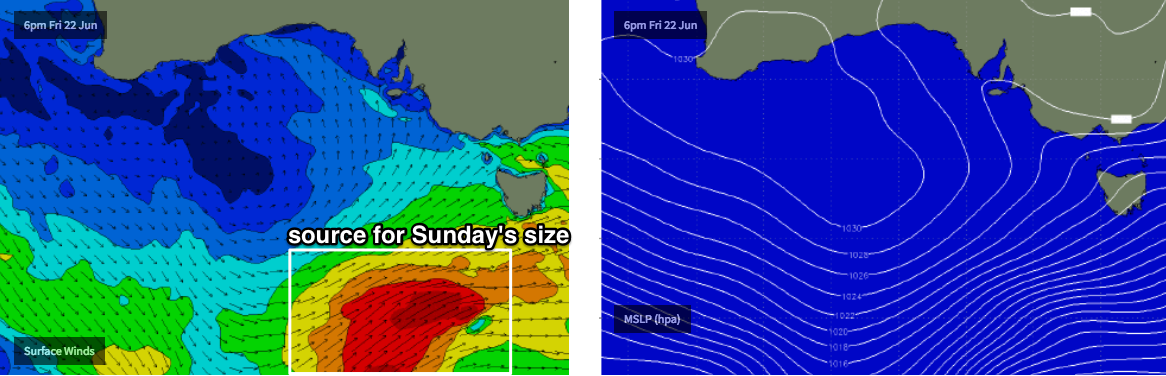
There’s a couple of components - a large long range W/SW swell reached West Oz yesterday afternoon with 10-12ft sets in Margaret River, and although that energy will decay significantly by the time it reaches us, it’ll provide some strong energy across exposed Victorian beaches over the next few days.
A secondary polar low south of the system that generated WA’s swell has kicked up some impressive long period energy too. And, the associated cold front is tracking through our swell window right now, and will kick up some mid-range energy into Sunday.
The main issue this weekend will be the winds. The aforementioned cold front is expected to cross the coast; the timing’s been moving around from model run to model run, but it’s now looking like we’ll see freshening NW tending W/NW winds across most coasts on Saturday up until late morning or perhaps even lunchtime (Cape Otway should see the wind swing first; sometime around 9-10am looks plausible right now; everywhere else will be a few hours behind).
As such there’ll be a brief window of clean conditions Saturday morning, and this will unfortunately occur when wave heights are at their smallest - we should see the new long period swell by this time but there won’t be much size to it, and definitely no consistency. Expect very infrequent 2ft+ waves on the Surf Coast for the early session, double the size east of Melbourne.
Surf size should then build slowly throughout the day, reaching 3-4ft on the Surf Coast into the afternoon (though bumpy) with much bigger surf east of Melbourne - though it may be a little undersized for protected regions like Western Port.
On Sunday, we’ll see more consistency as the mid-range energy moved through, and possibly a touch more size, generally 3-4ft but occasionally 3-5ft across the Surf Coast (also assisted buy a little more S in the swell direction). East of Melbourne it’ll be much larger and there should be good small surf throughout Western Port.
Local winds look generally SW for most regions, but the pressure gradient will relax overnight Saturday and this should allow for some local modification west of Torquay, swinging the wind around to the W/NW through the morning. It won’t be perfectly clean thanks to Saturday’s onshores but it’ll be a good improvement.
Next week (June 25 onwards)
Wave heights will slowly ease through Monday, though early morning should retain a reasonable percentage of Sunday’s size, and it’l be clean with early light NW winds tending light to moderate W’ly.
A synoptic blocking pattern upstream through our swell window over the weekend will shut down the supply of new swell for a period, so we’re looking at easing size through Tuesday and Wednesday with mainly light NW winds under a stable high pressure system.
A minor swell increase from a modest system SW of WA over the weekend (that will ultimately remain too weak to work around) however we’re looking at a significant round of solid surf from next weekend onwards as a powerful cut-off low develops int he Bight, and a series of strong secondary fronts generate an extended run of surf for the Torquay coast into the first half of the following week. More not hat in Monday’s update.
Comments
Interesting coastal obs this morning. King Island went W at 3am and SW at 4am, Portland went moderate S at 7am. South Channel Island went W at 10:30am but Cape Otway is light WNW and Aireys Inlet is still moderate NW (though expected).
Cape Otway went SW at 11am (ten minutes after the above post). Aireys Inlet went W/SW at 1pm, then SW at 1:30pm. A very slow moving trough.. always the trickiest to pin down timings.
i know its a long way out in the forecast themalben but the cutoff low in the bight you mentioned possibly forming in several days does it look like a good swell producer or better snow storms for vic alps:) at this early stage