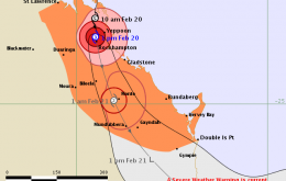
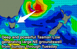
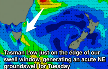
NE swell for the most part, peaking Tuesday
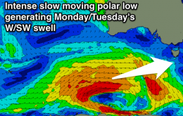
Inconsistent NE trade-swell tomorrow with a building windswell Sunday, easing Monday as a change pushes through. NE groundswell for Tuesday.
Whilst incredible to observe from a meteorological point of view (and the show ain’t over yet), these developments have certainly thrown a few curveballs our way for the surf forecast.
Easing SW swell with early N'ly winds tomorrow, tiny Sunday. Good but inconsistent W/SW swell building Monday as an onshore change moves through. Best Tuesday morning and Wednesday morning.
Easing swell with less than ideal winds Saturday. Strong increase in S/SW swell Sunday with S/SE winds and then pumping Monday with offshores and an easing S/SW swell.
It’s been a very active week of weather in the north, and some changes in the evolution of Severe Tropical Cyclone Marcia have resulted in a delay and slight downgrade in the weekend surf forecast.
Good easing swell with offshores most of tomorrow and light winds Sunday morning. Strong pulses of swell Monday afternoon and Tuesday with favourable winds for the Mid.
Easing SW swell with improving winds through tomorrow morning, favouring locations east of Melbourne. Smaller Sunday but with a straighter N'ly wind. Good groundswell pulses next week but with poor winds.
Acute and strong increase in W/NW groundswell tomorrow, secondary large NW groundswell for Friday afternoon, easing through the weekend with improving winds.
Small mix of NE swells Friday, better Saturday and larger from Sunday.
Slight lift in swell tomorrow with NE winds, better pulse Friday afternoon with onshores, easing Sunday morning with an early N'ly. Better swell building Monday, holding Tuesday.