Great Sunday, strong swell next week but with onshores

Victoria Forecast by Craig Brokensha (issued Friday 20th February)
Best Days: Saturday east of Melbourne from mid-morning, Surf Coast from late morning, Sunday, Thursday morning
Recap
Yesterday saw improving surf across both coasts as a strong new SW groundswell filled in pulsing to a good 3ft on the sets across the Surf Coast and 5ft on the Mornington Peninsula. Winds tended variable across the Surf Coast through the morning while a light NE'ly cleaned up the Mornington Peninsula through the day with glassy conditions right through until late afternoon.
Today an expected early light variable wind was unfortunately moderate from the SW across the Surf Coast with a smaller easing 2ft to occasionally 3ft of swell, while the Mornington Peninsula saw variable breezes and 4-5ft sets. A strong new SW groundswell is due into this afternoon but winds are expected to come up from the S/SE.
This weekend (Feb 21 - 22)
This evening's strong increase in SW groundswell is due to peak overnight but come tomorrow morning there should still be solid 3ft sets across the Surf Coast with 6ft waves on the Mornington Peninsula under similar winds to yesterday. An early E/NE'ly is due to swing N/NE through the mid-late morning ahead of sea breezes mid-afternoon.
The Surf Coast will be average early but an improvement should be seen on the beaches through the late morning and middle of the day.
Sunday looks great at exposed breaks with an easing 2ft+ of swell on the Surf Coast and 4-5ft waves on the Mornington Peninsula under fresh local offshore N'ly breezes. Winds are expected to persist from the N'th nearly all day creating a full day of good conditions.
Monday onwards (Mon 23 onwards)
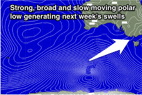
There's been no real change to the large scale developments surrounding a broad and vigorous polar low developing to the south-west of the country under the influence of a strengthening node of the Long Wave Trough.
A broad and persistent fetch of gale to severe-gale W/SW winds are already being generated in our south-western swell window with the low forecast to push slowly east while maintaining strength into tomorrow morning. This should produce an inconsistent but strong pulse of long-period SW groundswell for Monday, arriving through the day and pulsing to 3-4ft late on the Surf Coast and 6-8ft on the Mornington Peninsula.
A secondary pulse of more consistent W/SW groundswell is due into Tuesday though to a similar size, generated by a secondary front projecting up off the low through the Bight and towards us over the weekend.
This swell should peak through the day Tuesday before easing Wednesday from the 3ft and 6ft+ range respectively Wednesday morning.
Winds are still looking terrible though with an early W/NW'ly on the Surf Coast Monday morning due to give way to gusty W/SW change during the morning that will then swing SW through midday. Tuesday will then see fresh S'ly tending S/SE winds and then strengthening E/SE winds Wednesday.
Thursday should see early variable winds, but small leftover swell from 2ft on the Surf Coast mixed in with a SE windswell and then 3-4ft+ on the Mornington Peninsula.
Longer term we should see some moderate SW swell next weekend but with what looks to be onshore winds. More on this Monday. Have a great weekend!