Small average week, better swell from next week

Victoria Forecast by Craig Brokensha (issued Monday 23rd October)
Best Days: Keen surfers Surf Coast magnets tomorrow morning, possibly east of Melbourne Wednesday morning, keen surfers east of Melbourne Friday morning (only small)
Recap
Saturday's swell was a little disappointing with it coming in more windswelly rather than the stronger W/SW groundswell expected across the region, though conditions were bumpy even around Torquay with early light W/SW winds. Everywhere else was poor.
Yesterday a stronger reinforcing SW groundswell filled in, providing better 3ft waves across the Surf Coast with a morning W/NW wind, swinging onshore mid-morning.
This morning the swell was still up around 2-3ft on the Surf Coast and 4-5ft on the Mornington Peninsula with a reinforcing mid-period swell but this will ease through the day as this morning's W/NW winds around Torquay give into afternoon sea breezes.
This week and weekend (Oct 24 - 29)
Smaller waves are due into tomorrow as the activity from the weekend continues to subside, leaving small fading 2ft sets at magnets on the Surf Coast and 3ft+ waves on the Mornington Peninsula. Winds still look a bit average for locations east of Melbourne with a variable breeze from the west likely to leave conditions a little lumpy/wobbly. The Surf Coast should be clean, but again only small.
Our small increase in inconsistent SW groundswell for Wednesday is still on track, but it looks like it'll be a touch smaller than expected on Friday.
This swell was generated late week and over the weekend by a slow moving polar low south-west of WA.
 An inconsistent 2ft+ wave is due on the Surf Coast through the morning, easing back later in the day with 3-4ft waves on the Mornington Peninsula.
Winds are looking suss with a a deepening trough over South Australia results in freshening E/SE tending SE winds, possibly lighter out of the E early, favouring the Mornington Peninsula.
The trough will then move across us overnight, bringing onshore S/SW winds to all locations Thursday as the swell eases from a small 1-2ft on the Surf Coast and 3ft to the east.
 There's no new swell due into the end of the week, with tiny fading surf expected on Friday as winds swing back around to the N/NE. The Mornington Peninsula might offer 2ft sets early, fading through the day with no surfable waves Saturday under W'ly winds.
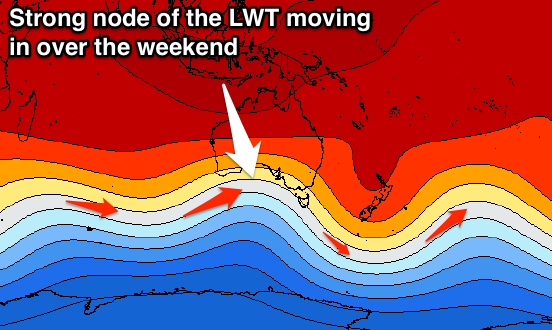
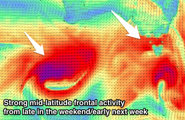
Longer term the outlook is better with a vigorous mid-latitude frontal progression due to fire up across WA later this week, moving east and over towards us during the weekend and early next week while strengthening.
This will be linked to a strengthening node of the Long Wave Trough moving in slowly from the west over the weekend, with moderate to large windy surf out of the W/SW expected from Monday, but more on this Wednesday.