Good Surf Coast tomorrow, beaches Sunday

Victoria Forecast by Craig Brokensha (issued Friday 11th August)
Best Days: Surf Coast Saturday, exposed beaches Sunday, keen surfers Surf Coast Tuesday afternoon and Wednesday morning
Recap
Tiny to flat conditions across the Surf Coast yesterday with inconsistent 1-2ft waves on the Mornington Peninsula, but a strong N'ly wind made it very tricky to surf.
Today has started as expected with tiny waves on the Surf Coast under a W/NW breeze, with poor onshore waves to the east.
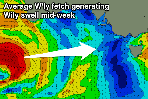
A good new W/SW swell is starting to show on the coast, generated by a broad and vigorous mid-latitude front pushing towards us yesterday and this morning. We'll see sets reaching 3ft across the Surf Coast into the afternoon with 6ft waves on the Mornington Peninsula as winds persist from the W/NW. Keep an eye on the surfcams for indications of this new swell.
This weekend and next week (Aug 12 - 18)
This afternoon's increase in W/SW swell is expected to peak overnight/early tomorrow morning, and if it weren't under dark we'd see 3-4ft waves on the Surf Coast and 6ft+ waves to the east.
The secondary intense front pushing in over the active sea state this afternoon and evening has been downgraded a little, with just a quick burst of gale to severe-gale W'ly winds due to be projected through our western swell window.
With this the size of tomorrow morning's pulse has been downgraded a touch.
We're now looking at good fun 4ft sets across exposed breaks on the Surf Coast through the morning, easing into the afternoon and further from 2-3ft Sunday.
The Mornington Peninsula should see 6ft to occasionally 8ft sets in the morning, easing through the day and further from 4-5ft Sunday.
Conditions will be great on the Surf Coast tomorrow with a W/NW offshore persisting all day, while Sunday looks fun on the beaches with N'ly offshore winds and easing surf.
 Come Monday the surf will become tiny on the Surf Coast, while the Mornington Peninsula will be average with small to tiny waves and a N/NW breeze.
Next week's tricky outlook is still that, with a broad low stalling south-west of WA generating multiple fetches of gale to severe-gale W'ly winds unfavourably through our western swell window.
This won't be favourable at all for the Surf Coast, while winds from the NW-W/NW won't favour the Mornington Peninsula which will pick up some fun sized surf.
At this stage the best pulse of W'ly swell is due to fill in Tuesday, building to 2ft to possibly 3ft into the afternoon at magnets on the Surf Coast, easing from a similar size Wednesday morning. The Mornington Peninsula should see larger 4-6ft sets, but a fresh N/NW tending NW breeze Tuesday and W/NW winds Wednesday will only favour the Surf Coast.
We'll see the mid-latitude system moving east and across us Wednesday next week, producing a moderate sized W/SW swell through the end of the week with strong W/NW winds. Beyond this there's nothing too significant on the cards, but more on this Monday. Have a great weekend!
Comments
New swell, pity about the high tide..
Torquay looking the goods this morning!
Crikey.. how's Cape Sorell?
Hey, Vic Local!
On Thursday you wrote (in the comments on Wednesday's Forecaster Notes):
"4-5ft+ from a 253 degree swell delivered from 973hp low? Yeah right. Craig. Buy yourself a compass and a victorian map. Take a 253 degree bearing from Bells and have a look how much ocean there is on those coordinates."
Would love to hear your thoughts on today's surf.
Happy to admit I got it wrong. There's more south in the swell than expected. Forecasting is of course inexact.
My big beef with you guys is you constantly get it wrong in the same direction. e.g. over calls. This of course brings crowds and aggression. You can't be perfect, but if you're regularly wrong in a predictable pattern, it's time to re-evaluate your methods.
But hey, well done today Craig and remember a broken clock tells the right time twice a day.
All good VL, we're always happy to admit when we get it wrong - and these Forecaster Notes are a great way to continue the discussion. I learn something new every day (as does Craig), and I hope our readers do too.
The most important thing is to voice your thoughts in advance, so we can then debate the merits of the forecast on a level playing field.
It's kinda self defeating to pipe up after the fact and announce "I always knew it was going to be bigger/smaller/earlier/later than forecast" - because in my experience, if left to recollection, people tend to only remember the things they get right. Everyone's got an opinion at the pub, but once it's uploaded for public scrutiny (as we have done every day for fiffteen years), its much easier to see whether you were actually right or wrong. So, kudos for commenting in advance.
Back to the state of play - and Pt Nepean recorded some impressive figures in the early hours of the morning, around 4m Hsig and up to 7.3m Hmax. The narrow range in period data (between Tp and Tsig) also show that it's a very strong, defined swell event from a single source.
Hey Ben, wave weren't anything to get excited about today , junky swell and shifting westerly winds.
Got time to answer the question I asked in the last forecast thread about s/e swells in Vicco?
Sorry mate, I missed that Q.. can you please ask it again?
Proper s/e groundswells are becoming more common in Vic.
SE groundswells - you mean short range events through Bass Strait? Or long range SE groundswells affecting the Gippsland, and then Western Vic (west of Cape Otway)?
The short ones, could you delete the last half of the second line please ;)
Had a few over the last few years from lows on the N/E tip of tassie.
They've gotten into all of the west coast, including the surfcoast.
Are they becoming more common? I am not really sure. The weather patterns responsible for these kinds of swells are more frequent in summer (generally high pressure ridges over Tasmania, and an inland trough of low pressure over Vic/NSW) so if anything, perhaps broadscale changes are altering the time of the year when they are occurring - but I don't have any conclusive data to suggest either way.
It's also worth keeping in mind that perhaps we're just more aware of them now, as the associated kinds of synoptic patterns are such that you'd ordinarily write off the Surf Coast for waves. It's only now that we're able to observe, record and discuss these patterns (including their origins) that it looks like the frequency has increased.
It's akin to the supposed increase in tornadoe events across inland regions - they have always happened, it's just that everyone now has a 5 megapixel camera in their pocket, and a wealth of global distribution platforms (like Facebook) so that we're "seeing" more and more of these events - which leads some people to the conclusion that they're happening more. They're not.. it's just that we have access to exponentially more information than we used to.
Looking very tidy across the Bellarine Peninsula this morning - here's one wave (in two frames) from 13th Beach:
Some nice bowls down the beach too.
13th Beach looking fun and clean this afternoon.
Thanks ben some good comments there mate .
My question got missed twice btw , its normal
What were those questions sorry Clam?