Tiny ahead of strong westerly pulses

Victoria Forecast by Craig Brokensha (issued Wednesday 9th August)
Best Days: Surf Coast Friday afternoon onwards
Recap
Good fun waves across the Surf Coast yesterday with a mix of easing W/SW groundswell and S/SW windswell from the 3ft range with all day offshores.
Today the swell has backed off further with 1-2ft leftovers on the Surf Coast, while the Mornington Peninsula was around 3ft and lumpy and bumpy early. We should see the beaches to the east clean right up during the day as winds remain light from the N'th into the afternoon.
This week and weekend (Aug 10 - 13)
Overnight we'll continue to see the surf dropping, and a strong N/NE tending N/NW wind will blow away what ever little swell is left tomorrow. There'll be nowhere to recommend for a surf.
We've had a slight upgrade in both Friday and Saturday's swell with a mid-latitude front pushing in under the Bight tomorrow expected to now project a great fetch of severe-gale W/SW winds through our western swell window.
This will generate a moderate sized W/SW groundswell for Friday, tiny most of the morning building to a good 3ft on the sets across the Surf Coast into the afternoon, with 6ft waves on the Mornington Peninsula.
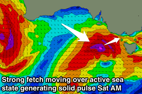 A secondary tight and intense low will then race in on the back of the active sea state and generate an additional fetch of severe-gale to storm-force W/SW winds, right on our door step Friday afternoon and evening.
This should produce a larger W/SW groundswell pulse for Saturday, which at this stage looks to be in the 4-5ft+ range at swell magnets on the Surf Coast and 8ft on the Mornington Peninsula.
With the close proximity of the low and dynamic structure, we'll take one last look at this swell on Friday with a lot more confidence.
The swell will pulse and ease quickly into the afternoon, with Sunday revealing half the size and easing sets from the 3ft range on the Surf Coast and 4-6ft on the Mornington Peninsula.
Winds through this event look great for the Surf Coast with fresh W/NW breezes Friday and Saturday, NW tending N/NW Sunday.
Next week onwards (Aug 14 onwards)
Next week is looking super tricky, but in summary, we'll be looking at small west swells with north-west winds.
A broad and multi-centred low is forecast to develop south-west of WA, with various fetches of severe-gale winds either being too north of our swell window, or angled more towards Indonesia.
With this we're not due to see hardly any size out of the west, well not enough for the Surf Coast which will be clean.
We may see some swell as the low moves east across us mid-late next week, but more on this Friday.
Comments
going to put it out there, saturday will be junky.
I'd saw more raw, with a wide mix of different swells of different sizes and periods. Close-spaced double-ups etc.
Junky for me is when the wind is more onshore.
It was 1ft tonight , max .
4-5ft+ from a 253 degree swell delivered from 973hp low? Yeah right. Craig. Buy yourself a compass and a victorian map. Take a 253 degree bearing from Bells and have a look how much ocean there is on those coordinates.
Hey Vic Local. You'd be surprised how much swell is generated out of Loutit Bay. Gotta be a fetch of at least 5km in that body of water.
Proper s/e groundswells are becoming more common in Vic, why's that Craig or Ben?
Slight change in the position and strength of the secondary low.
Hence the wording "With the close proximity of the low and dynamic structure, we'll take one last look at this swell on Friday."
I'd be thinking more the 4ft range on the sets now (5ft not out of the question), but I'll check again tomorrow.
I might add, the first initial front is looking great, with the swell peaking overnight/early Saturday but the second system will be moving in over an active sea state = larger than normal surf size, even taking in the west swell direction.