Small westerly swells ahead of a strong increase Friday afternoon

Victoria Forecast by Craig Brokensha (issued Monday 22nd May)
Best Days: East of Melbourne tomorrow, both coasts Thursday, both coasts later Friday and Saturday
Recap
Fun clean waves on both coasts Saturday morning, easing from a small peaky 2ft on the Surf Coast with fun but inconsistent sets on the Mornington Peninsula. Sunday was small to tiny and best around the low tide east of Melbourne.
Today the surf has remained small to tiny with only a slight increase in W'ly groundswell due later today on the Mornington Peninsula to 3-4ft.
This swell has hit the Cape du Couedic wave buoy in South Australia, so will hopefully kick this afternoon as winds remain offshore.
This week and weekend (May 23 – 28)
Early-mid this week is looking a little hit and miss.
This afternoon's acute W/SW groundswell should provide fun sets on the Mornington Peninsula and maybe 1-2ft waves on the Surf Coast, fading back into tomorrow leaving smaller weaker waves on both coasts.
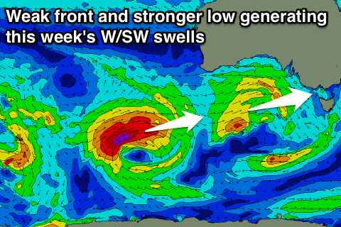
Currently the mid-latitude low is aiming a weak fetch of strong W/SW winds just within our swell window in the Bight. This fetch will slowly move east closer towards us and more into the Surf Coast's swell window tomorrow, with the best fetch projected towards us tomorrow afternoon and Wednesday.
 With the lack of strength in the fetch and initial position to the north today the Surf Coast isn't due to see any size tomorrow, with 1-1.5ft sets possible at swell magnets. The Mornington Peninsula should be around 3ft with the odd 4ft set possible.
Conditions will be good for the Mornington Peninsula through the morning with a moderate to fresh N'ly, tending NW through the afternoon.
Wednesday morning will remain small to tiny through the morning, with a slight increase in size through the afternoon to 2ft on the Surf Coast and 4-5ft on the Mornington Peninsula. A morning W/NW wind will favour the Surf Coast, but with tiny waves, swinging W/SW into the afternoon as the swell builds.
Thursday morning looks like the best time to get out on the Surf Coast with early 2ft to occasionally 3ft sets at magnets (easing through the day) with NW-N/NW winds. This will also create workable waves on the Mornington Peninsula with 4-5ft+ surf.
A low point in swell is due Friday morning with small 2ft sets on the Surf Coast and 4ft waves on the Mornington Peninsula with a NW tending lighter N'ly breeze.
Into the late afternoon a strong new long-period W/SW groundswell is due, produced by an intense low that's currently north-east of Heard Island.
This low is generating a tight fetch of storm-force W/SW winds and will slowly weaken while pushing gradually east closer towards us over the coming couple of days, finally passing south-west of us Thursday evening while in a much weaker state.
A good long-period W/SW groundswell will be generated, arriving through the day Friday and kicking strongly later in the day. The Surf Coast should build to 3-5ft by dark, peaking overnight and easing from the 4ft range Saturday. The Mornington Peninsula should see 6-8ft sets on dark, and easing 6ft+ waves Saturday.
As talked about above, winds will be favourable late Friday, while Saturday should see N'ly offshores persisting all day, NW into Sunday.
Another similar long-period W/SW groundswell is due later Sunday/Monday, but with a little less size and winds from the north-west, but more on this Wednesday.
Comments
Craig what will the winds be like at Winki around 4.10pm Thursday. Will it be worth leaving work early for and using half a tank of fuel?