Good clean waves to end the week

Victoria Forecast by Craig Brokensha (issued Wednesday 3rd May)
Best Days: Both coasts Thursday and Friday, possibly Surf Coast early Sunday
Recap
Great waves on the Surf Coast yesterday morning with clean 3-4ft reef waves, building further into the afternoon but with a fresh onshore change.
This morning we've seen the swell hang in at a good 3-5ft on the Surf Coast with morning offshores, while everywhere else was larger and messier.
We'll see winds tend onshore through the middle of the day again on the Surf Coast but without too much strength keeping fun waves hitting the reefs most of the day as the swell slowly eases.
This week and weekend (May 4 - 7)
Our current SW swell will continue to ease over the coming days, mixed in with some new S/SW swell generated by a polar front yesterday.
We're looking at a bit more size with easing 3ft sets due on the Surf Coast and 4-5ft+ waves on the Mornington Peninsula.
Conditions are looking excellent for both coasts with light local offshore winds, tending variable into the afternoon.
Friday looks smaller with fading 2ft waves on the Surf Coast and 3ft to occasionally 4ft sets early on the Mornington Peninsula with a straight N/NE offshore (N/NW on the Surf Coast).
 The weekend is still looking quite dynamic with a vigorous mid-latitude low approaching from the west due to bring a strong onshore change through the afternoon.
This system isn't expected to develop into a low until east of us and off the Tasmanian Coast.
With this we may see a period of W/NW winds on the Surf Coast through Sunday morning along with a solid mix of new swells.
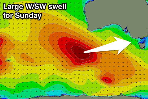
The most significant swell will be a moderate to large W/SW groundswell which has already started to be generated by a vigorous polar frontal progression firing up west-southwest of WA.
A fetch of gale to severe-gale W/SW winds are being aimed through our western swell window and we'll see this system continuing to roll on towards us over the coming days, producing persistent gale to severe-gale W/SW winds.
This will generate a strong long-period W/SW groundswell for Sunday, peaking through the middle of the day to 4-6ft on the Surf Coast and the 8ft range on the Mornington Peninsula. Also in the mix will be moderate amounts of mid-period and SW windswell from the frontal system proper.
 Saturday morning will be small and to 2ft on the Surf Coast and 3-4ft on the Mornington Peninsula with a fresh NW offshore ahead of the mid-late afternoon W/SW change.
Sunday should see an early W/NW breeze around Torquay with gusty SW winds everywhere else. (We'll confirm this Friday).
Into early next week the W/SW and SW swells will ease but the low stalling off the Tassie East Coast will continue to create average S'ly winds, more variable Tuesday.
Longer term another very strong polar frontal progression firing up in the Indian Ocean should generate a moderate sized W/SW groundswell for later next week with favourable winds, but more on this Friday.