Extended period of very large waves throughout Victoria

Victoria Forecast by Ben Matson (issued Wednesday 29th March)
Best Days: Thurs: very large swell with a brief window of OK winds in Torquay. Best suited to protected locations. Fri: better winds and solid, easing swells. Sat/Sun: very large swell with tricky winds, but windows of opportunity. Late Sat looks to have the most size but Sun AM should see the best combo of size and conditions.
Recap: Although the Cape Sorell buoy recorded a significant increase in size on Tuesday, much of this regional swell was W/NW and thus didn’t provide a major increase in size across the Victorian coast. However, a larger swell with more W/SW in its direction filled into the region overnight and is now boosting surf size across the coast, and will continue to increase throughout the day ahead of a peak on Thursday. The Surf Coast reefs are now 4-5ft, whilst the East Coast is pushing 8ft+. Winds are light to moderate NW so conditions are generally very clean.
This week (Mar 28 - 31)
Note: Forecaster Notes will be brief this week as Craig’s on leave.
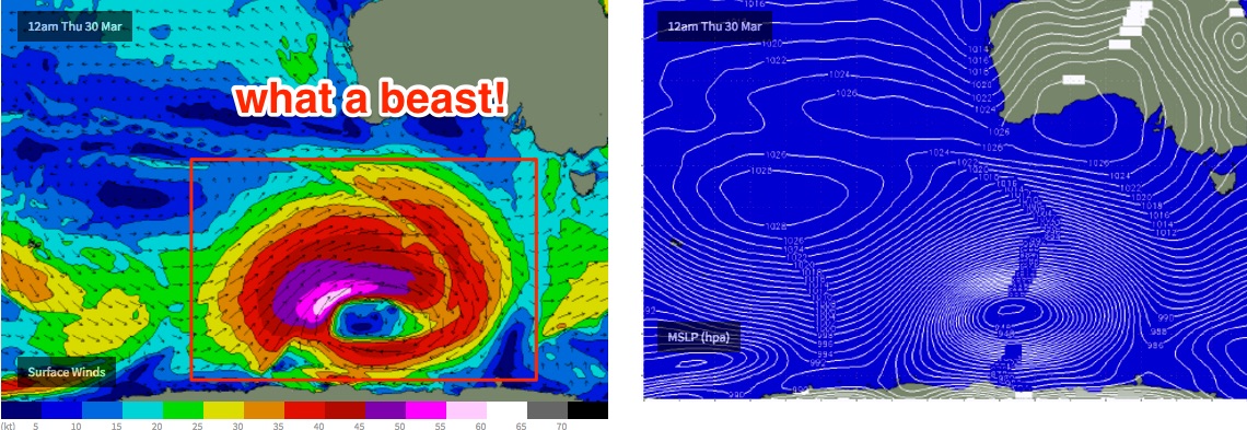
So, here comes the expected large swell for Thursday.
There’s nothing in the datasets that suggests Monday’s estimates should be revised; that is we’re looking at a peak across the Surf Coast around 6-8ft with much larger surf east of Melbourne around 10-12ft. Western Port will obviously be the best choice here on Thursday.
Winds do look tricky with a broad SW flow expected throughout the day. However the Surf Coast is likely to experience a localised offshore wind for a few hours around dawn which should maintain reasonably clean conditions. It won’t last long though.
Size will ease rapidly into Friday and winds should become lighter W’ly as the front clears to the east. West of Melbourne should see a W/NW wind trend during the day, and there’ll be plenty of solid waves early (4-6ft) down to 3-4ft by the afternoon. Western Port should also be a good choice east of Melbourne.
This weekend (Apr 1 - 2)
As alluded to in Monday’s notes, we have another large swell expected this weekend.
The models have slightly broadened and stalled the low in its eastward track, which has increased the size potential a little though pulled the swell direction back to the SW. However it also means that the associated front will clip the coast, bringing a SW change throughout the day.
This swell is expected to arrive throughout Saturday, starting off a little smaller than late Friday but rapidly increasing through the afternoon. It’s an excellent direction and alignment for the Surf Coast where we should see solid 8ft+ sets by late in the day, in fact I wouldn’t be surprised if it became even bigger right on dark at the region's reliable swell magnets surrounding Bells Beach (rogue 10ft+ wash-throughs). The reason for this is that core surface winds around the low are expected to reach 50-60kts+, with a broad region of 40-50kts, which means peak swell energy will be up in the 18 second range (leading edge periods could be higher; though the fetch's proximity to the mainland may slightly reduce this number though).
The early smaller session on Saturday should see a decent period of NW winds through the morning but W/SW tending SW winds are expected late morning through lunchtime and will probably occupy the afternoon. At this stage I’m expecting it to be around 15-18kts so this should provide some workable options if you’re prepared to put up with some surface bumps.
Saturday’s late large increase will ease steadily from Sunday morning onwards. Early morning should still see occasional 6-8ft+ bombs across the Surf Coast reefs, but it’ll drop to 4-6ft by the early afternoon, possibly a shade smaller late in the day. Model guidance suggests a light to moderate S’ly flow on Sunday but the Surf Coast should see topographical influences creating a light W/NW. However there may be some leftover wobble on top.
East of Melbourne - well, it goes without saying that this is a weekend only suitable for Western Port, which should be fantastic through Saturday afternoon and Sunday. Wave heights at exposed beaches should reach 12ft+ at at the height of the swell.
Next week (Apr 3 onwards)
There are bunch of moderate fronts expected to push through our far swell window over the weekend, setting up fun small to medium sized swell around Wednesday of next week (occ 2-3ft+ waves in Torquay). Otherwise, there are no major swells on the long term charts.
Comments
Ain't small this AM.
There are long lines of closeouts well offshore from 13th Beach (inline with the bombies, though breaking in places I haven't seen break before).
Huge bombies breaking out behind cheviot beach in Portsea today
Hard to tell how big