Small swells, cleanest as they ease

Victoria Forecast by Craig Brokensha (issued Monday 16th January)
Sign up to Swellnet’s newsletter and receive the Victorian Forecaster Notes and latest news sent directly to your inbox. Upon signup you'll also enter the draw to win a surf trip to P-Pass for you and a mate (there's only 2 weeks left to go). It doesn’t get much easier so click HERE to sign up now.
Best Days: East of Melbourne tomorrow morning, Friday morning east of Melbourne, Sunday morning east of Melbourne
Recap
A bit of a disappointing weekend swell wise. Even with the westerly bias, the track, strength and Cape Sorell readings were good, but even the Mornington Peninsula failed to see any major increase in size.
Protected spots on the Surf Coast were clean most of the day as the swell built, while Sunday saw an early W'ly and workable conditions around Torquay.
A reinforcing S/SW groundswell due through the day yesterday has kept some decent size hitting both coasts into this morning with clean 3-4ft sets across magnets on the Surf Coast and 4-6ft waves on the Mornington Peninsula. A steady easing trend is occurring through the day and afternoon sea breezes will kick in.
This week (Jan 17 - 20)
The weekend's swell will continue to ease through tomorrow and both coasts should be clean early with an early N'ly east of Melbourne and N/NW breeze on the Surf Coast.
Size wise there won't be much left on the Surf Coast with 1-2ft sets at magnets, while the Mornington Peninsula will be best with easing 3ft+ sets.
A low point is due early Wednesday morning, but a mix of long-range and very inconsistent W'ly swell along with a short-range W/SW swell are due to build into the afternoon.
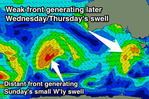 The long-range energy was generated late last week and into Saturday by a distant low in the southern Indian Ocean, while the remnants of this low are moving towards us under the country, generating a persistent fetch of strong W/SW winds before crossing Tasmania early Wednesday.
We should see the long-range energy arriving before the short-range swell, but only an inconsistent 1-2ft wave is due on the Surf Coast Wednesday morning, and 3ft+ on the Mornington Peninsula. Into the afternoon the short-range energy should see better 2ft+ sets on the Surf Coast and 4ft+ waves on the Mornington Peninsula head of a peak early Thursday around 2-3ft and 4-5ft+ respectively.
The swell will ease off through Thursday, smaller Friday.
Winds on Wednesday will be poor with a fresh SW'ly, associated with the front pushing through, while S/SE winds will continue to create average conditions Thursday as a ridge of high pressure slowly moves in.
Friday looks clean with a NE tending NW breeze ahead of an afternoon change, but the beaches east of Melbourne will be the pick with the most size.
This weekend onwards (Jan 21 onwards)
Saturday isn't looking too flash with small to tiny amounts of swell and a S/SW onshore in the wake of Friday afternoon's change.
Sunday should see a new small mix of inconsistent W/SW groundswells, again long-range energy mixed with short-range swell. Size wise these swells look smaller than Thursday's with 1ft to maybe 2ft sets on the Surf Coast a and better 3ft sets east of Melbourne. Winds will be best for the Mornington Peninsula, but we'll review this Wednesday.
Comments
Yep, Saturday sure was disappointing size and strength wise.
Winds as expected.