Slow increase in size all week, large powerful swell for the weekend

Victoria Forecast by Craig Brokensha (issued Monday 9th January)
Sign up to Swellnet’s newsletter and receive the Victorian Forecaster Notes and latest news sent directly to your inbox. Upon signup you'll also enter the draw to win a surf trip to P-Pass for you and a mate. It doesn’t get much easier so click HERE to sign up now.
Best Days: East of Melbourne Tuesday morning, Surf Coast Wednesday morning and early Thursday, both coasts Friday morning, large swell but limited options on the weekend
Recap
Small clean waves Saturday morning with a kick in new SW groundswell to 2ft max on the sets on the Surf Coast and 3ft or so on the Mornington Peninsula.
Sunday was then tiny on the Surf Coast, while the Mornington Peninsula was small and bumpy.
Today a small W/SW swell has come in at 1-1.5ft on the Surf Coast but the westerly swell direction has favoured the Mornington Peninsula with bigger 3ft to occasionally 4ft waves and workable conditions.
This week (Jan 10 - 13)
Similar levels of W/SW swell are due to persist through tomorrow with tiny waves continuing on the Surf Coast to 1-1.5ft and sets around 3ft to occasionally 4ft on the Mornington Peninsula.
A variable wind should create OK conditions on the Mornington Peninsula through the morning before sea breezes kick in.
Later in the day and more so Wednesday some slightly better W/SW groundswell is due to fill in
This swell, generated over the weekend and into early this morning is being generated by a persistent fetch of weak W'ly winds through our western swell window.
The Surf Coast should see 2ft+ waves at magnets, with 4-5ft waves on the Mornington Peninsula during the morning.
The stronger pulse of groundswell due later in the day and Thursday morning is still on track, but again it's been downgraded slightly, with a very intense but tiny mid-latitude low due to fire up south-west of us Tuesday evening.
A late kick to 3ft should be seen on the Surf Coast Wednesday but with onshore SW winds (W/NW through the morning).
The swell should ease back from a similar size Thursday morning (5-6ft Mornington Peninsula) but a trailing fetch of strong W/SW winds should produce a reinforcing mid-period SW swell for the afternoon, keeping similar surf hitting both coasts.
We should then start to see the swell easing Friday from 2-3ft on the Surf Coast and 4-5ft+ on the Mornington Peninsula.
Winds on Thursday aren't ideal but we should see an early W/NW'ly on the Surf Coast before S/SE breezes kick in, while Friday looks great with a N/NE offshore, possibly tending W'ly into the afternoon.
This weekend onwards (Jan 14 onwards)
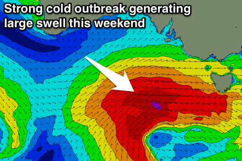 We've got a strong cold outbreak on the cards for this weekend, and luckily, this system isn't set to change much at all.
An intense mid-latitude low drifting in from the Indian Ocean and under the country later this week, is expected to strengthen significantly under the Bight, aiming a slow moving fetch of gale to severe-gale W/SW winds through our swell window.
A large, powerful long-period and consistent W/SW groundswell will be generated, building Saturday and peaking Sunday morning.
We're looking at 6ft+ surf on the Surf Coast and 10ft waves on the Mornington Peninsula at this stage with SW tending S/SE winds. This is a real shame, and we'll review this likely hood of an early W/NW'ly around Torquay on Wednesday.
A NE breeze is expected to kick in again Monday with moderate to large levels of easing swell. More on this Wednesday.