Poor Tuesday, good Wednesday and Friday, decent weekend

Victoria Forecast by Craig Brokensha (issued Monday 12th September)
Best Days: Wednesday Surf Coast, Friday Surf Coast, Saturday both coasts, Sunday Surf Coast
Recap
Poor start to the weekend with a new swell spoilt by onshore W/SW winds. The surfed kicked stronger into the afternoon, but Sunday was the day with a mix of strong W/SW groundswells filling in.
The Surf Coast was a good clean 3ft+ through the morning, kicking to a larger pumping 5ft+ or so into the afternoon along with all day NW winds. The Mornington Peninsula was larger but bumpy, best in Western Port.

Photo by Judy Scanlon, click through for a gallery from the weekend.
This morning the swell was down a touch and winds less than ideal but workable for keen surfers on the Surf Coast. A variable breeze has persisted into the middle of the day keeping conditions relatively clean.
This week (Sep 13 - 16)
Tomorrow is still looking poor unfortunately as a deepening inland surface trough directs a fresh E/SE'ly into the coast.
This will spoil a good pulse of new SW groundswell, generated by a strong polar front over the weekend and should keep the Surf Coast up around 3-4ft+ with 6ft+ sets on the Mornington Peninsula, easing into the afternoon and further Wednesday.
 Conditions should improve Wednesday as the low/trough sits to our west, directing W/NW winds across the coast. Easing 3ft waves are due on the Surf Coast ahead of a possible late kick in new inconsistent SW groundswell that's due Thursday.
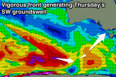
This swell has been and is still being generated by another vigorous polar storm, with a severe-gale fetch of W/NW gales generated in our south-western and southern swell windows.
Strong 3-4ft+ sets are due on the Surf Coast again with 6ft sets on the Mornington Peninsula but the low will move east bringing strong onshore SW winds.
Once the low continues east winds should tend back to the NW Friday cleaning up the easing swell from 3ft on the Surf Coast and 5-6ft on the Mornington Peninsula.
This weekend onwards (Sep 17 onwards)
Into the weekend we're expected to see a few more pulses of S/SW and SW groundswell from continued polar frontal activity to the south-west and south of WA.
The best pulse is currently due Sunday (3-4ft Surf Coast) and winds are great Saturday from the N'th, more W'ly into Sunday, but we'll review this again Wednesday.