Fun pulses of W/SW groundswell generally clean each morning

Victoria Forecast by Craig Brokensha (issued Monday 18th July)
Best Days: Surf Coast later tomorrow through Sunday, east of Melbourne Wednesday and Thursday
Recap
Good clean waves across the Surf Coast all weekend with fun amounts of W/SW groundswell, while the Mornington Peninsula was cleanest Sunday with N'ly breezes,
This morning the swell was smaller and fading from 2ft west of Melbourne, larger and better to the east.
This week (Jul 19 - 22)
The swell will be smallest tomorrow morning with a mix of inconsistent W/SW groundswells coming in at mainly 2ft on the Surf Coast with the odd 3ft bomb at swell magnets and 4-5ft on the Mornington Peninsula.
Into the mid-late afternoon and more so Wednesday though a mix of long-range and shorter-range W/SW groundswells are due.
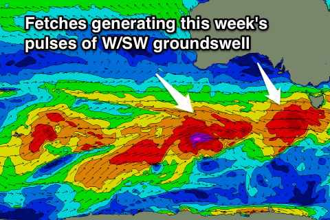
The long-range energy was generated in the south-east Indian Ocean and will be really inconsistent, but the shorter-range swell will be good consistent and moderate in size. This is being generated by a strengthening mid-latitude front pushing in from the west, with a fetch of gale to severe-gale W/SW winds being generated through our western swell window.
A late kick in size is due tomorrow to 3ft+ on the Surf Coast and 5-6ft on the Mornington Peninsula, peaking Wednesday morning to 3-4ft and 5-6ft+ respectively.
Another slightly stronger pulse of W/SW groundswell is due later in the day Wednesday, peaking Thursday morning from a secondary fetch of severe-gale to near storm-force W/SW winds moving in on the back of the initial front.
 This swell should provide better 3-5ft waves on the Surf Coast and 6-8ft sets on the Mornington Peninsula when it kicks late Wednesday, easing from this size Thursday morning and further Friday.
Looking at the conditions and NW winds will persist most of tomorrow, favouring the Surf Coast and then variable tending light local offshore winds Wednesday, swinging SE into the afternoon.
Thursday should be clean across most locations with a light N'ly breeze (hopefully tending N/NW on the Surf Coast) and then variable into the afternoon.
Fresh N'ly tending N/NW winds are then due on the backside of the swell Friday.
This weekend onwards (Jul 23 onwards)
During Friday we'll see a vigorous and deepening mid-latitude low pushing in from the west.
The latest 18z model updates have downgraded the strength of this system a little and also the longevity of each fetch within our swell window.
A short-lived burst of W'ly gales Friday morning should kick up a late increase in windswell but to no significant size, with a secondary burst of weaker strong to gale-force W/SW winds Friday evening and early Saturday producing a secondary kick for Saturday.
The Surf Coast isn't likely to get much over 3ft+ at this stage with 6ft sets on the Mornington Peninsula.
Strong NW tending W'ly winds are due Friday with Saturday seeing W/NW shifting W/SW winds favouring the Surf Coast. The backside of the swell Sunday will be better with NW tending N/NW winds.
Longer term some good W/SW groundswell is due into the following week, but more on this Wednesday.
Comments
00z update now has a storm-force fetch of W'ly winds pushing through Bass Strait Friday and with this we'll see much larger surf than forecast above later Friday and Saturday morning.
We'll see how updates playout overnight.
sounds like another Wly swell either way