Wednesday best of the week, Sunday next decent surf

Victoria Forecast by Craig Brokensha (issued Monday 11th January)
Best Days: Wednesday exposed beaches, Sunday east of Melbourne
Recap
A strong new pulse of SW groundswell came in as forecast on Saturday morning with inconsistent 3-4ft sets on the Surf Coast and 6ft to occasionally 8ft waves on the Mornington Peninsula, with light winds from the west, favouring the Surf Coast reefs.
The swell dropped back slowly through the day and further into Sunday from 3ft on the sets across the Surf Coast and 4-5ft+ on the Mornington Peninsula with better light E/NE winds for locations to the east of Melbourne.
Today a mix of long-range and inconsistent SW groundswell has kept 2-3ft sets hitting the Surf Coast with 3-5ft sets on the Mornington Peninsula under light offshore winds.
This week (Jan 12 - 15)
Today's inconsistent SW groundswell is expected to ease back into tomorrow but a shallow onshore change moving in through the night is expected to freshen around dawn from the S/SE, creating poor conditions.
Later in the day tomorrow a new kick of SW groundswell is due, peaking overnight and then easing back into Wednesday. This swell has been generated by a small mid-latitude low moving in from the Indian Ocean, with it currently just south-west of Tasmania.
The Surf Coast should kick to 2-3ft later tomorrow and ease from a similar size Wednesday morning, with 4-5ft sets on the Mornington Peninsula. Better NE to N/NE winds will favour the Mornington Peninsula and Surf Coast beaches Wednesday morning before a developing sea breeze and approaching front battle, possibly resulting in variable afternoon breezes.
 Thursday will be a good lay day as a fresh SW change is due to move in around dawn with small leftover amounts of swell during the morning.
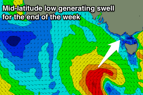
This change will be linked to a strong mid-latitude low moving in from the Bight, with it developing south-west of WA today.
A fetch of SW gales will be produced just on the edge of our western swell window before it drifts south-east while approaching Tasmania into our south-western swell window.
What should result is a moderate to large sized W/SW groundswell for Thursday evening/Friday, easing while veering more SW in direction Saturday. The Surf Coast should see solid 4-5ft waves, with 6-8ft+ sets on the Mornington Peninsula but with poor S/SW winds. There's an outside chance for an early W'ly around Torquay, but we'll have another look at this Wednesday.
This weekend onwards (Jan 16 onwards)
Friday's swell will ease back through Saturday but with lingering S/SE winds, creating average conditions.
Sunday will be much smaller but cleaner with NE offshores, favouring the Mornington Peninsula with easing 3ft sets.
Longer term a better SW groundswell is on the cards for Tuesday/Wednesday next week from a strong polar frontal progression firing up through the weekend, but more on this Wednesday.
Comments
How's that swell for next Tuesday/Wednesday looking Craig ?what size and wind is currently forecast. I no it's a bit far away but I am eager to know haven't been many good big swells this summer
Cheers mate
It's kind of disappeared, with the strong polar frontal progression now splitting resulting in a mid-latitude low off WA, and weaker activity in the Southern Ocean. The Eurpoean model still has something on the cards, but we'll have to wait for Friday at least for a clearer idea.
Pumping on the Bellarine this morning!