Window of better conditions Thursday then onshore again

Victoria Forecast by Craig Brokensha (issued Wednesday 26th August)
Best Days: Thursday morning both coasts, Monday and Tuesday mornings east of Melbourne
Recap
Poor easing surf across both coasts yesterday with moderate to fresh SE winds and today a good building SW groundswell that was 3-4ft on the Surf Coast already this morning but terrible with a fresh E'ly wind. The Mornington Peninsula was better with peaky 4-6ft waves under the E'ly breeze favouring selected locations.
The swell should reach 3-5ft on the Surf Coast and 6-8ft on the Mornington Peninsula as winds ease and likely tend a touch more N'ly.
This week and weekend (Aug 27 - 30)
We've had a win with conditions tomorrow, as a light variable breeze is now expected most of the day ahead of a mid-late afternoon S/SE change.
This will be due to a small embedded trough drifting south-west across our regions resulting in relaxing winds before drifting back to the east later in the day.
Today's SW groundswell should ease a touch but steady as a reinforcing pulse arrives through the afternoon keeping 3-4ft sets hitting the Surf Coast and 6ft+ waves on the Mornington Peninsula.
Come Friday conditions will be poor again with a moderate sized and easing SW swell with fresh to strong S'ly tending S/SW winds.
The weekend isn't looking any better with fresh S/SW tending W/SW winds Saturday with a small building S/SW swell, while Sunday is still unsure but likely to see SW tending S/SE breezes as an initial pulse of inconsistent long-range SW groundswell fills in.
 Next Monday onwards (Aug 31 onwards)
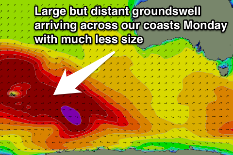
Sunday's initial increase in long-range SW groundswell will be the precursor to a stronger but similarly inconsistent SW groundswell for Monday. This swell is currently being generated in the southern Indian Ocean by a broad and elongated fetch of severe-gale to storm-force winds in our far swell window.
The system will generate a large long-period S/SW groundswell for Indonesia, but arrive across our coasts Monday and peak to a very inconsistent 3ft across swell magnets on the Surf Coast and 4-6ft on the Mornington Peninsula (easing late) under light E/NE tending SE winds.
Come Tuesday the swell will be on the way out with better N'ly tending E'ly breezes.
Longer term there's still nothing major on the cards with another cut-off low moving slowly through the Bight next week due to block our main swell windows, but we'll have a closer look at this and the weekend's winds on Friday.
Comments
Hi craig,
With the easterly winds expected on Sunday do you think there will be any options around the surf coast? Or will Phillip island be a better bet?
Go for a drive and find out :-)