Great weekend, average into early next week

Victoria Forecast by Craig Brokensha (issued Friday 29th May)
Best Days: Saturday and Sunday morning Surf Coast, early Monday and Tuesday for keen surfers around Torquay, both coasts Wednesday morning, east of Melbourne Thursday
Recap
Wednesday's long-range and inconsistent W/SW groundswell eased back through yesterday, with a new W/SW swell due to replace it not coming until later in the day. Instead the Surf Coast was a smaller 1-2ft with a strengthening offshore winds. While the Mornington Peninsula was in the 4ft range.
Today a strong and powerful W/SW groundswell expected to build through the day was a little slow at dawn and around 3-4ft on the Surf Coast, but it's since built strongly with 6ft sets across exposed breaks under a perfect offshore wind. The swell should build further through the day and reach 6-8ft into the afternoon as winds remain favourable. * On cue an 8ft clean-up set just rolled through Bells, viewed on the Australian Indigenous Surfing Titles webcast *
 This weekend and next week (May 30 – Jun 5)
This afternoon's large kick in large and strong W/SW groundswell is expected to ease back through tomorrow, but a reinforcing SW swell should slow this trend, generated on the backside of the low yesterday.
The Surf Coast should ease from 4-6ft with 8ft sets on the Mornington Peninsula under favourable and persistent N/NW tending NW winds.
Into Sunday a new W/SW groundswell should be visible in the morning to 3-5ft on the Surf Coast and 6-8ft on the Mornington Peninsula, generated tomorrow by a pre-frontal fetch of W/NW gales through our swell window today and tomorrow.
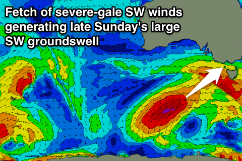
Behind this though, a fetch of severe-gale SW winds being projected up and into us tomorrow, generating another large SW groundswell pulse for Sunday afternoon, kicking to 6-8ft across the Surf Coast later in the day and 8-10ft on the Mornington Peninsula.
Conditions will be best through the morning and early afternoon though with a fresh NW tending W/NW breeze ahead of a SW change.
Into Monday the swell is expected to ease but conditions will be poor with a fresh to strong S/SW'ly, although an early W'ly breeze is a good chance around Torquay.
Tuesday will be smaller again and besides a possible early W'ly around Torquay, conditions will be average with a S/SW'ly.
Wednesday may see variable breezes as small and inconsistent S/SW groundswell fills in, generated by a small but intense polar low. The Surf Coast is due to ease from an inconsistent 2-3ft, with 3-5ft sets east of Melbourne.
Thursday will be best across exposed breaks and locations east of Melbourne with N/NE winds.
Longer term, a very inconsistent but strong long-range W/SW groundswell is due across the state, generated by a very strong and powerful frontal progression firing up in the Indian Ocean. The front isn't expected to push any closer than WA, with infrequent 3ft sets due on the Surf Coast at its peak next Saturday with 4-6ft waves on the Mornington Peninsula. More on this Monday though, have a great weekend!
Comments
thought for the day: ever feel like the night before never happened?
Poignant.
Anyway, would you consider this to be a well groomed swell event?