Plenty of swell, poor winds

Victoria Forecast by Craig Brokensha (issued Monday 23rd February)
Best Days: Wednesday for keen surfers in protected locations east of Melbourne, possibly early Thursday on the Surf Coast, Friday morning, Saturday morning east of Melbourne
Recap
Friday afternoon's kick in SW groundswell held well into Saturday morning with 3ft waves across the Surf Coast with the odd bigger 4ft set at Barwon Heads and 5ft+ waves on the beaches east of Melbourne under favourable and light NE winds.
Winds remained light nearly all day providing a good fun day of waves across both coasts.
Sunday was smaller but more manageable on the beaches east of Melbourne with fresh N/NE winds that remained offshore into the evening. The Surf Coast was also clean but much smaller before a shallow onshore change moved through mid-afternoon.
Today a new W/SW groundswell ahead of a stronger SW groundswell perked waves back up to the 2-3ft range on the Surf Coast and 4-6ft on the Mornington Peninsula and early offshores created clean conditions but a strengthening SW change has now moved through.
 This week (Feb 24 - 27)
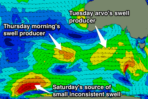
This afternoon we should see a strong but inconsistent pulse of SW groundswell across the state, reaching 3-4ft on the Surf Coast and 6-8ft on the Mornington Peninsula late but with these SW winds there'll be nowhere to surf.
A secondary pulse of more consistent W/SW groundswell should arrive through the afternoon tomorrow from a front currently pushing in from the west, halting the easing trend with the Surf Coast due to hold around 3ft+ all day, with 6ft to occasionally 8ft sets on the Mornington Peninsula.
Conditions will remain poor with fresh S'ly tending S/SE winds, favouring only a select few locations state wide.
Wednesday should see the W/SW swell start to ease and winds will remain poor for the Surf Coast and strong from the E/SE, kicking up some junky windswell for the afternoon. More options should open up to the east of Melbourne with winds likely to tend straighter E'ly through the day.
Into the end of the week a couple of smaller W/SW pulses are due into Thursday and Friday from a couple of weak mid-latitude fronts dipping under the country today and tomorrow. The strongest on Thursday morning should keep 2-3ft sets hitting the Surf Coast and 4-6ft waves on the Mornington Peninsula before easing Friday.
Local winds are the only issue with an inland surface trough leading to funky and tricky conditions. They're likely to be least favourable Thursday and from the W turning S/SE, while Friday morning should see more variable breezes.
This weekend onwards (Feb 28 onwards)
There's nothing too significant on the cards for the weekend but winds should be favourable early Saturday for exposed breaks across the state as a very distant and infrequent south-west swell fills in. An afternoon change associated with a trough pushing in from the west will create poor conditions that will persist into Sunday.
The longer term outlook is better with another strengthening node of the Long Wave Trough due to move in this weekend resulting in some better swell activity next week, but we'll have a closer look at this on Wednesday.