Lots of swell on the way

Victoria Forecast by Craig Brokensha (issued Wednesday 24th December)
Best Days: Both regions tomorrow morning, dawn around Torquay Friday, Saturday morning Surf Coast, Sunday morning east of Melbourne, Monday morning both coasts
Recap
Yesterday was clean and fun across the Mornington Peninsula early as well as the Surf Coast before a strong onshore change moved through mid-afternoon.
Today a further lift in swell has been seen across both coasts to 2-3ft on the Surf Coast and 4-5ft on the Mornington Peninsula but with lingering onshore winds. We should see the swell kick further during the day to a more consistent 3ft and 5-6ft respectively as winds swing more S-SE.
 This week and weekend (Dec 25 - 28)
This afternoon's increase in SW groundswell should peak tomorrow morning across both coasts, generated by a strong cold front projecting towards us over the last few days from the south-west of WA.
There's no change to the expected size with good 3ft+ sets due across exposed breaks on the Surf Coast and 6ft+ waves on the Mornington Peninsula.
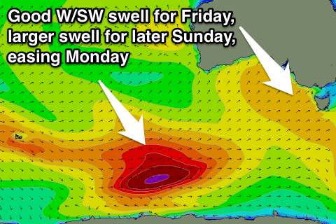
Friday's pulse of reinforcing swell looks to be a touch bigger now and with a touch more west in its direction. This is a result of the secondary front producing this swell generating a better fetch of W/SW gales through our western swell window last night and early this evening.
A strong pulse of W/SW groundswell should peak Friday morning from this source coming in at 3-4ft on the Surf Coast and 6ft to occasionally 8ft on the Mornington Peninsula before easing during the day and down further from 3ft and 6ft on the sets respectively Saturday morning.
Winds should improve tomorrow and become variable during the morning but likely still be just a light onshore across the Mornington Peninsula. The Surf Coast should see a light W/NW'ly through the morning before swinging onshore from the SW later morning and then freshening.
Friday morning will only offer a very short and small window of good conditions across the Victorian coast and this will be around Torquay with a W/NW'ly at dawn. Everywhere else will be poor with fresh to strong SW winds, with the onshores overcoming local effects around Torquay mid-morning 8-9am.
Saturday will be much better for a longer period with W/NW-NW offshore across the Surf Coast, while the Mornington Peninsula will still be bumpy.
A low point in swell activity is due Sunday morning but it will only be short-lived as a strong pulse of new SW groundswell is due to arrive through the day and peak into the evening.
This will be generated by a significant polar frontal system firing up from just east of Heard Island this afternoon, projecting a fetch of W/SW gales perfectly up towards us over the coming days. A moderate to large sized SW groundswell will be generated, reaching 3-4ft+ across the Surf Coast later Sunday and 6-8ft on the Mornington Peninsula.
Winds will be OK for the Mornington Peninsula before the swell kicks and from the E/NE but into the afternoon conditions will be average with S/SE sea breezes.
Next Monday onwards (Dec 29 onwards)
Monday is looking excellent with Sunday's kick in swell expected to ease back slowly from 3-4ft and 6ft to occasionally 8ft respectively under early local offshore winds before freshening from the NW ahead of a strong and late W/SW change.
The change will be linked to a secondary vigorous polar front projecting up towards us on a similar track as the system before, but without as much strength.
A secondary moderate to large W/SW groundswell should result, building to 3-5ft and 6-8ft respectively Tuesday afternoon but with strong onshore W/SW winds.
Wednesday will be the pick as winds revert back to the W/NW through the morning and the swell eases, but more on this Friday.