Plenty of swell all week but with dicey winds

Victoria Forecast by Craig Brokensha (issued Monday 22nd December)
Best Days: Early Tuesday Mornington Peninsula, all morning Surf Coast, Thursday morning both coasts, early Friday around Torquay, Saturday morning Surf Coast
Recap
The weekend saw small clean waves across the Surf Coast each morning mainly in the 2ft range, while the Mornington Peninsula was bumpy and average Saturday and better Sunday with an easing 3-4ft of swell and peaky conditions under an E/NE breeze.
Today the swell has bottomed out and winds lingered onshore from a change yesterday afternoon, creating poor conditions everywhere.
 This week (Dec 22 - 26)
A slight and small lift in SW groundswell is due today, holding into tomorrow morning but only a 2ft wave is due on the Surf Coast, while the Mornington Peninsula should see 3-4ft+ sets.
Conditions should be nice early across both coasts with local offshores but a swing to the NW is due mid-morning and then W/NW around lunch ahead of a gusty W/SW change. So if you want to surf on the Mornington Peninsula, the early will be the go.
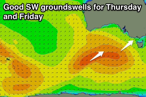
Our run of better SW swell through the middle to end of the week and beyond is shaping up nicely.
A series of broad and relatively strong polar fronts are pushing through the Southern Ocean from the south-west of WA up under the country and towards us before weakening on our door step.
Various pulses of SW groundswell are due from this progression, the first arriving through Wednesday, building from 2-3ft on the Surf Coast and 4-6ft on the Mornington Peninsula to a more solid 3ft and 5-6ft respectively during the afternoon.
The strongest pulse looks to be Thursday, followed by a secondary similar pulse Friday to 3ft+ at exposed breaks on the Surf Coast and 6ft+ on the Mornington Peninsula.
Winds are unfortunately will be onshore from the S/SW tending S/SE on Wednesday but without too much strength, and then Thursday is a little funky with a light variable breeze expected around dawn before freshening from the SW during the day as a weakening cold front pushes in from the west.
Early Friday looks like the best window surf, with an early W/NW'ly likely around Torquay favouring the protected reefs. We'll confirm this Wednesday though. Onshore winds will be blowing everywhere else though from the SW, and these will develop mid-morning around Torquay.
This weekend onwards (Dec 27 onwards)
We'll see Friday's good pulse of swell drop away through Saturday but under favourable NW winds for the Surf Coast through the morning with clean 2-3ft waves expected.
The next succession of cold fronts will fire up later this week and into the weekend producing another good round of SW groundswell from Sunday through Thursday next week. Size wise we're looking at peaks in the similar 3ft+ and 6ft+ range respectively for both coasts with favourable light winds each morning. We'll have a closer look at this on Wednesday though.