Poor weekend and start to next week, better from Friday

Victoria Forecast by Craig Brokensha (issued Friday 5th December)
Best Days: Monday morning selected spots west of Melbourne, later next week and next weekend
Recap
The Mornington Peninsula and Phillip Island were the pick yesterday morning with clean and peaky 3ft or so of swell under light E/NE winds before onshores crept in mid-late morning. The Surf Coast was tiny but glassy for most of the morning, and a funky sea fog developed into the mid-afternoon.
Today we're starting to see the effects of a slowly deepening surface trough to our north-east with onshore S/SE winds and small to tiny amounts of swell which are now deteriorating with a fresher SE'ly.
 This weekend (Dec 6 - 7)
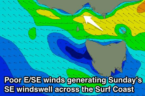
The weekend will be very poor as the trough continues to deepen directing strengthening E/SE winds into both coasts tomorrow, becoming strongest into Sunday morning.
This will kick up a junky SE windswell across the Surf Coast tomorrow afternoon, peaking through Sunday to 3ft+ across the Surf Coast (smaller east of Melbourne). If you're really desperate for a surf this will be the day to do it with junky windswell beachies across the Surf Coast the go.
Next week onwards (Dec 8 onwards)
The trough will weaken and slip south-east into Sunday evening resulting in the windswell backing off from 2-3ft and winds swinging around to the SW, and this will open up a couple of locations across the Surf Coast for savvy surfers Monday morning.
A new small SW groundswell is due on the Mornington Peninsula to 3-4ft but conditions will be terrible.
Unfortunately we'll continue see onshore winds into Tuesday and Wednesday that will really strengthen into the latter.
A new SW groundswell is due Wednesday from a strong polar low, kicking to 2ft+ through the day on the Surf Coast and 4-5ft on the Mornington Peninsula but the onshore winds will spoil this.
Into the end of the week and weekend things are finally looking up, with some stronger polar frontal activity due to fire up south of the country during next week, and winds should kick around to the E/NE-NE as it arrives on Friday and Saturday.
The only issue is that the size looks possibly a touch too big at times for the Mornington Peninsula, coming in at 5-6ft or so Friday afternoon and Saturday morning, but we'll review this again Monday. Have a great weekend!
Comments
Seems to be onshore and junky carp for as far back as the mind's eye goes. Some interesting SE swells in the water, tho; always spins me out to see the coast break as if it were driving on the wrong side of the road. I've seen weird swell angles on both sides of Bass Straight and you can get waves you would never imagine. Some of them were even offshore!
Yeah if I was on the Surf Coast today I'd be getting stuck into the windswell. Love those sizey junky swells, so many waves, super consistent and good for your surfing as you have to react quick and on the fly. Also gives you a good cardio work out paddling back out.