Plenty of swell but limited windows for good conditions

Victoria Forecast by Craig Brokensha (issued Monday 29th September)
Best Days: Tuesday, possibly early Wednesday around Torquay, Thursday morning around Torquay, Friday for keen surfers, Saturday
Recap
The weekend started off great with a clean and easing 3ft of swell across the Surf Coast and clean 6ft waves on the Mornington Peninsula which became more user friendly into the afternoon as the Hawks smoked the Swans.
Sunday was tricky with a strong to gale-force offshore wind and small fading swell on the Surf Coast and bigger but blowy 3-4ft waves on the Mornington Peninsula.
Today an acute increase in W/SW groundswell was a little slow going at dawn but has since kicked to a bigger 2ft+ around Torquay with the odd bigger one at 13th Beach and larger but bumpier waves on the Mornington Peninsula under the fresh to strong W/NW breeze.
This week (Sep 29 – Oct 3)
 Today's initial increase in acute W'ly swell should reach 3ft at exposed spots across the Surf Coast through the day and 6ft+ on the Mornington Peninsula as winds tend variable from the NW.
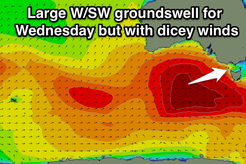
This swell should hold into tomorrow morning to a similar size before pulsing late with the arrival of a new W/SW groundswell that's expected to peak Wednesday.
This is being generated by a broad and strong polar front that's currently south of the WA, moving slowly towards us while generating a fetch of W/SW gales.
A large W/SW groundswell will result, peaking Wednesday morning to 5-6ft on the Surf Coast and 8ft+ on the Mornington Peninsula ahead of a drop in size into the afternoon and further down from 3-5ft and 6ft to occasionally 8ft Thursday morning.
Winds will be a bit of an issue with strengthening NW winds ahead of a late and strong W'ly change tomorrow, while Wednesday now looks poor as winds swing SW overnight and remain there into the morning. They should ease and swing more W/SW through the day, but the damage will be done. There is an outside chance for an early W'ly around Torquay but it will be far from perfect.
Thursday will be the day to surf with winds swinging back to the W/NW through the morning before returning to the W/SW before lunch.
As we move into the end of the week, another strong kick in swell is expected, arriving from the S/SW and peaking through the day Friday.
This swell should be generated by a very intense polar low firing up south-west of Tassie, late in our swell window, aiming a fetch of severe-gale to storm-force SW winds through our southern swell window as the low pushes north-east towards New Zealand (producing a very large swell for that country and then Cloudbreak next Monday).
We should see medium-large levels of S/SW swell spreading radially up towards us, peaking before lunch on Friday to a strong 3-5ft on the Surf Coast and 6-8ft on the Mornington Peninsula.
Winds look to be an issue again though as an overnight change and ridge of high pressure moving in Thursday evening results in onshore winds from the S'th to SE. There won't be much strength in the onshore, so selected spots should be OK for keen surfers.
This weekend onwards (Oct 4 onwards)
Saturday should see winds swing back offshore again across both coasts from the N'th as the S/SW swell eases steadily. The Mornington Peninsula will probably be a touch too big while the Surf Coast will ease from the 3ft range.
Come Sunday the swell will bottom out with early N/NW tending strong W/SW winds.
Longer term there's a couple of swells on the cards for next week but nothing too major or standout. Check back here on Wednesday for the latest on this though.