Best Friday and Sunday mornings

Victoria Forecast by Craig Brokensha (issued Wednesday 13th August)
Best Days: Friday morning, Sunday morning
Recap
A dropping swell and fresh to strong onshore winds yesterday left no real decent options for a wave, while today lighter onshore winds made the surf a little appealing but there wasn't much size around.
This week and weekend (Aug 14 - 17)
Our run of poor conditions will continue into tomorrow with a persistent S/SW wind across the coast, but a new SW groundswell should fill in, to 3ft+ on the Surf Coast and 5-6ft on the Mornington Peninsula.
Friday will finally see winds swing back offshore, and a reinforcing SW groundswell should continue to provide medium sized waves across both coasts during the morning. A light N/NW'ly is due on the Surf Coast, while the Mornington Peninsula should see a straighter N'ly during the morning, with weak onshore winds due across both coasts into the afternoon.
 Saturday morning won't be as nice but still workable with a light variable wind and small leftover swell to 2ft on the Surf Coast and 3-4ft on the Mornington Peninsula.
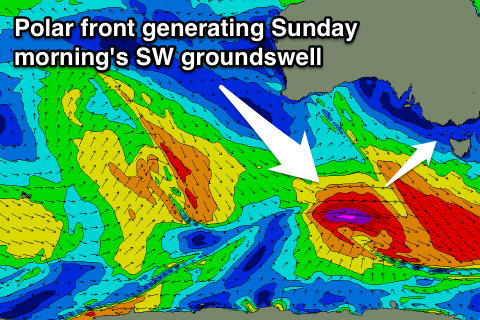
A new SW groundswell is due Sunday morning, generated by a polar front firing up to our south-west Thursday and Friday and aiming a fetch of severe-gale W/SW winds through our south-west swell window.
A moderate sized SW groundswell should result, peaking Sunday morning to 3ft+ on the Surf Coast and 5-6ft on the Mornington Peninsula, but a deep inland surface trough moving off the East Coast will continue to produce funky winds. An early light variable breeze is likely but this will strengthen from the S/SW during the day, so surf early for the best conditions.
Next Monday onwards (Aug 18 onwards)
The trough moving offshore of the East Coast during Sunday is expected to form into a low pressure system early next week and stall in the Southern Tasman Sea. This will unfortunately see strengthening onshore winds developing across the region again from the lows western flank, kicking up medium to large levels of windswell in the process. There'll also be a medium sized SW groundswell for Monday afternoon but with the strengthening onshores, conditions will be a write-off.
The low should move off to the east through the middle of next week resulting in improving winds across the coast, probably from the E/NE tending N'ly. More on this on Friday though.