Large and easing over the weekend, great Tuesday/Wednesday

Victoria Forecast by Craig Brokensha (issued Friday 1st August)
Best Days: Thursday morning, Friday, early Saturday, Sunday, Monday
Recap
Wednesday's solid pulse of W/SW groundswell dipped back into yesterday to 3-4ft on the Surf Coast and 6ft+ on the Mornington Peninsula but conditions were extremely tricky and almost unsurfable with a gale-force N/NW breeze.
A late kick in longer-range SW groundswell was seen though and this has peaked this morning to 4-6ft around Torquay, while other locations like 13th Beach failed to really pick up any major size. The Mornington Peninsula was large and average as fresh to strong W/NW winds favoured the Surf Coast reefs.
This swell should hold for most of the day ahead of a late kick in larger W/SW groundswell but winds will be poor and swinging onshore from the S/SW.
This weekend (Aug 2 - Aug 3)
This evening's late kick in W/SW groundswell has been generated by a vigorous polar front projecting up from the polar shelf to the south-southwest of WA, into SA, generating large SW swells for that state.
This system was just within our swell window and should produce a large W/SW groundswell for later today, peaking overnight and easing tomorrow morning from 6ft across the Surf Coast with bigger bombs possible at swell magnets, while the Mornington Peninsula should ease from 10ft+.
Winds will be poor and fresh but easing from the SW tending W/SW, but the Torquay region is more than likely to see an early W'ly breeze, creating workable conditions on the protected reefs.
Sunday will be much cleaner and a reinforcing SW groundswell should halt the size from dropping below 3ft into the afternoon across the Surf Coast and 5-6ft on the Mornington Peninsula under fresh N/NW tending lighter NW winds. The Mornington Peninsula may even see straighter N'ly winds through the morning.
Next week onwards (Aug 4 onwards)
Monday morning is expected to become a low point in swell activity with 2ft leftovers across the Surf Coast and 3-5ft waves on the Mornington Peninsula under N/NW tending W/NW winds.
A late kick in new W/SW groundswell may be seen but Tuesday will be a better day to surf.
A couple of medium sized W/SW and SW groundswell pulses are due to a strong frontal progression moving in from the Indian Ocean, firing up to our south-west during Saturday evening, Sunday and Monday morning.
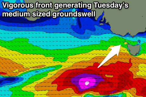 The strongest pulse is due Tuesday, arriving late Monday and providing 3ft sets on the Surf Coast with 6ft waves to the east, peaking in the 3-5ft and 6-8ft range respectively from midday Tuesday into the afternoon. A secondary reinforcing pulse for Wednesday should keep 4ft sets hitting the Surf Coast and waves above 6ft on the Mornington Peninsula before easing slightly later.
Winds will strengthen from the NW to W/NW Tuesday and then become stronger into Wednesday, favouring protected spots west of Melbourne.
We could see another medium sized groundswell for Thursday but we'll look into this in more detail on Monday. Have a great weekend!