Great from Sunday onwards

Victoria Forecast by Craig Brokensha (issued Friday 11th July)
Best Days: Early Saturday around Torquay for keen surfers, Sunday morning, Monday, Tuesday, Wednesday, Thursday
Recap
A good pulse of long-range W/SW groundswell came in as expected yesterday with the Surf Coast lifting to 3ft to occasionally 4ft with morning offshores, while the Mornington Peninsula was larger but a write-off with strong onshores.
Today the swell has dipped back quicker than expected to a smaller 2ft+ (3ft+ at Barwon) with straighter offshore winds west of Melbourne and 4-5ft across the Mornington Peninsula with early light N'ly winds. The swell should continue to ease through the day as winds persist from the N/NW.
This weekend (Jul 12 – 13)
There's been no change to the large SW groundswell due to fill in tomorrow across the state, with a rise in size from 3-4ft to 4-6ft due across the Surf Coast into the late afternoon, with the Mornington Peninsula rising to 6-8ft+ late.
Tomorrow conditions will be average though with only a brief period of W'ly winds expected around Torquay, with fresh and gusty SW winds everywhere else.
Sunday is still looking the best as a reinforcing SW groundswell from tomorrow's front keeps 4-5ft waves hitting Torquay through the early morning, before dropping through the day under morning W/NW winds. A shift to the W/SW is due into the afternoon but probably around 1-2pm.
Next Monday onwards (Jul 12 onwards)
The swell will continue to drop from the weekend into Monday, but the easing trend will be softened by another weak polar front pushing through our swell window on Saturday evening and Sunday.
This should keep 3ft sets hitting the Surf Coast while the Mornington Peninsula should ease from 6ft or so across open beaches and winds will be great, swinging locally offshore across both coasts before tending E/NE into the afternoon.
This will be the day to hit up spots east of Melbourne.
As touched on last update, we'll see moderate sized pulses of W/SW groundswell pushing through from Tuesday through until Thursday as a strong node of the Long Wave Trough pushes in from the Indian Ocean and then across to us the middle of next week.
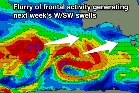 With this a flurry of polar fronts should push through our western swell window before moving more into our south-west swell window through the end of the week.
At this stage we're looking at some fun W/SW groundswell pulses, the first arriving through Tuesday and building to 3ft and 6ft respectively across both coasts, with Thursday likely to see an even stronger pulse.
Winds will be good for the Mornington Peninsula Tuesday with a fresh N/NE breeze, but from here on winds will swing from the N/NW to NW through Wednesday and Thursday. Into the end of the week when the large swell is due, winds look less favourable but we'll review this Monday. Have a great weekend!