Good waves through the coming period, best Sunday

Victoria Forecast by Craig Brokensha (issued Wednesday 9th July)
Best Days: Thursday morning, Friday, early Saturday, Sunday, Monday
Recap
The surf backed off a touch into yesterday with a new W/SW groundswell failing to really show, with small clean 1-2ft waves across the Surf Coast and better 4ft sets on the Mornington Peninsula during the morning. A slight kick in size was seen through the afternoon on the Surf Coast's exposed beaches, but this has eased back into today with tiny waves left across the region. The Mornington Peninsula had 2-3ft sets but this morning's clean conditions will become chopped up into this afternoon as winds swing W/NW. A slight kick in size may be seen later in the day, but tomorrow will be much better.
This week (Jul 9 – Jul 11)
Tomorrow's long-range W/SW groundswell is still on track, but the additional short-range W/SW swell has been wiped with the mid-latitude front pushing in from the west staying just north and out of our swell window.
With this, we're expected to see just the inconsistent W/SW groundswell generated over near WA pushing in and offering inconsistent 3ft to occasionally 4ft waves across exposed spots on the Surf Coast and 6ft to occasionally 8ft sets on the Mornington Peninsula.
Winds will be favourable for the Surf Coast through the morning and offshore from the W/NW but the afternoon will become poor as a fresh to strong SW change moves through.
A slow drop in size is expected through Friday from 3ft or so west of Melbourne and 6ft to the east and conditions should remain clean all day around Torquay with strengthening NW tending W/NW winds.
This weekend onwards (Jul 12 onwards)
The weekend's large SW groundswell is still on track and winds are now looking more favourable than they were on Monday.
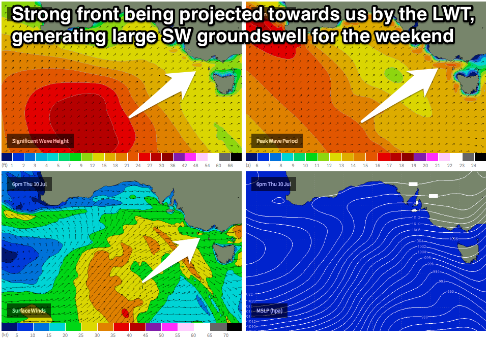 The formation of this swell is linked to a strong but weakening amplification of the Long Wave Trough moving across south-eastern Australia later this week.
With this a vigorous polar front is being steered up towards us under the influence of the LWT, projecting an initial broad but slowly weakening fetch of SW gales up towards us from yesterday right through until Friday evening.
Size wise, we should see the Surf Coast building to 4-6ft through Saturday afternoon, from a smaller 3-4ft during the morning, with the Mornington Peninsula coming in at 6-8ft+.
Besides an early period of W'ly winds around Torquay Saturday morning, a fresh SW change will create poor conditions as the swell fills in, but Sunday on the other hand looks great with a secondary reinforcing frontal system moving in, swinging winds back to the W/NW and persisting most of the day.
This front should also slow the easing trend, with the Surf Coast expected to only drop slightly from 4-5ft Sunday morning as the Mornington Peninsula eases a touch from 6-8ft.
Monday looks great as well as moderate amounts of SW swell persist in the 3ft to sometimes 4ft range early west of Melbourne with 6ft sets to the west under N/NW tending variable winds, opening up lots of options across the state.
Longer term we've got a flurry of medium to large sized W/SW groundswells on the cards for next week as a new node of the Long Wave Trough pushes in through early to mid next week. Winds through the initial stages of these swells (kicking in Wednesday onwards) look favourable but we may see onshores with the largest pulses of size later in the week. More on this in Friday's notes though, as there's plenty in store over the coming days.