Poor weekend, better next week

Victoria Forecast by Craig Brokensha (issued Friday 6th Jun)
Best Days: Monday, Tuesday and Wednesday morning on the Mornington Peninsula, Thursday on the Surf Coast
Recap
A medium sized W/SW groundswell filled in through yesterday and Torquay performed the best with a morning W'ly that flirted onshore through the early afternoon before backing off again late and swinging offshore.
Today the swell was much cleaner with 3ft waves persisting across the Surf Coast, while the Mornington Peninsula offered larger and workable 4-6ft waves with a variable breeze. Winds should pick up from the W/NW during the day ahead of a fresh afternoon W/SW change and drop in swell, so get surfing now.
This weekend (Jun 7- 8)
There's been no change to the average looking weekend ahead, with early tomorrow around Torquay expected to be the only clean period of waves, but the swell will be small. A fresh W/NW wind will give way to a strong S/SW change before lunch and with this a medium sized increase in SW groundswell is due to follow and peak Sunday morning.
Winds will remain poor though with a fresh but easing S/SE breeze that may become light into the afternoon, so the late session Sunday may reveal some OK surf for desperate surfers.
Next Monday onwards (Jun 9 onwards)
Monday is now looking a lot better with a ridge of high pressure moving in quickly from the west resulting in winds tending around to the E/NE, creating good surf on the Mornington Peninsula. Size wise the Mornington Peninsula should ease from 4-5ft with 2ft+ sets on the Surf Coast (up to 3ft at 13th Beach).
Tuesday should be cleaner on the Surf Coast as winds swing around to the N/NW locally but there isn't expected to be much size left above an inconsistent 1-2ft while the Mornington Peninsula should offer good clean 3ft sets.
As touched on Wednesday, we'll finally start to see a better winter frontal progression firing up through next week as a node of the Long Wave Trough strengthens across south-west WA and pushes east towards us.
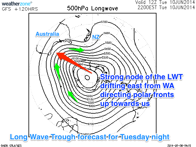 This will in effect steer and strengthen polar fronts up from the Heard Island region initially towards WA before focussing the attention further east and towards the Bight (illustrated right).
Initially medium sized levels of W/SW groundswell are due to start filling in from Thursday before clocking more SW in direction into next weekend and possibly becoming bigger.
It's too hard to lock down the sizes of each pulse at this early stage, but Thursday and Friday are likely to be in the 3ft range across the Surf Coast and 6ft on the Mornington Peninsula with more size likely into the weekend. Winds should be favourable for the first half of this event but may turn for the worst through the peak of the swell, but we'll provide another update on later next week and the weekend on Monday. Have a great weekend!
Comments
Hi Craig,
Seabreeze (Melbourne) is showing the swell period jumping up today with roughly the same wave height tomorrow morning as there was today - will this not bend some more (or at least the same) amount of swell into the surf coast?
Leckiep,
Just having a quick look at sea breeze and it's really hard to decipher what's going on there.
But if you look at our advanced tab or the swell train breakdown below the graph you will see that the extra large long period swell that arrives through this morning has no major size to it at all.
Starts at 0.2m at 25s and reaches a peak of 1.1m @ 18s tomorrow morning. This swell was generated under South Africa and will be super super super inconsistent and probably won't offer any major size above 1-2ft.
But looking at today's swell which was around 2.6m @ 12.7s at midnight last night, and that will drop over 1m in size by tomorrow morning and also loose 2s in period. This is the current swell on the way out.
So I wouldn't expect anything above 2ft tomorrow morning sorry.
Swellnet:

Seabreeze:

Thanks, that's super helpful!
I generally glance at seabreeze for a quick overview but read the notes here for more detail. They've changed something about their swell algorithm recently though and I'm yet to figure it out again.
Cheers
Thats awesome Craig, love your well explained Seabreeze graph at the bottom.
"False expectation on swell increase due to poor data representation"
Do you guys know the other forecasters for Seabreeze and beyond...?
You must do eh, have annual swell forecast piss up/meeting's with each other and give each other a good ol dig in the ribs.
I'm sure old mate from Seabreeze would read that....! Pretty funny, good marketing.
Seabreeze don't have any 'forecasters' Welly - they just punch out the raw NOAA data.
There's not many surf forecasters in the world, but I did meet with Sean Collins a few years back (in Sydney) and kept in contact with him up until he passed away. I've met up with a few others in my travels over the years, but as far as I know there's no Annual Surf Forecaster's Convention... if there was I imagine it'd be a pretty boring place though!
Thanks Ben was just wondering about that whole spectrum :)
A good mate in WA swears by Seabreeze...? Why I say to him! a site named seabreeze for surf forecasts, compared to swellnet haha.
The thing that grabs me with your guys forecasts is how passionate you are, as well as trying to meet the needs of the average Joe that you don't know. Cheers fellas.
How about this... The spike in size on SB is windswell. It's not displayed because it only shows peak period and sea height, not swell

Yeah exactly, but how as a user are you supposed to tell how much windswell/groundswell are in the mix. You can't that's why this forecast is so basic that it's unusable for surfing.
There should be an annual surf forecasters conference....maybe on North Shore in February every year... $1000 a head. I'll organise the speakers. Anyone keen?? I can send my bank account details to organise deposits..
Like Ben said MF, could be a tad boring.
Then again if you're organising it........?
Also I suggested an emergency surf forecasting conference in Java this week but was met with a resounding no haha
Is that because the office coffee runner!! can't have his immediate call for a good time away from being a coffee servant and organising surf forecast conferences ....??
Just trying to piece together those photos of the great waves you featured in, a few months back down south with Craigs comments ;)
I'll do a Sheepio now! hehehe :)
" I can send my bank details to organise deposits " Classic.