One day of decent waves on the way
Wednesday, 22 March 2023
One day of decent waves on the way
Wednesday, 22 March 2023
Average waves are expected to finish the week though the trend will be up, which is good.
Average waves are expected to finish the week though the trend will be up, which is good.
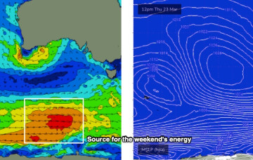
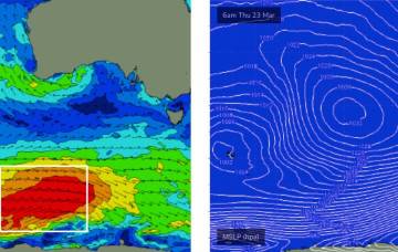
In the Coral Sea a monsoon trough remains active with a persistent but unspectacular trade-wind flow maintaining a small fun E swell signal north from Port Macquarie. The remnants of a low near the South Island are now dissipating after a final flare up yesterday.
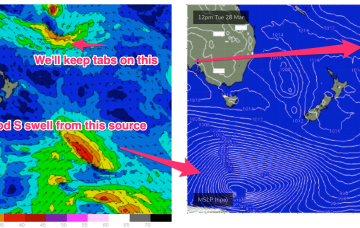
High pressure has now moved into the Tasman, weakening rapidly as it does so. In the south a small trough of low pressure off the Gippsland coast is aiding a N-NE flow through temperate NSW. In the Coral Sea a monsoon trough remains active with a persistent but unspectacular trade-wind flow maintaining a small E swell signal. The remnants of a low near the South Island are now dissipating after a final flare up yesterday.
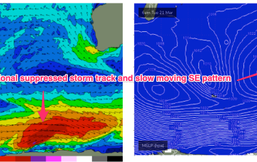
This “stuck” synoptic pattern will favour semi-protected waves in the SW under a regime of small SW pulses this week, generated by a zonal suppressed storm track, augmented by some smaller, long range WSW swell generated in the far western Indian Ocean.
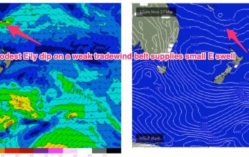
Tradewinds have been active through the Coral Sea, anchored by a small E’ly dip SW of New Caledonia. With the tradewinds fully established we are seeing a fully developed sea state through the Central/Southern Coral Sea which will keep fun waves chugging along through this week.
A trough in advance of a strong high pressure cell and deeper Southern parent low is bringing a fresh S’ly flow to Eastern Tas today, with conditions rapidly shifting gears tomorrow as the large high drifts East of the state.
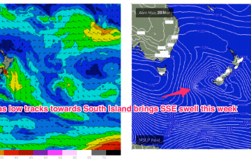
Compared to Fridays notes the front/low in the Southern Tasman is a stronger system while the tradewind pattern is weaker and more disjointed. That will see S quadrant swells dominate through most of the week through temperate-sub-tropical NSW, with a smaller tradewind swell signal north of the border being the dominant swell train.
Early Tuesday still has a brief window of options for keen surfers.
It’s a real shame about these local conditions, because there’s plenty of swell due on Tuesday at least, sourced from an active frontal progression late last week and into the weekend.
Looks like a poor couple of days ahead for the Torquay region, mainly due to local winds.