One day of decent waves on the way

Victorian Surf Forecast by Ben Matson (issued Wednesday 22nd March)
Features of the Forecast (tl;dr)
- Small surf early Thurs, slowly building towards a peak Sun with solid waves expected for the early session
- E'ly winds Thurs tending S'ly Fri/Sat
- Variable winds Sunday with the best conditions of the forecast period
- Easing surf and light winds Mon, reinforcing pulse Tues, though with tricky winds
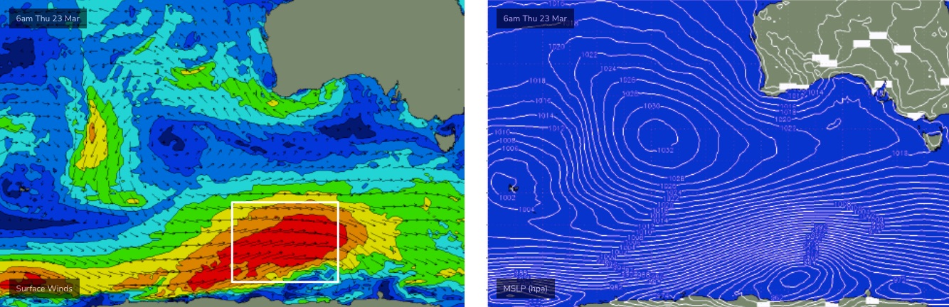
Recap
Although easterly winds were clocked as high as 40kts on Tuesday morning (South Channel Island, Point Londsdale), observations at most surfing regions were much less, and we actually saw winds become light and variable at a few locations through Tuesday afternoon, allowing for a period of workable waves. Today’s seen light winds through the morning but SE breezes are now freshening. Wave heights eased from 3ft+ to 2ft west of Melbourne, with 4-6ft surf east of Melbourne easing back to about 3ft.
This week (Mar 23 - 24)
Average waves are expected to finish the week though the trend will be up, which is good.
First of all, local winds are looking to swing slowly from the east to the south as a trough weakens over the state. Wind speeds shouldn’t amount to much but it’ll certainly be enough to take the sheen off surface conditions both days (Surf Coast) and Friday (MP/Island).
As for surf, a series of overlapping swell trains will start to filter in on Thursday morning with a gradual increase then expected over the coming three days. Early Thursday should kick off with occasional though clean 2-3ft sets east of Melbourne (1-2ft west of Melbourne) but size should muscle up by another foot into the afternoon, with a further increase expected through Friday.
It's likely that Friday may become a little too big for the open beaches east of Melbourne, though it’ll conversely remain undersized for protected spots, however we should see some 3ft sets by Friday afternoon across the Surf Coast reefs under a moderate onshore breeze. Don’t get your hopes up for anything amazing.
This weekend (Mar 25 - 26)
There’s been a slight improvement for the weekend outlook; that is Saturday should see gradually easing onshore winds and by Sunday we should be under a light variable pattern. Certainly not as good as any form of synoptic offshore, but still worth a surf.
The bulk energy from the upcoming Southern Ocean sequence will build further into Saturday, reaching a peak on Sunday, and as it’ll be sourced from a strong though low-latitude fetch (see below), swell direction should be straight SW, allowing an efficient spread into most coasts.
At this stage Saturday’s looking to build into the 3-4ft range west of Melbourne (4-6ft to the east) with a smidge more size by Sunday morning (say, 4-5ft and 5-6ft+ respectively) before size eases back into the afternoon. Sunday is well worth you attention.
Next week (Mar 27 onwards)
Easing swells are expected from Monday onwards, however the latest model runs have added a small polar low flaring up south of WA on Saturday that looks like it’ll just brush the eastern periphery of our S/SW swell window, leading to a kick in new swell on Tuesday morning. No major size is expected but we can expect some 3ft sets along the Surf Coast from this source. Early outlook is that local winds look iffy to accompany this pulse though.
Another front trailing behind is expected to shear off the storm track and become a cut-off low below the continent early in the week, though only small in size. This may lead to a SW wind change around Wednesday and subsequent pulse of small swell shortly thereafter.
There’s a few other systems sitting in the long range charts that should produce swell for the longer term, but in general the pattern looks a little lacklustre for this time of the year, so the general expectation for the second half of next week leading into the weekend is for low swells and average surf conditions.
I’ll have more in Friday’s update.
Comments
A little lacklustre longer term hey. Unfortunately we’re used to it.
how come the seabreeze was so strong this arvo? land temp would be hardly any different?
Probably more related to the tightening pressure gradient between the high over the Tasman Sea and a trough over western Victoria (which triggered this morning's thunderstorms). So a synoptic scale reason rather than a local/mesoscale one (i.e. sea breeze). Although there may have also been a sea breeze circulation contributing to the strength of the afternoon winds.
Cheers zadders. How about the 10 knot WNW at SC and the 20 knot seabreeze on the back beach right now. A classic.
Hmmm. Early autumn promised so much. Interesting to see if the Bells Pro can kick Huey back into gear like last year.
Last few years of the comp I think it was looking pretty dire just before but then miraculously pumped for at least parts of it.
Wasn't terrible today, glassy with lunps for the most part and some good head high waves.
Craigos the forecaster, a true legend of the sea,
With predictions so spot-on, he's loved by you and me.
Surfers trust his every word, and heed his every call,
For when Craigos speaks, the waves will rise, and that's not all.
But then there's Ben, who always puts his forecasts out late,
Surfers wait in frustration, and often show their hate.
His predictions are off the mark, and never quite on point,
No one really trusts him, and that's the honest point.
So here's to Craigos, the king of surf forecasting,
With skills so sharp and accurate, he's truly everlasting.
And as for Ben, well, we'll just have to wait and see,
If he can up his game, and be the forecaster he should be.
Here's to Craigos,
an aussie through & through,
Puts old man Ben to shame,
and leaves us asking, who?
Whispers have been heard,
That Ben has flown the coupe,
His bags have been packed,
His days now numbered.
But here's to Craigos,
The legend we adore,
His beaten up pin tail still glides,
all of it - 6'4.
Just for that, I'm gonna delay the FC notes by another hour.
Oh, and identical rhymes are very lazy. You had so many options!
"So, let's wreck the joint"
"Craig's the one I annoint"
"And now we've reached the flashpoint"
Lift ya game, Tubba.
Hahaha well played Ben
Fill in teacher and the naughty kids. Classic.
You here till Easter Ben? Better forecast up something special for the pros like Craig does or they'll be coming for you
Win of the week. Bravo.