Coupla decent south swells in the mix

Sydney Hunter Illawarra Surf Forecast by Ben Matson (issued Mon 5th Dec)
Forecast Summary (tl;dr)
- Slowly easing E/NE swell all week, biggest Tues, but with tricky winds
- Decent building S'ly swell Wed with light winds, size easing Thurs AM
- Strong tho windy south swell building Thurs PM (small clean early), peaking into Fri AM with a period of good morning winds
- Fun early S'ly tending S/SE swell over the weekend with favourable morning winds
Recap
E/NE groundswell punched much higher than expected over the weekend with building surf into the 6ft+ range a few select locations by Saturday afternoon, easing back to 3-5ft for Sunday and then 3ft+ this morning. Conditions were nice and clean on Saturday morning under a light offshore breeze, with afternoon NE sea breezes remaining below moderate strength, allowing good surf to persist. Sunday and Monday morning both saw periods of light morning winds but developing NE breezes from mid-late morning onwards caused issues on the surface into the afternoons.
As a side note (and to be brutally honest) - I haven't looked at a synoptic chart in a few weeks (as I've been knocked about by shingles, and thus haven't been in the water), so I wasn't tracking the weekend's swell - and I'm a little time limited to undertake a proper hindcast, to work out why it was so much bigger than forecast. Though, to be fair the models did massively undercall that event too. If one of the team gets time we'll take a closer look at what evolved.
This week (Dec 6 - 9)
Righto. First look at the charts in a long time, and we can see a broad though weakening trade flow through the Northern Tasman Sea, stretching out into the South Pacific. It's not very well aimed for our region, but will continue to provide an undercurrent of E/NE swell for the next few days: slow 2-3ft sets at the regional swell magnets tomorrow morning, gradually easing a smidge with each passing day, probably gone by Friday.
A faint long period S'ly swell is expected to glance the region on Tuesday, but it'll be overshadowed by a fresh, gusty S'ly change pushing through early that'll create poor conditions at most open beaches (select southern corners will be your best option, picking up the inconsistent E/NE swell).
In fact, we're expecting the change to arrive in a few stages - an initial swing in the wind just after midnight, temporarily easing before dawn ahead of southerlies kicking in properly around lunchtime. So there's a chance for a brief window of workable options through the early/mid morning period, but it'll be localised and probably isn't worth getting too excited about.
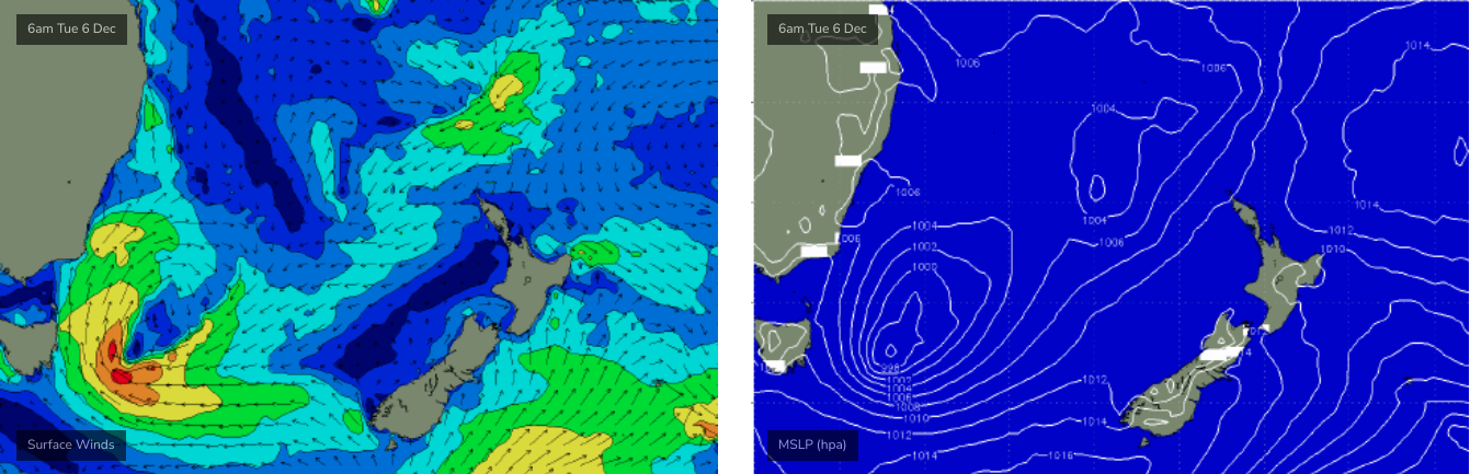
This change will be linked in with a cut-off low, sitting off the eastern Tasmanian coast, which is generating strong to gale force S/SW winds through our swell window (see above), that will build a decent southerly swell for Wednesday.
The models seem to be slightly undercalling this event, I'm expecting 3-5ft sets at south facing beaches by Wednesday afternoon (and bigger surf on the South Coast, owing to its closer proximity to the swell source). However the acute southerly direction will create a wide range in wave heights, with only small surf on offer at beaches not directly exposed to the south. So, keep a flexible mind when looking for waves as these swells are not particularly reliable from beach to beach.
Even better, local winds look great, as the low will consolidate and ease the pressure gradient across Southern NSW, resulting in light N/NW winds and generally weak afternoon sea breezes. We'll see some fun waves at south swell magnets on Wednesday.
A strong front pushing over Victoria late Wednesday will then drive SW winds out of eastern Bass Strait, building a southerly ground/windwell combo on Thursday that looks like it'll reach a wind-affected 5-6ft by the end of the day (at south facing beaches), peaking into Friday. Early Thursday morning will be significantly smaller but cleaner with a temporary window of offshore winds and easing south swell from Wednesday's pulse.
This south swell will probably peak overnight Thursday and then gradually ease through Friday with lingering S'ly winds that'll likely revert back to an early W/SW across a few locations early morning. South facing beaches should manage 5-6ft sets, down to 4-5ft by the afternoon, elsewhere it'll be much smaller thanks to the steep southerly direction.
This weekend (Dec 10 - 11)
Plenty of fun surf this weekend.
The front responsible for the Thurs/Fri south swell will evolve into a Tasman Low by the end of the week, but it'll continue to slide slowly eastwards. So, Saturday will see gradually easing S'ly swell and the trend will continue into Sunday.
South facing beaches should still be somewhere in the 4-5ft+ range (a secondary pulse from the low may nudge wave heights a little higher than late Friday), but it'll trend down to 3-4ft by late afternoon, and then to 2-3ft by Sunday.
Local conditions look very good with light morning offshores and afternoon NE sea breezes, though Sunday arvo's winds will likely kick in earlier, and become much stronger.
So, make it early for the best waves.
Next week (Dec 12 onwards)
Another approaching front/low from the west will bring about a southerly change sometime early in the week, and Sunday's late strengthening nor'easter will likely kick up a decent short range swell. So, let's see if we can pair the combo to extract a fun pocket of clean peaky waves.
Otherwise, there's nothing major standing out in the long range charts at the moment.
See you Wednesday!
Comments
Thanks for a great wrap Ben.
Hope you’re on the mend soon.
South swells fix all ailments.