More long period S swell ahead Sun
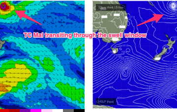
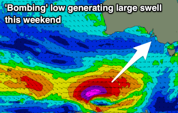
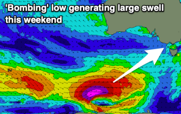
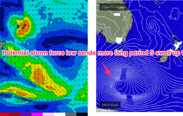
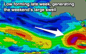
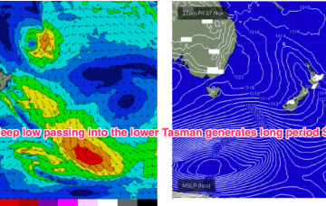
Another deep low is expected to bomb under the continent and send more long period groundswell our way late this weekend under a continuing unstable, trough pattern.
TC Mal enters the swell window later today and we may see some small E/NE swell Sat. The TC moves at angles to the swell window which is not good for swell production but there are winds to 60kts as it enters the swell window o/night so we can expect some bigger 4ft sets with rogue 5ft sets a real possibility.
Another powerful low tracking into the Far Southern Tasman- this time at potential storm force- sends more uncommonly long period S swell up the NSW Coast (although better aimed up the Tasman Sea pipe towards Fiji). With swell periods potentially in the 19-20 second band there’ll be some real juice in the swell.
Another large southerly groundswell is due over the weekend but conditions will be generally poor with nothing to surf in the gulf.
Another large groundswell is due on the weekend, generated by a 'bombing' low though winds will be mostly poor.
In the tropical South Pacific an area of convection is currently organising and deepening into a tropical depression and potential TC east of the Solomon Islands. This depression or TC is expected to race through the swell window and send a small pulse of swell our way.
The continent is unstable with a heat trough over NWWA and more troughs extending from the interior through to the East Coast. A deep low and powerful frontal system with a long trailing fetch is currently traversing the lower Tasman, generating long period S swells.
Back to back large groundswells are due over the coming week with onshore winds at the peaks.
A small lift in S/SW groundswell is due tomorrow, easing Wednesday but with strong winds.
In addition the tropical depression or TC (Mal) which is expected to track SE through the swell window Wed/Thurs is expected to send some small E/NE swell our way. It’s a tricky, compact free-standing system but we can reasonably expect some 3 occ. 4ft sets Sat into Sun with revision to come this week.