Indonesia/Maldives forecast November 9th
Thursday, 9 November 2023
Indonesia/Maldives forecast November 9th
Thursday, 9 November 2023
We've got a slight upgrade of the best swell for the period.
We've got a slight upgrade of the best swell for the period.
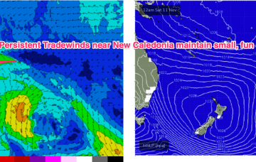
No great change to the f/cast. A large (1030hPa) high near New Zealand is continuing to direct tradewinds through the Coral Sea, with the New Caledonia region being the strongest wind area.
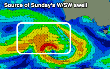
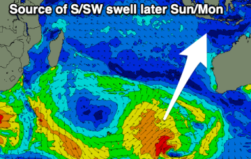
A small bump in swell today will fade into the end of the week, while next week looks active with back to back solid swells.
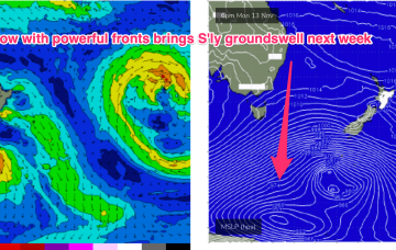
A weak ridge up the sub-tropics has a lighter E’ly flow with stronger N-NE winds south of the MNC down to the South Coast and Tasmania. We’ll see this pattern persist with increasing NE windswell across NE Tas this week. A strong frontal progression is expected to provide a series of S swells next week.
The swell producing low is looking healthy and should produce a good pulse of swell.
A weak ridge up the sub-tropics has a lighter E’ly flow with stronger N-NE winds developing south of the border. We’ll see this pattern with increasing NE windswell on the MNC and some workable trade swell in the sub-tropics.
The end of the week will offer OK waves for the keen down South, fun inside the gulf on the weekend.
The pattern established on Mon is now well entrenched with a slow moving high in the Tasman slowly being squeezed on the western flank by approaching trough systems. A weak ridge up the sub-tropics has a lighter E’ly flow with stronger N-NE winds south of the MNC down to the South Coast. We’ll see this pattern with increasing NE windswell in Central NSW and some workable trade swell in the sub-tropics. A strong frontal progression is expected to provide a series of S swells next week.
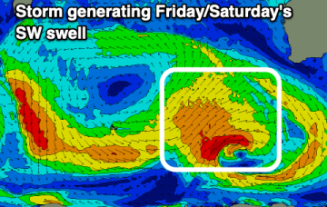
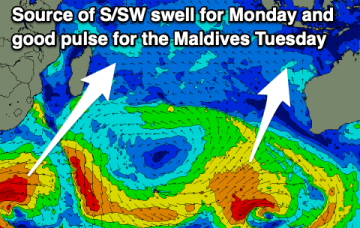
Fun pulses of swell with favourable morning winds will pad out the end of the week. Plenty of swell is due next week but with dicey winds.
Fun swell for early next week that's worth making the most of.