Fun swell for the gulf this weekend, larger from the S/SW next week

South Australian Surf Forecast by Craig Brokensha (issued Wednesday November 8th)
Best Days: South Coast for the keen tomorrow morning, South Coast Friday morning, Mid Coast late Saturday and Sunday, South Coast Tuesday and Wednesday mornings for the keen and experienced
Features of the Forecast (tl;dr)
- Building mid-period S/SW swell today, peaking tomorrow AM
- Light SE winds tomorrow ahead of freshening S/SE sea breezes
- Easing swell Fri with light N/NE winds ahead of sea breezes
- Small Sat with strengthening S-S/SE winds
- Moderate sized, inconsistent W/SW-SW swell arriving later Sat, peaking Sun AM with moderate S/SE winds, strengthening
- Easing swell Mon with E tending S/SE winds
- Moderate sized S/SW groundswell for next Tue with light-mod SE winds, freshening from the S/SE
- Larger S/SW groundswell Wed with moderate S/SE winds, freshening
- Easing surf Thu with strong S/SW winds
Recap
The South Coast saw moderate onshore winds and bumpy but workable 2ft waves yesterday morning ahead of fresher afternoon sea breezes, while this morning more variable winds are creating cleaner conditions and with a fun swell persisting in the 2ft range.
A new pulse of mid-period S/SW swell should boost wave heights to 2-3ft this afternoon but with freshening sea breezes. The Mid Coast was effectively flat yesterday, while a tiny 0.5ft hint of swell is showing today.
This week and next (Nov 9 - 17)
The small lift in inconsistent mid-period swell for this afternoon will hold tomorrow morning to a similar 2-3ft across Middleton and 0.5ft on the Mid Coast. Conditions won't be ideal with a light SE breeze, but workable before fresher S/SE sea breezes kick in,
Friday looks smaller and easing from 2ft max along with a light N/NE offshore ahead of sea breezes.
Moving into the weekend and a stronger S'ly change is due to move in on Saturday (S/SE in the gulf) as the swell reaches a low point, but later in the day but more so Sunday a good pulse of W/SW swell is due to fill in.
The source of this swell is a broad, slow moving polar low that formed around the Heard Island region on Monday, with it currently generating fetches of strong W/SW winds through our western swell window, to the south-west of Western Australia.
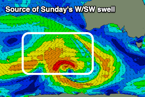
The low will weaken while moving further east over the coming days, though a stronger polar frontal progression is due to develop on its backside, generating plenty of size out of the S/SW next week (discussed in more detail below).
The W/SW energy should arrive into Saturday afternoon/evening, likely kicking to 1-2ft on the Mid Coast and peaking Sunday to 2ft.
Middleton looks to come in at 3ft later Saturday and 3-4ft Sunday morning before slowly easing. Winds will continue to favour the gulf with a S/SE morning breeze Sunday, strengthening through the day.
The W/SW energy will fade into next week, but the South Coast will see the size building more thanks to the arrival of strengthening S/SW swell pulses.
These will be generated by a strong polar frontal progression developing south-southwest of us on the weekend, and an initial low will generate a fetch of strong to near gale-force W/SW winds through our southern swell window, followed by a secondary front that will generate an elongated fetch of W/SW gales.

The first pulse of S/SW swell energy is due Tuesday, likely to 4-5ft across Middleton with Wednesday seeing a larger groundswell to 4-6ft. The Mid Coast will unfortunately miss most of this energy and be tiny to 0.5-1ft.
Winds for next week are a little average but Monday looks doable with morning E'ly winds, light to moderate SE on Tuesday morning, again doable. Moderate S/SE winds on Wednesday morning will create bumps but the strength of the swell should still provide decent surf. As the swell eases later week, poor, strong S/SW winds are likely S/SE on Friday. We'll confirm this in Friday's update though.