Windy, small week of surf

Western Australian Surf Forecast by Craig Brokensha (issued Monday November 13th)
Best Days: Tomorrow morning in the South West
Features of the Forecast (tl;dr)
- Small pulses of S/SW groundswell, building tomorrow, holding Wednesday morning, then easing
- Strong SE tending E/SE winds tomorrow ahead of S/SE sea breezes
- Strong SE tending S/SE winds Wed
- Strong E/SE tending S/SE winds Thu/Fri
- Small pulse of background SW swell Sat with strong SE tending S/SE winds
- Easing swell Sun with strong S/SE tending S winds
Recap
Friday's large increase in SW swell backed off into Saturday morning along with gusty offshore winds and sets to 6ft across the exposed reefs, though best in more protected locations. Mandurah offered great 2-3ft sets while Perth was a small but fun 2ft.
Yesterday was much smaller and back to 3-4ft in the South West, 1-2ft in Mandurah and 1-1.5ft across Perth.
Today, conditions are again clean but with tiny surf across Perth and Mandurah while the South West is blustery offshore with a small background S/SW groundswell.

Good conditions Saturday morning
This week and weekend (Nov 14 - 19)
The coming week will be mostly small but with blustery morning offshore winds and strong afternoon sea breezes. A strong high is sitting south of us and a deepening inland trough is squeezing its northern flank, bringing persistent, strong morning winds across the South West.
Tomorrow will see strong SE winds, tending E/SE ahead of strong S/SE sea breezes, strong Wednesday morning and from the SE, tending S/SE through the afternoon again.
Gusty E/SE winds are then due Thursday and Friday mornings ahead of mid-late afternoon arriving S/SE sea breezes. To the north weaker winds are due and with the absence of sea breezes from Wednesday onwards.
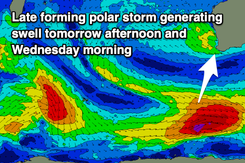
Swell wise, a small pulse of S/SW groundswell this afternoon is due to be followed up by a secondary increase through tomorrow, peaking into the afternoon and then third pulse on Wednesday morning.
The source of these swells are off axis, strengthening frontal systems skirting around the base of the high sitting south of us, and as a result, inconsistent 4ft sets are due on the South West, south magnets (not ideal with the forecast winds) tomorrow afternoon and Wednesday morning easing thereafter. Perth and Mandurah will be tiny.
Moving into the weekend and winds look to remain strong, out of the SE on Saturday morning and S/SE Sunday morning along with a small background lift in mid-period swell following a low point Friday.
Again, no major size is due, with a possible slightly better swell due early next week across the state. Winds look to remain from the south-eastern quadrant, which isn't ideal for the South West magnets as locations to the north remain tiny. More on this Wednesday and Friday.
Comments
Hey Craig, where's the Wednesday update for WA?
Sorry we've been on a work trip. Back on board tomorrow.