Residual E'ly swell to continue, as our focus shifts to the south

Sydney Hunter Illawarra Surf Forecast by Ben Matson (issued Wed 13th Apr)
Forecast Summary (tl;dr)
- Long run of east swell continuing thru' next week, though much smaller than the last few days
- Strong southerly groundswell Thurs, then another Fri (lil' smaller), and another Sun
- Generally light variable winds most days, though lingering onshores are possible north from Sydney on Thurs
Recap
Good surf was on offer on Tuesday though southerly winds were present, bumping up the open stretches. The E/NE energy managed 4-5ft sets, before easing to 3-4ft today along with a mid-period S’ly swell trailing yesterday’s change. Winds have remained out of the southern quadrant (gusty early), with only the Illawarra seeing early SW breezes. Wind strength has eased through the day though and conditions have improved.
This week (Apr 14 - 15)
E’ly swell source from TC Fili is expected to slowly ease through the rest of the week, with one final pulse from its latter stages providing occasional 2-3ft+ sets on Thursday, before size abates into Friday morning.
A more dominant southerly swell will arrive overnight tonight, sourced from a deep low south of Tasmania early in the week. Long period southerly swells always generate a wide range in wave heights from beach to beach, owing to the acute direction and the interaction between the larger wavelengths and the local bathymetry. So, expect plenty of variation across the coast.
There’s still no reason to deviate away from Monday’s call, which is for most south facing beaches to see a peak in size around 3-5ft, however we should see occasional bigger sets nudging 6ft+ at a handful of offshore bombies and reliable south swell magnets that magnify long period energy efficiently. Expect long breaks between the sets though, as is common from sources that push energy sideways up the coast.
Of course, beaches not directly open to the south will be much smaller in size, and will be reliant on the inconsistent, easing E’ly energy.
As for conditions, a lingering onshore is possible in a few locations (mainly north from Sydney) associated with a ridge across Northern NSW but most locations should see variable winds for much of the day. Note: variable means ‘from any direction’, which could be onshore.
Easing swells are then expected into Friday morning, though another flush of southerly swell is expected to push through during the morning (earlier south of Sydney) from a less favourably-aligned low and front south of Tasmania.
South facing beaches may pick up occasional 3ft+ sets (and the offshore bombies and south swell magnets may magnify this a little further) but most beaches will come in much smaller. And it’ll be very inconsistent too - but clean with light variable winds.
All in all, look to your favourite south facing beach for action over the coming days.
This weekend (Apr 16 - 17)
A developing trough in the central/northern Tasman Sea over the coming days will now sit just north of our swell window (see below), so we’re looking at small sideband energy from it over the weekend, probably some 2-3ft sets north from Sydney into the Hunter but smaller waves south from Sydney, owing to the less favourable alignment.
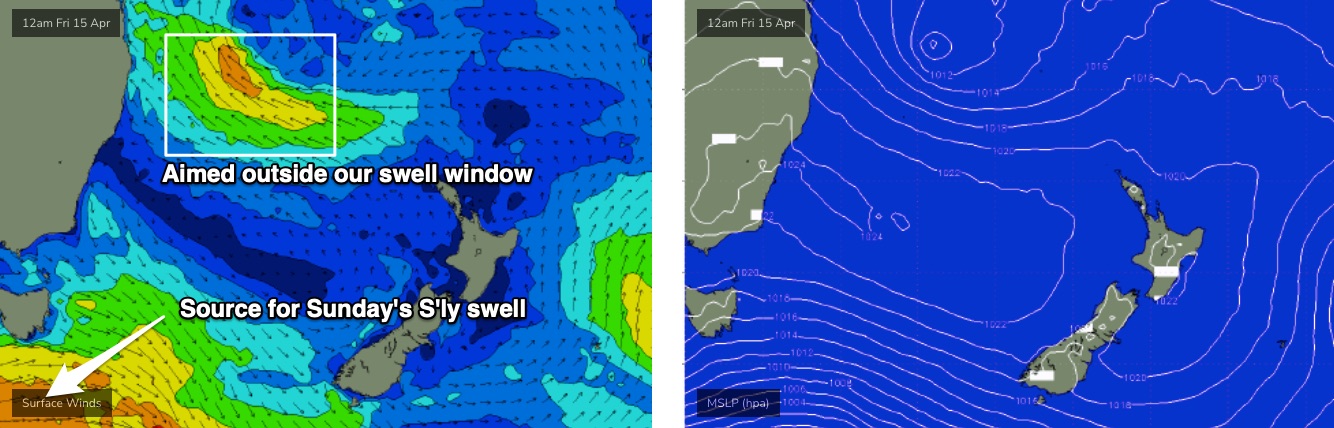
Yet another strong front pushing under Tasmania on Friday will generate long period southerly energy for Sunday, though it’ll be a brief event, up and down over the course of six or eight hours (probably focused around the middle of the day). Surf size should probably come in around 3-4ft+ at most south facing beaches, but once again bigger sets (4-6ft) can’t be ruled out at reliable south swell magnets and offshore bombies.
Early morning may come in a little udnersized at some spots, most likely north from Sydney. Light winds under a slack pressure gradient should create clean conditions.
Next week (Apr 18 onwards)
The northern Tasman trough will linger into next week and may intensify a secondary fetch off the North Island of New Zealand, so easterly swells will probably persist for much of next week - no major size is likely, with most days around the 2-3ft mark though there may be one or two periods of embedded bigger surf pushing 4ft. I’ll revise this outlook on Friday.
Otherwise, an amplifying Long Wave Trough across Tasmanian longitudes early-mid next week look like delivering strong southerly swell later next week and into the weekend.
More on this in Friday’s notes.
Comments
Great detailed forecasting as usual
Cheers Ben !
thanks mate
Hi Ben, will you be forecasting indo this year?
In what capacity? We still offer tailored forecasts through the Swellnet Traveller service. Not sure if we'll provide regular written forecasts though.
https://www.swellnet.com/traveller/details
That looks good, Thanks Ben
Easter with swell, just how it used to be. Hope everybody gets waves. Enjoy
yeww sounds epic, just need that water to keep clearing up and we’re golden!
Scored at sensational rip bowl today only 3 out .. 1.5hr is all I could manage ( covid last week ) was absolutely frothing after watching countless footage and bells .. finally got amongst it ..