Patchy for the next week or so

Sydney Hunter Illawarra Surf Forecast by Ben Matson (issued Wed 16th Feb)
Forecast Summary (tl;dr)
- Small mix of swells for the next few days
- S'ly change late Thurs and again Fri a'noon
- Average start to the weekend with onshore winds
- Small building S'ly groundswell Sat PM, showing best Sun AM with light morning winds
- Another troughy pattern early next week but with minimal swell prospects
- E and NE swell windows have potential mid-late next week
Recap
Easing leftover 3ft sets on Tuesday abated to 2ft this morning (a smidge smaller at some regions), though conditions have been generally clean with offshore winds.
This week (Feb 17-18)
The swell window’s a little quiet at the moment, so we’re not expecting much size for the rest of the week.
A small uptick in trade swell energy across Northern NSW today should filter in across Southern NSW on Thursday, but it’s only just pushing the 3ft mark up north so we’ll see only a small percentage of this filter into southern regions.
Sets should probably maintain slow 2ft sets at exposed beaches though some locations will come in under this. There’ll also be some minor NE windswell noise in the mix from today’s freshening breeze, probably no more than 1-2ft across the Sydney region (smaller in the Hunter).
However, south from Wollongong to Far Southern NSW could see some 2-3ft sets at the regional NE swell magnets thanks to the longer fetch length.
Local winds look a little tricky on Thursday as a trough slides up the coast.
In general we’ll be under some form of northerly all day, tending N/NE into the afternoon but early morning should see a window of light winds, and there’ll be a slack period ahead of the trough, which is expected into Ulladulla around 1-3pm and Wollongong around dinnertime. A fresh southerly change trailing in its wake won’t generate much windswell for our region.
Friday looks a little humdrum.
We’ll see a mix of small swells across the coast - some minor S’ly windswell from Thursday’s change, some slightly better mid-range S’ly swell from SW gales exiting eastern Bass Strait, plus a continuation of trade swell energy, similar to Thursday. So, expect size around 2ft at most open beaches (maybe the odd bigger set across the Hunter), and the morning looks clean with light winds under a trough pattern, ahead of a second southerly change that’s due to envelop the broader Southern NSW region through the afternoon (earlier down south; mid-late afternoon in Sydney).
So, get in early and keep your expectations low
This weekend (Feb 19 - 20)
Saturday morning looks ordinary, with easing S/SE winds in the wake of Friday’s change, and a mix of low quality swells, mainly from the southern quadrant. Sets might top the 3ft mark but it’ll be bumpy at those beaches picking up the most size.
Elsewhere expect a smaller mix of easing swells including trade energy from Friday.
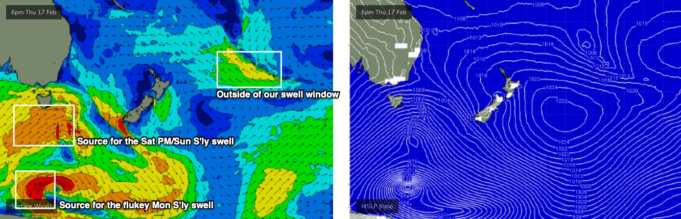
Saturday afternoon should see the arrival of some longer period S’ly groundswell, originating from the parent low to Friday’s change, as it passed below Tasmania (see below). We won’t seee a great deal of size, but south facing beaches should pick up 2-3ft sets and the Hunter should manage 3-4ft at times.
Sunday morning will be the best time to capitalise on this swell - it’ll peak overnight Saturday and into Sunday morning, and then trend down through the day, but early morning should offer early light winds ahead of a freshening NE breeze into the afternoon. So early morning should offer some nice beachies at those locations open to the south.
Next week (Feb 21 onwards)
Easing S’ly swells are expected Monday with some small peaky NE windswell thanks to strengthening winds just off shore on Sunday.
Most beaches won't see much more than a slow 2ft, however a handful of super reliable south swell magnets may see infrequent 2-3ft sets from a long range S'ly groundswell, generated by a polar low tied in with the parent low to Friday's local southerly change (see chart below). However this won't really be worth working around.
Another weak trough is expected to push up the coast through the coast through the day so expect light morning winds ahead of a southerly change.
Another small southerly groundswell - originating from the parent low to Monday's southerly change, south of Tasmania - will push up the coast on Tuesday, but it looks a little weaker than the system generating the weekend’s surf, so expect a brief flush in the 2-3ft range early morning if we’re lucky (smaller surf elsewhere).
The longer term outlook has a local easterly swell from a mid-Tasman trough mid-late week, that has some potential to become juiced up in later model runs, plus some tropical activity in the Coral Sea that could spawn a tropical cyclone in our far northern swell window later next week.
Lots to look forward to in the long term, but the short term has a fair percentage of grovelling on the cards.
See you Friday!
Comments
NZ always in the way of our swell potential lol