Solid swells to continue, though flukey winds at times

Sydney Hunter Illawarra Surf Forecast by Ben Matson (issued Mon 7th Feb)
Forecast Summary (tl;dr)
- Solid SE swells and light winds for the next few days; nothing epic but a lot better than recent offerings
- Easing swells on Thurs with early light winds tending fresh S'ly late in the day (mainly south of Syd), persisting into Fri
- Tricky weekend winds, but building swells from the SE and E/NE, possibly getting large Sun
Recap
Three days of large short/mid range SE swells with gusty SE winds. Size around the 5-6ft mark across most stretches, occasionally bigger at swell magnets. Limited options, only inside sheltered southern corners.
This week (Feb 8 - 11)
The weekend’s impressive anchored ridge encompassing the Tasman and Coral Seas is now abating in strength, however we’ve still got plenty of waves on the way.
A broad region of low pressure in the central/northeastern Tasman Sea is maintaining easterly thru’ south-easterly gales (via two seperate fetches) aimed within Southern NSW’s swell window. It’s not consolidated enough (relative to its spatial coverage) to generate truly large waves, however the fact that it’s been sitting here all weekend means we can bump up wave heights a little more than the model forecast, especially on Wednesday when the swell periods kick a touch more.
More importantly, the coastal ridge will concurrently weaken so conditions will improve. Ideally, we need an offshore breeze to iron our four days of onshore wobble, but this isn’t likely - so expect clean faces to show in the short term (from Tuesday morning) and then a gradual improvement through the lineup, holding into Wednesday morning. A moderate northerly flow is possible in a few locations on Wednesday afternoon.
Size? Tuesday morning should hold around the 4-5ft mark at exposed beaches facing south-east (smaller in protected southern ends etc) but an increase in the power settings Tuesday afternoon and early Wednesday should see some of the reliable swell magnets starting to push towards 6ft, maybe a few rogue 6-8ft sets at times. A slight drop is likely later Wednesday.
Surf size will then ease steadily into Thursday as winds become a little fruity under the influence of a local trough. Early light winds are likely but the trough will see southerly winds affecting the Far South Coast through the day, with N’ly winds to the north of Sydney, and a slack region between where anything is possible. Early sets should be around 3-4ft at open beaches but we’ll be down to 2-3ft by the end of the day.
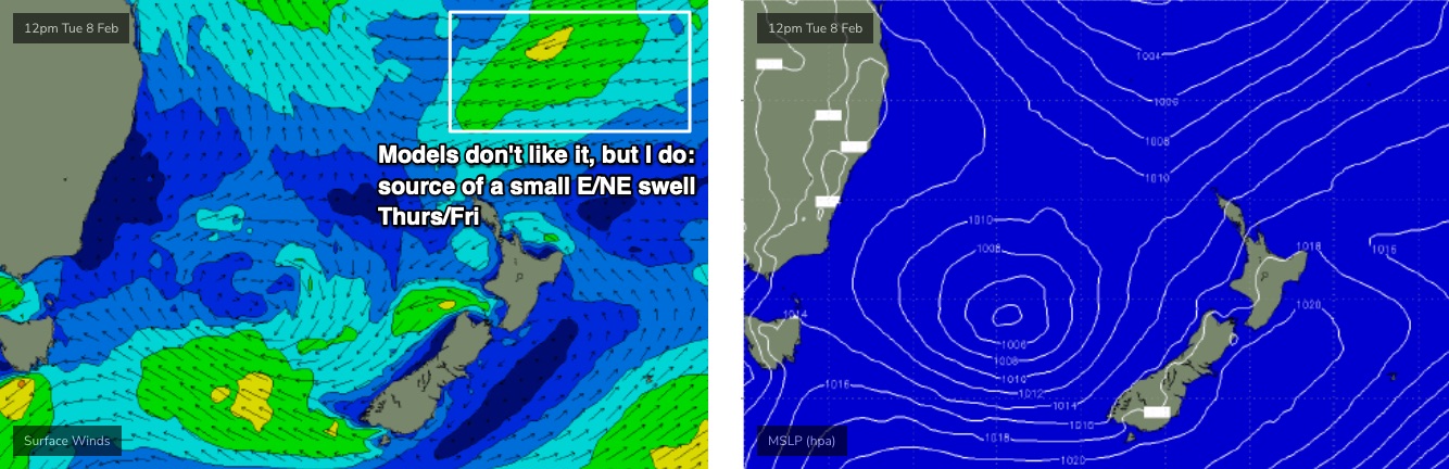
There’ll be some E/NE swell in the mix by this time too, from a pre-monsoonal fetch developing north of New Zealand at the moment.
Thursday’s approaching S’ly change should nose into the Illawarra late afternoon, pushing into Sydney overnight - though model guidance has a slow, meandering pace which lowers the confidence for Friday’s winds (hell, Thursday’s aren’t a sure bet either). Small residual swells mainly out of the E/NE should maintain inconsistent 2-3ft sets at exposed beaches. The models aren’t liking the E/NE source very well (see below) but I reckon it’ll produce sporadic waves at the swell magnets, however we’ll be working around the local winds to score anything worthwhile.
This weekend (Feb 12 - 13)
A tropical cyclone is expected to develop between New Caledonia and Vanuatu over the coming days. This will be positioned inside the NSW swell shadow, however a related E/NE fetch (mentioned above) will supply small swells for our region Thurs/Fri. I’m expecting this source to gradually ease into the weekend though.
The outlook for the weekend hinges on where the cyclone moves to, and how fast. At this stage it’s expected to display an impressive N/NE fetch on its eastern flank, which is is slightly out of alignment for our swell window - but we’ll still see a spread of energy back towards the Australian East Coast. The cylcone will then track towards New Zealand at a moderate pace.
A broadening ridge through the western Tasman Sea - abutting the cyclone - will also be poorly aimed within our swell window, but will still generate some useful sideband energy for most regions (mainly northern).
So, the specifics are a little hazy right now but I’m ball parking a mix building swells on Saturday from 2-3ft to 3-4ft, ahead of a more prominent increase in E/NE tending E’ly groundswell (from the cyclone) on Sunday that could push up into the 5-6ft range.
Winds look tricky on Saturday with easing southerlies in the lee of the trough, but we’ll take a closer look over the coming days.
Next week (Feb 14 onwards)
All eyes will be on this cyclone. Most of the models suggest it’ll undergo extra-tropical transition pretty quickly, and slide into the NZ swell shadow, with its forward speed expected to be a little too fast to generate a truly memorable swell event. However, we can’t rule out a more favourable path at this stage.
See you Wednesday!
Comments
Well the last swell was unsurfable hopefully it cleans up enough so
we can at least catch a wave.
How bad have the winds been.. cracking swell unsurfable though.. one positive is the rip bowls every where along the local .. the banks will be insane once the winds piss off ..
Finally got in the water early this morning. Nice clean conditions with the odd 4-5ft wedges. Wore my 3/2 and so warm that I felt sick.. so hard to pick if the water is going to hot or cold with the mix of swells around lately.
Noticeable jump in intensity mid-arvo, local started breaking on different parts of the reef. Shame the wind wasn't as good as this morning.
How big?
6ft+ when the sets came.... some solid water moving around, cleaned the lineup out a few times. It was pulsing a few sets at a time then big lulls.
Few double overhead clean up sets from about 6pm. Real kick.
Noticeably backed off this morn. Banks ordinary and pretty much just close outs. Our dawn reporter still keeps saying it's pumping though.
Slightly different story fifty clicks south of you, Fraz.
With these conditions Stu it would have to be pumping all over the place - just a bit big and straight for our banks atm. Still getting strong sets here, just not those monsters of yesterday arvo.
Solid first thing this morning at my local beach in the Illawarra area, easy 6ft on the sets with a lot of water moving. Swell seems to have a fair bit of east in it, with the more southern end of the beach still big. Definitely already dropping though by the time I got out (about 7 30)