Only one small swell to work around

Sydney Hunter Illawarra Surf Forecast by Ben Matson (issued Wednesday 28th July)
Forecast Summary (tl;dr)
- Small flush of S'ly swell Thurs PM (South Coast), showing best across most regions Fri AM
- Clean conditions with generally offshore winds; keep an eye for N'lies Fri PM
- Tiny weekend of waves, just small peripheral sources
- Small S'ly swell Wed
- Better S'ly swell potential Thurs/Fri
Recap
Small leftover S’ly swell in the 1-2ft range on Tuesday faded in size this morning, otherwise we’ve seen a minor NE windswell to 1-1.5ft. Light offshore winds Tuesday freshened from the NNW today.
This week (July 29 - 30)
A vigorous front will push east of Bass Strait tonight, and strong to gale force W/SW winds in its wake will generate a flukey south swell for Southern NSW.
The leading edge of this swell should reach the South Coast after lunch Thursday (so, expect tiny leftovers early), but it may arrive too late across Sydney and Hunter coasts - i.e. mid-late afternoon - to justify a late paddle. Though, it can’t be ruled out so keep an eye on your favourite south swell magnet.
Wave heights should reach a brief peak in the early hours of Friday morning, and will trend down throughout the day, so expect the biggest surf around dawn. Most south facing beaches should pick up 2-3ft sets and the Hunter should see bigger waves in the 3-4ft range.
However, beaches not open to the south - and there’s quite a few of ‘em - will be much smaller. Expect smaller surf into Friday afternoon.
Conditions should be clean both days with moderate offshore winds Thursday morning easing into the afternoon and holding early Friday. Afternoon northerlies are likely on Friday.
This weekend (Aug 1 - 2)
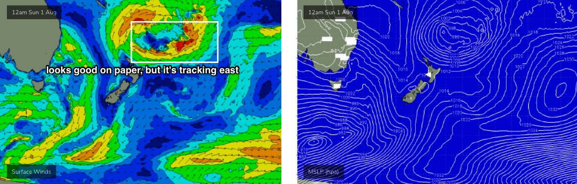
Chances for a small flukey SE swell this weekend have vanished, thanks to the models pushing the stalled Tasman Low (in the wake of the current front) a little further east, essentially too far north and east of our swell window. It was only a fleeting opportunity at best in Monday's notes anyway.
As such, surf conditions will remain small all weekend, with very little leftover S’ly swell expected on Saturday. Both days should see minor energy from the E/NE originating from a stationary tropical depression near Tahiti last weekend, but I’ll be surprised if set waves nudge higher than 1.5ft every ten or fifteen minutes. This will however be ideal for beginners.
At least conditions will be clean with light to moderate offshore winds both days.
Next week (Aug 3 onwards)
The first half of next week is looking similarly small.
The storm track is still aligned away from our Southern Ocean swell window, and although we’ll see an impressive E/NE fetch develop around the southern flank of the Tasman Low near New Zealand from Friday or Saturday onwards (see below), it’ll be tracking unfavourably eastwards at the same time which greatly diminishes its swell potential.
So, ignore the single-snapshot synoptics, as it’s a misleading swell source.
A small progression of cold fronts are expected to push out from Bass Strait on Monday and Tuesday and this may kick up a small south swell for Wednesday but right now I don’t think we’ll see anything amazing in the surf department.
A stronger front of polar origins will round the Tasmanian corner around Wednesday, setting up much better potential for a strong south swell later next week (Thurs/Fri), but this is still quite some time away. However this remains the most optimistic timeframe for a return to more typical winter swell pattern.
More on that in Friday’s update.