Long run of tropical activity coming up

Sydney, Hunter and Illawarra Surf Forecast by Ben Matson (issued Monday 25th January)
Features of the Forecast (tl;dr)
- Plenty of swell all week but generally wind affected
- S'ly change due overnight Tues
- SE winds Tues tending E'ly Fri, then NE Sat
- Extended period of solid E/NE swell next week, possibly sizeable at times
Recap: The weekend picked up some fun waves, though winds freshened from the N/NE throughout the days, following periods of light winds early mornings. Friday’s S/SE groundswell eased from 3ft+ to 2-3ft during Saturday, and we saw a small building NE windswell through the day that built further into Sunday, offering 2-3ft sets at exposed beaches, holding into this morning. A new S’ly groundswell also built on Sunday and has persisted today, with sets around the 3ft mark at most south facing beaches, even a few bigger 3-4ft sets reported at some south swell magnets. Interestingly - and perhaps reminiscent of last week’s flukey S’ly groundswell across the NSW coast - the Hunter region has picked up much smaller surf from this most recent south swell, which is unusual as it normally outperforms just about everywhere, sometimes by an order of magnitude.
This week (Jan 26 - 29)
Our current southerly swell will ease slowly through Tuesday, though early morning should see some lingering sets across south swell magnets. I’m not entirely sure why the Hunter is missing out on the current southerly swell, so I’m reluctant to both commit to a size and/or downgrade in a reactionary manner (because, 95% of south swells are bigger here than most other coasts).
So, let’s allow for early 2-3ft sets at south facing beaches very early Tuesday, with perhaps 3-4ft bombs at the Hunter, but expect long breaks between waves and an easing trend for the day. Just for good measure, keep your expectations low across the Hunter.
Local NE windswell will become the dominant energy on Tuesday morning anyway, easing from 3-4ft, though with gusty winds creating bumpy conditions at times. However there is a suggestion that the coastal ridge may push just out to sea through the morning, creating lighter winds (read: moderate strength) with a little more North, maybe N/NW in direction for a period - so the best chance for workable options (if at all) will be through the morning. It’s not worth getting too excited about though.
A trough will push along the Far South Coast in the afternoon, bring a southerly change to these parts around dinnertime, arriving in Sydney overnight. This will provide gusty S’ly winds for Wednesday plus a building S’ly windswell to 3-4ft by the afternoon, in addition to easing NE windswell from 3-4ft at dawn to 2-3ft by mid-late morning, becoming smaller into the afternoon.
Wednesday’s best waves will therefore be at protected southern ends.
A strong ridge filling in behind Wednesday’s change will slowly veer winds from the SE to the E/SE on Thursday and Friday, holding moderate to fresh strength north from Sydney, with gradually lighter strengths to the south - though still generally onshore. This will keep surface conditions below average fort the rest of the week. I’m not very confident for periods of light variable winds through the mornings as we often see, because the synoptic flow looks a little too robust. But, it is a possibility south from the Illawarra, mainly on Friday.
Of course, these onshore winds will also generate local swells for the coast, so the rest of the week shouldn’t drop below 3-4ft and there’ll be plenty of wobbly waves on offer. There’ll also be some small south swell in the mix from a cut-off low passing below Tasmania on Tuesday night.
Also in the water through the rest of the week will be a building secondary trade swell from a ridge in the Northern Tasman Sea, stretching out into the South Pacific. The energy from this source will be smaller than that of local origins, but it’ll contribute peaky waves to the open beaches.
This weekend (Jan 30 - 31)
Later this week, the majority of the Tasman Sea will be under the influence of some form of ridge, and thus some form of easterly flow, holding through the weekend. This means we’ll see plenty of easterly swell all weekend, though of no major quality as it’ll be a mixture of overlapping mid-range swell trains.
Winds are expected to swing to the NE on Saturday and freshen as a trough approaches from the south. The trough should bring about a period of lighter winds sometime late Saturday or (more likely) early Sunday, ahead of a possible S’ly change that afternoon, but it’s too early to have any confidence. The South Coast is more likely to benefit than anywhere else.
As for size, wave heights should fluctuate in and around the 3ft mark both days, if anything a little higher on Saturday. There'll be bumpy options all weekend, though it looks like prime bluebottle conditions too!
Next week (Feb 1 onwards)
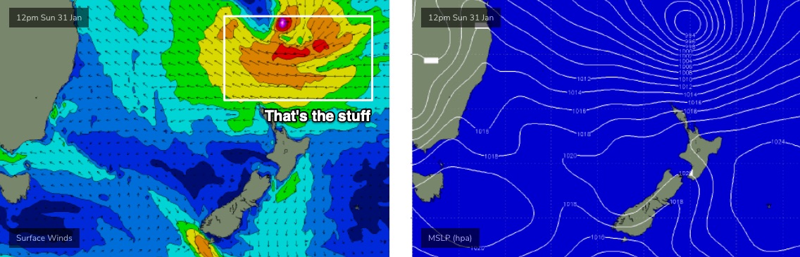
Our broadscale south swell window is about to become a little quiet as the tropics fire up under the passage of an MJO phase. This is expected supercharge the trade flow across the Northern Tasman Sea and South Pacific from this weekend onwards (see below), and there’s a distinct possibility that one or two Tropical Cyclones may drop south from the Fijian region, adding even more energy into the mix.
It’s too early to plan specifics, but right now we’re looking at a whole week of solid E/NE swell, in particular becoming sizeable (i.e. 4-6ft) sometime around Tuesday, peaking Wednesday, potentially a little higher, and maintaining strong energy through the rest of the week.
Let’s see how Wednesday’s model runs are looking. But.. get ready for a decent run of tropical-sourced swell.
Comments
Nice 4-6ft sets ground swell in the Illawarra south swell magnets this afternoon. Just a little slow at times.
Fun NE wind swell and westerly winds late morning
Classic morning of waves around the northern Illawarra yesterday.
Early session was marred by NE winds that had blown all night but at 9am on the dot the wind swung NW, almost instantly ironing out the wrinkles and folds revealing clean 2-3ft waves sparkling in the sun.
Many good waves ridden at the local with rumours about the beach a few kms south on the boil.
Few hours into the wind change I could see the NEer out to sea - a line of dark blue signalling the demarcation - but its approach was stalled by a wrestle with the NWer. Get yer last waves now. Took a while but the seabreeze finally prevailed bringing the curtain down on a classic li'l summer morning.
I saw that too it’s amazing you can be 200 metres from the beach it’s hot as hell there . Yet right on the beach it’s a cool neaster blowing strong
Killer day yesterday, too hot, and the central coast local has never been so crowded, at least in terms of cars. I just waited it out. Middle of the day like laying on a frying pan, even undercover and open to any wind. Nor Easter eventually kicked in. Phew.
I’ll get mine next week.
Next week looking pretty exciting for east coast and I might just be in a prime position to take advantage of it.