A week of mediocrity to get through

Sydney, Hunter and Illawarra Surf Forecast by Ben Matson (issued Monday 19th October)
Best Days: No great days overall, but there'll be small rideable options all week if you're keen.
Recap: A small mix of east and south swells dominated the weekend, holding 2-3ft sets at most open beaches through Saturday, if anything showing best on Sunday with occasional bigger sets through the Hunter. A small NE windswell also built Saturday afternoon as local winds freshened from the same direction. Sunday morning offered the best conditions with early light winds ahead of afternoon sea breezes and then a late southerly change. Easing southerly winds today have accompanied a small renewal of south swell and some minor leftover east swell. Overall, it’s been pretty ordinary.
This week (Oct 20 - 23)
Unfortunately, a quiet synoptic chart across the Tasman Sea this week means we’re looking at a continuation of small swells. Fortunately, the long term outlook has a lot more potential, but for now it’s looking like a handful of grovelly days ahead.
Following a period of light winds throughout Tuesday, we’re looking at an extended period of N/NE winds from Wednesday thru’ Saturday. Initially they won’t be too strong, but they will adversely affect surface conditions at exposed spots, particularly later Thursday and Friday.
As for surf, we’ve got a couple of peripheral sources.
A small mid-Tasman ridge building in the wake of last night’s change will generate small easterly swells for our region later Tuesday and Wednesday.
The parent front/low to the southerly change was poorly aligned (well below Tasmania) but will generate small southerly swells around the same time. I’m doubtful of much more than a stray 2-3ft set at south swell magnets.
The most interesting - but also, the most flukiest - swell source is a series of overlapping long period southerly groundswells, generate way out in our far, acute south swell window over the last week (the origins of this storm progression was south of South Africa and Madagascar over a week ago). These swells have very long swell periods as forerunners (20 second detected in WA this morning) but initially we won’t see much energy glance the coast due to the poor alignment and enormous travel distance.
The first swell will push through the lower Tasman Sea sometime on Wednesday, before easing Thursday. The second swell will then push through on Friday, before easing slowly Saturday.
Most locations won’t see anything from these sources, in fact even those locations lucky enough to pull in stray sets will require an extraordinary amount of patience as it’ll be twenty minutes or more between waves. It’s not worth working around at all, but nevertheless, these swells are worth keeping an eye out for in the event the provide occasional waves to regional swell magnets (i.e. the Hunter is normally your best bet).
Friday’s strengthening N/NE winds will generate some small local windswell for the end of the week but Saturday is a safer bet for the most size.
So keep your expectations low all week - there’s really nothing to get excited about.
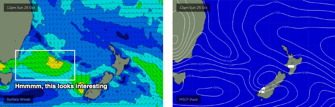
This weekend (Oct 24 - 25)
Peaky NE windswells on Saturday should reach 2-3ft+ at open beaches but conditions will be pretty average thanks to an accompanying N’ly breeze.
An approaching trough from the west will push into the lower Tasman Sea on Saturday, driving strong southerly winds along the Southern NSW coast overnight Saturday and generating punchy local windswells for Sunday, into the 3-4ft+ range by the afternoon. However with the NE windswell rapidly easing by this time there won’t be many options at sheltered southern ends.
Keep your expectations low, again.
Next week (Oct 26 onwards)
The weekend’s trough certainly has the potential to be upgraded over the coming days, lingering in the Southern Tasman Sea as a decent source of SE swell for our region early next week (see below). However, if it is upgraded, so too could be the strength of the local wind. So, I’m being cautiously optimistic about this pattern.
Of more interest is a ridge just NE of New Zealand modeled for this weekend, and a broad region of low pressure in the tropical South Pacific. A developing easterly squeeze between the two should set up an extended period of E/NE swell for the East Coast, and small embedded low pressure troughs are a potential source of enhanced swell generating activity that I’ll be keeping a very close eye on over the coming days.
The resulting swells are still well over a week away (middle to latter part of next week onwards) but I do like the look of the long range charts right now.
Let’s take a closer look on Wednesday.
Comments
Interesting Ben. Interested to know how a 20sec period swell result in 20 min intervals between sets.
Just to clarify - the time between sets isn't necessarily related to the swell period. I specifically referenced "twenty minutes or more between waves" to highlight just how inconsistent it was going to be (because saying "it'll be very inconsistent" doesn't particularly stand out).
More interesting - how does a swell generated south of South Africa get around the corner to even give us an occasional wave?
You've misinterpreted what I wrote. To quote:
"...the origins of this storm progression was south of South Africa and Madagascar over a week ago."
Any swell that flukily reaches the NSW coast will have been generated below Australia.
Ahhh, that makes more sense.
teaqueue was not alone...tbb just checked Madagascar Cyclone Watch ('Missed one?)
Ben invented a swellbubble that rolls overhead with the clouds, then dumps the swell.
Here's how the swellbubble rolls...
https://www.facebook.com/abccentralcoast/videos/vb.161191673896350/65283...
https://www.facebook.com/Mac.Snaps.Photography.Australia/photos/p.327134...
https://www.facebook.com/photo.php?fbid=10158957052342376&set=p.10158957...
https://www.facebook.com/DUSTYIMAGES1/photos/p.784037935720407/784037935...
https://www.facebook.com/abccentralcoast/photos/a.943650442317132/404816...
https://www.facebook.com/photo.php?fbid=10164325670080524&set=p.10164325...
Check ABC Central Coast Site for same storm > (Neat mini Cyclone Gif!)
https://www.facebook.com/pg/abccentralcoast/posts/
Looking forward to tonight's notes.