Peaky blend of swells for a few days, ahead of a complex cyclone swell

Sydney, Hunter and Illawarra Surf Forecast by Ben Matson (issued Friday 15th February)
Best Days: Fun weekend of waves (cleanest in the mornings), persisting into Monday though with freshening NE winds. Keep an eye out for an unusual NE groundswell late Tues/Wed, possibly large Thurs. And then a large SE groundswell is on the cards for next weekend through the early part of the following week.
Recap: We’ve had some fun waves over the last few days, with a lovely 3ft+ blend of S’ly and E’ly swells coinciding with generally light winds and sea breezes to produce fun waves across open beaches.
This weekend (Feb 16 - 17)
Today’s Forecaster Notes are brought to you by Rip Curl
We’ll see some fun surf this weekend, though you’ll need to surf early for the best waves.
A series of poorly aligned fronts below Tasmania will generate small southerly swell for exposed beaches over the weekend. No major size is expected at most spots, but reliable swell magnets (such as the Hunter) should pick up occasional 2-3ft waves. Size will ease into Sunday.
Otherwise, we’ll see a continuation of pulsey E/NE swell from the existing ridge through the Tasman Sea, and the confluence of tropical and subtropical weather systems developing across its northern extremities.
On Wednesday I pegged size holding an inconsistent 2-3ft on Saturday, building a little more into Sunday with occasional 3-4ft sets, and I think this call is quite reasonable. Expect long breaks between the bigger waves though.
Winds will remain light both mornings but we’ll see freshening NE breezes after lunch both days, with Sunday expected to see more strength than Saturday. So aim for an early session for the best conditions.
Next week (Feb 18 onwards)
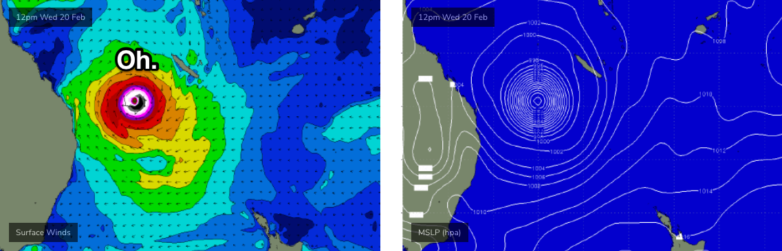
In Wednesday’s notes I discussed the broad gyre-scale atmospheric circulation across the New Caledonia, Vanuatu and Fijian regions, containing TC Oma (Cat 2).
Successive model runs have since developed the forecast path for TC Oma in quite an incredible fashion, and we’re potentially looking at several phases of large swells for Southern NSW as a result (with very large waves for Northern NSW and SE Qld)
However, this is not likely to occur until later in the week.
Prior to then, Monday and Tuesday will see a peaky mix of S’ly swells (from a polar low and frontal system south of New Zealand today), E/NE trade swell (from the supporting ridge south of TC Oma, across the Northern Tasman Sea) and some local NE windswell. As a reference point, the E/NE swell should ebb and flow around the 3ft mark for most of the week, with less size from the other sources earlier in the week.
Monday looks a little tricky on the surface with freshening NE winds as a shallow trough moves up the coast, that may provide southerly winds to some regions on Tuesday (more likely south from Sydney, than north).
From very late Tuesday into Wednesday, we'll see some initial long period groundswell from TC Oma glance the coast.
Just to rewind a little: late Sunday and into Monday, TC Oma is expected to push around the New Caledonian swell shadow, and will likely be displaying core wind speeds of 50-70kts+ as it tracks S/SW towards Northern NSW.
There’s an extremely narrow though plausible swell window through to Southern NSW from this region, however the flukey, long range nature of this swell source, the initial short fetch length and the many geographical obstacles means that only a handful of locations will likely pick up any size. And, they’ll all be reliant on favourable bathymetry to rake in the energy.
And if I’m completely truthful, I don’t know where most of those locations might be. The reason is simple: we haven’t seen a long period NE cyclone swell like this for an extremely long time, so I’m not sure how each coast will react. Of course, we can default to the polar opposite of our favourite geo-referenced swell magnet, the “south facing beach”. But, it’s not as easy as that - beaches facing north won’t automatically see a significant size loading just because of their coastal orientation. It’s all got to do with the offshore bathymetry.
So, you’re gonna gave to get out there and have a look around.
Don’t be shy in your highway mileage either; wave model guidance has Wednesday afternoon around 1m @ 16 seconds (Northern Beaches), which should theoretically translate to 5-6ft surf at reliable north facing swell magnets - none of which I am confidently aware of - so if you rock at up one stop and it’s only small, look around the corner, and then the next, and so on, because if this system develops as forecast, somewhere should be pulling in this swell and offering something halfway decent.
(BTW, the 5-6ft reference above is not a forecast. I’ll be stoked if we have a few punters report 3-4ft surf from this swell, though it also means I won’t be terribly surprised if we hear reports of 6ft barrels either).
Wednesday looks good on the surface with light variable winds; a fresh S’ly change is due Thursday.
From here on, the forecast gets way more tricky. We’re likely to see TC Oma undergo extra-tropical transition (becoming a cold core system, from a warm core system) as it tracks SE towards New Zealand, interacting with a high pressure ridge to the south and broadening a long, powerful SE fetch through the Tasman Sea.
Whatever flukey NE swell we see on Wednesday will may become even bigger and more broad in coverage into Thursday, as TC Oma tracks further into the Tasman Sea, and the fetch becomes more E/NE. it's still early days but based on the available model guidance, we're potentially looking at some large NE swell well north of 6ft, maybe even 6-8ft (model data suggests more right now, but I want to be cautious on this).
However, the same caveas apply for Thursday as they do for Wednesday; mainly because this is quite some time away and small revisions in the size, strength and forward speed of the cyclone could (and probably will) change these figures - and that could be both up or down. Hopefully local S'ly winds winds won't be as strong as expected either.
Thursday’s windy conditions will likely persist into Friday, but the new SE groundswell from this merging of weather systems near New Zealand is likely to produce very large SE swells across the NSW coast - biggest in the north, but still quite sizeable in the south.
It’s still very early days, and given the significant variations in model output over the coming days, I do want to be a little cautious in next weekend’s size estimates: but at this stage I’ll peg wave heights around the 6-8ft range. No point sitting on the fence, eh?
Have a great weekend, see you Monday.
Comments
sounds great! i feel like this big easterly swell has been about a week away for about a month! very inspiring forecast though. cheers mate!
Overly long and technical analysis. All I recall is that Ben is guaranteeing 6 foot barrels on Wednesday afternoon. Locked in.
...and any beach facing north is gonna pump. Booking Wed arvo off now
Is global warming good for swell production?
Winds are looking a bit dodgy from the 19th. Is there much chance that this will change?
I hope this swell is big and washy so the banks are shapely primed for Autumn.
yep... agree with this
Hows that onion ringed MONSTER!!!??? Looks so sexy. I hope it produces well.
Some serious sand movements won't go astray either for a lot of beaches I frequent, as with NW above hoping to put some sand out for autumn.
Another Sunday, can't park within a km of the 'bra, clubbies, nippers, circuses, the latte set. Not so many in the water, if you can get there, and find a piece of water not taken up by clubbies, nippers, circuses!!!
I'd be happy for just a nice body bash.
I have been bodybashing exclusively for the past month. I'll appreciate waxing up the 6'8 next week though
bit of a late start today, monday and all...by the time i got down there bronte was an absolute washing machine.