Stacks of swell for Southern NSW, but looking best mid-late next week

Sydney, Hunter and Illawarra Surf Forecast by Ben Matson (issued Friday 31st March)
Best Days: Sat AM should see early offshore winds with average leftovers from today. We'll see plenty of swell from Sat PM thru' Tues but onshore winds will create a few problems. Late Wed and (more likely) Thurs and Fri look great with light winds and a strong E/SE swell.
Recap: Thursday morning offered a window of clean conditions and a peaky NE swell in the 2ft+ range. Strong S’ly winds kicked in after lunch and this has built a S’ly windswell that’s managed 4-6ft sets at south facing beaches today. Though quality has been pretty average under a gusty S/SW breeze.
This weekend (Apr 1 - 2)
Note: Forecaster Notes will be brief this week because Craig’s on leave.
Today’s southerly airstream will ease overnight and should trend light W/SW early Saturday morning. However, an approaching change will swing the wind to the SW and freshen through the morning. I’m expecting winds to go fresh S'ly at some stage later Saturday, but the afternoon’s speeds shouldn’t be too strong; they may veer more S’ly but conditions should be (just) workable.
Wave heights will trend down from today into Saturday, with early 3-4ft sets at south facing beaches down to 2-3ft by lunchtime. Expect smaller surf at rermaining beaches and a possible small drop into the afternoon.
Saturday’s late change will kick up a fresh S’ly swell for Sunday though winds will remain from the south so quality won’t be great. Expect a building trend to a bumpy 3-5ft at south facing beaches with smaller surf elsewhere due to the swell direction. There’s a slim chance for a brief SW breeze at a handful of locations around dawn (i.e. Northern Beaches) but I wouldn’t bank on anything special.
Also in the mix late on Sunday afternoon will be some small long period groundswell from an intense Southern Ocean low that’s expected to deliver very large waves to Victoria this weekend. However this swell will be much smaller than that of the short range energy associated with Saturday’s change.
Next week (Apr 3 onwards)
The second half of next week looks unreal.
But we'll need to get through a few days of dicey winds before then. The weekend’s southerly change will merge with the lingering remnants of ex-TC Debbie off the North Coast on Monday, forming a new trough that will extend SE back into the eastern Tasman Sea.
This fetch will initially be aimed towards the Qld coast but its southern extension (and broad coverage) means we’ll see a decent spread of E’ly swell across Southern NSW from later Monday onwards. For what it’s worth, Monday morning will see a temporary dip in size from Sunday, as we'll be between swells - though there will be inconsistent long period S’ly groundswell up to 3ft+ at a handful of reliable south swell magnets. Expect smaler surf everywhere else.
This system in the Tasman Sea will then remain the dominant swell source through the middle to latter part of the week. The models are suggesting we’ll see the tail end of the fetch deepen into an intense Tasman Low around Wednesday through the strongest winds would be along its western flank, aimed up towards the Coral Sea - so we'll see a smaller spread of swell across Southern NSW. There will however be a broad SE fetch on the low’s southern flank, extending down to the SW tip of the South Island, aimed nicely in Southern NSW’s swell window.
A secondary E'ly fetch is also expected to develop out of Cook Strait - the body of water seperating New Zealand's North and South Islands - from later Monday, and this should provide some longer period E'ly energy into the mix around Wednesday and Thursday. If this fetch is upgraded over the coming days, we'll see surf size increase a little through the second half of the week.
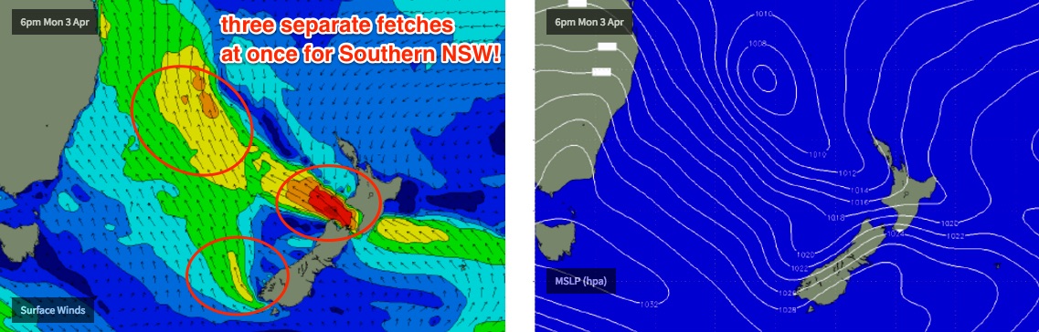
Anyway, this slow moving pattern should ensure a long lived E/SE swell event for much of next week, fluctuating in the 4-5ft+ range at exposed beaches from Tuesday through until Friday morning. Size will then ease into the weekend.
Lingering onshore (SE) winds look like they’ll be a problem on Monday, Tuesday and potentially early Wednesday, but as the Tasman Low forms mid-week it’ll ease the pressure gradient across the coastal margin resulting in light variable winds to finish the week. So, if anything aim to surf from Wednesday afternoon onwards (Thursday is the pick of the forecast period at this stage, also Friday morning).
Have a great weekend, see you Monday!