Peaky mix of swells to finish the week; Saturday the pick of the forecast period

Sydney, Hunter and Illawarra Surf Forecast by Ben Matson (issued Wednesday 15th February)
Best Days: Thurs: small building S'ly swell before the NE breeze kicks in. Fri: plenty of NE swell though local winds will probably ruin conditions. Sat: excellent peaky NE swell (easing, though) with light winds. Tues/Wed: chance for a SE groundswell.
Recap: Plenty of strong S’ly swell on Tuesday in the 4-5ft range, though fresh onshore winds kicked in throughout the morning, deteriorating conditions across most beaches. Wave heights eased further into this morning with 3ft+ sets at south facing beaches and conditions were much cleaner with light offshore winds. Even this afternoon’s sea breeze have been very light so conditions have been smooth.

Fun Bondi this afternoon, though a little closey
This week (Feb 16th - 17th)
Freshening NE winds over the coming days will dictate wave quality.
Initially, light NW winds on Thursday morning should create clean conditions however wave heights are expected to back off further from today.
A new pulse of S’ly swell originating from a polar fetch (related to the same system responsible for the Mon/Tues swell) will push up during the day though wave heights may be a little undersized early. As it is, our model isn’t picking this swell up very well and I’m not especially confident in the likely size range, however we should see occasional 2ft+ sets at south facing beaches by the afternoon. Expect a chance for smaller surf early morning, and even when it does kick in there’ll be long breaks between the sets.
The afternoon’s best conditions will be confined to protected northern corners as the nor'east breeze kicks up.
The models have strengthened and sped up a developing NE breeze throughout the second half of the week, which has brought forward the likely increase in short range NE windswell on Friday. We’re now looking at 2-3ft sets for much of the day with a few bigger bombs late afternoon (possibly 3-4ft at reliable swell magnets), though south facing beaches will be smaller with a mix of residual S’ly and refracted NE swell.
Winds will be quite gusty from the NE during the day though so expect conditions to be quite average at open stretches.
This weekend (Feb 18th - 19th)
A weak trough will develop across the South Coast during Friday night, extending a brief, shallow S’ly change across the coast.
However it won’t last long and Saturday looks to deliver mainly light variable winds for the most part, and thus clean surface conditions.
The source of Friday's NE windswell will retreat back into the swell window as a result of this trough, but we should still see an early peak in size before wave heights trend downwards throughout the day. Early 3ft+ sets at NE facing beaches are quite likely but it’ll probably ease to around 2ft by the end of the day. So aim for the early surf for the most size.
Sunday looks a little dicey right now. The trough is expected to form into a small closed low off the coast and will drive gusty S/SE winds into most regions. This should generate a small local windswell though no great quality is expected, probably bumpy 3ft sets at south facing beaches with some small residual NE swell at remaining beaches.
But for now, aim for Saturday as it’ll offer the pick of the weekend’s waves.
Next week (Feb 20th onwards)
Two regions of potential quality surf were identified in Monday’s notes for next week.
However, the models have become quite divergent regarding the strength of both developing weather systems since Monday. The US model has weakened the Tasman system but the European model intensifies Sunday’s trough into a deep Tasman Low on Monday, sliding it SE from Tasmania. This suggests a good quality (and possibly sizeable) SE groundswell through the first half of the week though likely wind affected on Monday. The US solution is for a smaller S/SE groundswell a little later (Wednesday) from a smaller low positioned a little further away.
However with the models swinging around quite a bit we really need a few more days to bed things down.
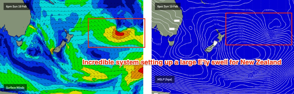
As for our tropical swell window, we’re still looking at a very large high pressure system east of New Zealand interacting with a broad area of tropical activity near the Fijian region. However it now looks like the convergent point between the two systems will occur further east and south than Monday’s model guidance placed it, which is inside the New Zealand swell shadow (for Southern NSW).
This is a real shame as the models have actually strengthened the fetch and also instigated a westward flow towards the end of the run that would likely supercharge the pre-existing swell. As such, the East Coast of New Zealand’s North Island is in for one heck of an excellent groundswell during the middle to latter part of next week, and the following weekend. We should also see this swell reaching Far Northern NSW and SE Qld though the large travel distance will erode some size.
Anyway, all of this is still quite some time away so let’s see how Friday’s model runs are looking.