Easing E'ly swells with pockets of good winds

Sydney, Hunter and Illawarra Surf Forecast by Ben Matson (issued Wednesday 8th February)
Best Days: Thurs: easing E'ly swell with early light winds. Fri: smaller combo of E/NE swells and a chance for a period of light winds. Sat/Sun: small swells and mainly light winds. Mon/Tues/Wed: Building S'ly swell but tricky winds.
Recap: Tuesday remained very small for much of the day with light to moderate winds out of the south. The late afternoon saw a minor increase in size, but most of the upwards trend has occurred today as a broad trough has moved north across the Southern NSW coast, displaying a long fetch of strong E/SE winds across its southern flank. Although I was correct in identifying the models overcalling surf size for today (since Sunday, our surf model has had 5-6ft for the Northern Beaches), my slight adjustment wasn’t quite enough - it seems to have come in around 4ft at most open beaches (against my forecast of 4-5ft). Early gusty E’ly winds are now light to moderate so surface conditions are slowly improving, though it’s still rather lumpy on the surface.

Plenty of waves at Bondi this afternon, with OK conditions.

Solid inside bowl at Bondi
This week (Feb 9th - 10th)
The current short range E'ly swell episode is peaking across the coast and will begin a downwards trend through Thursday. Given today’s slight overcall, I’m revising Thursday morning’s height back to 3ft+ at most open beaches ahead of a further easing trend during the day. There’s a chance that we may see a few bigger waves at times but the take home point is that the dawn patrol will provide the most size.
Unfortunately, winds are expected to freshen from the N/NE during the day but there’s a chance for a brief period of early light NW winds. Given the easing onshore trend this afternoon, and the likely lack of a synoptic offshore winds overnight, we’ll probably see a few lumps and bumps for the early session but conditions should be quite workable - but get in early before the wind picks up from the north.
Friday will see the E’ly swell swell peg back another notch, being replaced by a small spread of trade swell from a broad E’ly fetch in the Northern Tasman Sea (in fact, this trade swell is already showing in Northern NSW so should appear in Southern NSW throughout Thursday afternoon). We may also see a minor NE windswell in the mix from Thursday afternoon’s freshening breeze.
However, local winds could spoil conditions with a freshening N/NE flow in many areas, though a shallow S’ly change may impact some parts of the South Coast during the afternoon. Current model guidance has it into the Ulladulla region just after lunch, then Wollongong mid-late afternoon and possibly the Sydney basin around dinner time. If this occurs, a weak pressure gradient ahead of the change could result in a period of light winds through the afternoon in some regions.
But this is an optimistic outlook, as not all of the models are agreeing on the specifics right now. I’d aim for an early surf for the best window, and then cherry pick throughout the day if your diary allows.
This weekend (Feb 11th - 12th)
Still looks like a small, slow weekend of waves. Though, winds should be light and thus conditions are likely to be clean across most coasts.
Aside from steadily easing E’ly swell from today’s peak (which should be all but gone by Saturday), we may see a minor reinforcement during Saturday, from a small fetch developing in western Cook Strait (separating the North and South islands of New Zealand) today. It’s not very big but should maintain peaky 2ft sets across open beaches.
We’ll also continue to see a small spread of trade swell from the Northern Tasman Sea fetch; again no bigger than 2ft from this source both days.
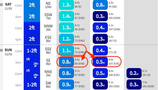
As a side note, estimating surf size from the mode guidance is tricky because the model us combining both swell trains on Saturday (as per the image below). You can see them split into single swell trains on Sunday between 12am and 6am - turning a 1.1m E/NE swell at 9.4 seconds (75 degrees) to a 0.5m E/SE swell at 8.6 seconds (107 degrees) and an 0.8m E/NE swell at 9.6 seconds (66 degrees). So, both day’s estimates are a little tricky to have confidence in.
I’m also of the mind that the models are slightly underestimating swell size from these sources, so with the potential for combined swell trains on Saturday and Sunday I think we may see the odd 2ft+ set on Saturday, easing to 1-2ft on Sunday.
Lastly, in Monday’s notes I mentioned the possibility for a flukey south swell to arrive on Saturday - originating from a very strong front/low combo south of Tasmania on Thursday - but this has vanished (almost) from the charts - so don’t count on it as a potential swell source.
That being said, the models now have a moderate front exiting eastern Bass Strait on Saturday that could become a small south swell producer for south facing beaches on Sunday. Let’s wait and see how Friday’s model runs are holding up.
Next week (Feb 13th onwards)
We’re still on track for a fairly significant frontal progression early next week, which should generate a solid building S’ly swell across Southern NSW.
I’m a little concerned that (at this early stage) that most of the front will be focused up into Victorian waters - in the Tasmanian swell shadow - but we should see at least a reasonable south swell through the first half of the week. Let’s fine tune this on Friday.
Otherwise, there are no definitive systems in the model guidance for our north-eastern swell window, but a heck of a lot of dynamic model output suggesting we’ll see the ingredients for a major system taking shape in the Coral Sea or South Pacific some time from later next week through the following week.
But as mentioned on Monday, I’m not confident in the long term model guidance right now because of the active monsoon pattern across the top end and possible Tropical Cyclone in the NW of West Oz, which always throws the models a little skew. More on this in Friday’s update.
Comments
Am I crazier to say yesterday was better than today? Fewer bodies, bigger and slabbier.
Agreed
agreed