Plenty of swell ahead, but lots of onshore wind

Sydney, Hunter and Illawarra Surf Forecast by Ben Matson (issued Monday 6th February)
Best Days: Thurs: improving conditions with an easing E/SE swell. Fri: small mix of swells and a possible light breeze before the nor'easter kicks in. Sat/Sun: small clean beachies.
Recap: Saturday was mainly small and weak - the mid-late afternoon saw minor lines from the SE for a few hours that could have been related to the perennial polar low SE of New Zealand earlier in the week, but there wasn’t much in it. On Sunday we saw a small combo of minor NE windswell and building long period S/SE groundswell from the polar low; peak swell periods kicked off around 17.4 seconds and have only eased very slowly since. Surf size was still managing a very inconsistent 2ft+ from this source this morning, though the early period of light winds around dawn gave way to a freshening southerly breeze that arrived much earlier than expected (my Friday notes had a “possible afternoon S’ly change” and even this morning expectations were for an afternoon arrival). Nevertheless, the distance between sets was considerable so there haven’t been a lot of waves around.
This week (Feb 7th - 10th)
Our current S/SE groundswell is on the way out so we won’t expect much from this region over the coming days.
A minor fetch is trailing today’s change but it’s not very wide nor very strong so I’m expecting surf size to remain small and weak through Tuesday. Local winds are tricky due to the position of a weak trough over the region - we should see a slight easing in the S/SE breeze (and a swing to the E/SE) but there’s certainly a risk for onshore conditions (more likely south of Sydney; the Hunter may see variable periods). But with the small weak surf there’s not much to bother with.
A broader developing surface trough off the Far South Coast will then strengthen an E/SE fetch in the south-western Tasman Sea during Tuesday, and this should give rise to a late pulse of short range E/SE swell across the South Coast. However, I’m not expecting much size north from Wollongong until overnight (and therefore into Wednesday).
This trough is unusually shaped, mainly due to a weak but elongated ridge through the Northern Tasman Sea and another supporting ridge to the south. In turn, it will create a long, thin E/SE fetch that should (by the early hours of Wednesday morning) stretch right across the Tasman Sea.
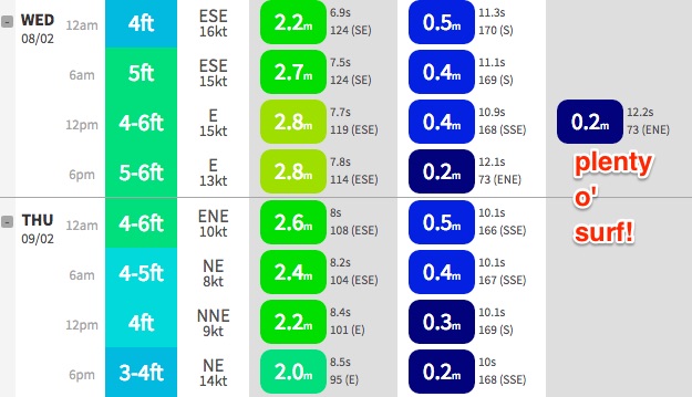
As such we’re looking at building short range E/SE swells across thew Illawarra/Sydney and Hunter coasts through Wednesday.
Based on model guidance, the strongest fetch will be positioned between Sydney and Wollongong so it’s plausible we will see the largest surf here. Most beaches should reach 4-5ft across the greater southern NSW coasts but occasional bigger sets are likely - but with moderate to fresh onshore winds there’s unlikely to be many locations out of the wind. Our model has 5-6ft for Sydney beaches but I think in general this will be a slight overcall.
Thursday morning is probably a better choice if you're planning which day to surf this week. As the trough moves north and weakens, so too will surface winds across southern NSW - in fact they’ll swing NE and freshen, particularly in the south. Surf size will be quickly on the decline; early 3-4ft sets are possible at exposed beaches (again, I think the model is overcalling the size) and it’ll trend down during the day.
Early Thursday morning may offer a period of lighter winds but without a synoptic offshore conditions will probably remain a little lumpy on the surface. Expect a small increase in NE windswell late afternoon that’ll peak into Friday with sets of around 2-3ft at NE facing beaches. The E/SE swell will be all but gone by this time.
Friday’s winds look a little tricky with a weak trough forming off the South Coast. This may result in a moderate S’ly change up to about Nowra but N/NE winds will probably persist about the Hunter and Sydney coasts, and maybe the Illawarra too. There’s a chance for a variable period somewhere out of Wollongong but I’ll have a closer look on Wednesday.
Also worth mentioning - not that you’ll be able to see it - but a developing anchored trade flow across the Northern Tasman Sea will generate an extended period of E’ly swell for the North Coast, and we’ll see a small undercurrent of this across Southern NSW. No major size but the odd set around 2ft or so at swell magnets from Wednesday onwards).
This weekend (Feb 11th - 12th)
The charts are very dynamic at the moment though it looks like we’ve got a small weekend of waves ahead.
Ultimately we're looking at a small blend of leftover NE windswell, a small long period S’ly swell from a deep (but poorly aligned) front/low combo passing south of Tasmania on Thursday, and some E/NE trade swell spread from the broad E’ly flow across the Northern Tasman Sea.
Estimating the precise swell trend is hard because only the S’ly swell will have a defined front, and even then it will probably just glance the coast, therefore only influencing a handful of reliable south swell magnets. The other swell trains will simply ebb and flow.
But as a ball park we should see peaky beachies around the 2ft mark, maybe some bigger bombs at south swell magnets through Saturday.
Winds look to be light and variable with sea breezes both days, and a possible late S’ly change on the Far South Coast Sunday afternoon.
Next week (Feb 13th onwards)
A fairly decent frontal progression is lining up for the lower Tasman Sea around Monday (that should give us a punchy south swell early-mid week), and there are some interesting developments across the Coral Sea and South Pacific that have potential for the second half of next week and beyond.
However, I’m not confident in the long term model guidance right now because of the active monsoon pattern across the top end and possible Tropical Cyclone in the NW of West Oz. This always throws the models a little skew, so let’s check back on Wednesday to see how they're tracking.
Comments
roll on winter
Winds were light during the day, lets hope tomorrow is the same!
Yeah the trough axis remained south, not likely tomorrow, moving north overnight.