Small weekend in Southern NSW; complex outlook for next week

Sydney, Hunter and Illawarra Surf Forecast by Ben Matson (issued Friday 19th August)
Best Days: Multiple 'possible' swell sources from Wed onwards but nothing to be overly confident about. Read on for more details!
Recap: Small residual swells for the last 36 hours.
This weekend (Sat 20th - Sun 21st August)
No major changes to the weekend outlook. Small surf is expected across all beaches, though conditions should be clean with mainly offshore winds.
Strengthening northerly winds off the coastal margin this afternoon and overnight are now forecast to be a little stronger than previous model guidance, which has marginally lifted the projected surf size for Southern NSW.
The Far South Coast will be the biggest beneficiary of this fetch with sets to 2-3ft early Saturday morning, however locations further north - i.e. much of the Sydney, Hunter and Illawarra coasts - will be much smaller, and this swell will only affect beaches facing north-east. In fact the Newcastle region often misses out completely from these events due to the very short fetch length and the shadowing by the Hunter curve (i.e. the coastline from Newcastle to Seal Rocks).
As such, most NE facing beaches across the Sydney and Illawarra coasts should pick up 1-2ft sets early Saturday morning, before trending down throughout the day - the responsible fetch will be exiting the swell window before sunrise, so the biggest waves will occur in the early part of the day. Winds will swing moderate to fresh W’ly then W/SW so it’ll be clean on top.
Minor trade swell activity should ensure most exposed beaches don’t go completely flat this weekend, however we probably won’t see much more than a lazy 1ft to maybe 1-2ft from this source, with very inconsistent sets. Expect smaller surf south of the Illawarra. I really wouldn't expect much from this source at all, so keep your expectations appropriately low.
The only other swell source for the weekend is a small W thru’ W/SW fetch exiting eastern Bass Strait on Saturday, that should generate a minor south swell for Sunday afternoon. The fetch isn’t very well positioned, and ordinarily I’d discount it as a notable swell source - but in the absence of any other energy (the trade swell will be very small and unreliable, and the N’ly windswell will be all gone by Sunday) it’s worth mentioning in these notes. We’ll probably start from a very small base early Sunday - tiny to flat at most regions - but after lunch, south facing beaches should pick up occasional 1-2ft sets into the afternoon. I don't think many locations south of Wollongong will pick up this swell either due the swell's 'axis of refraction'.
Conditions are looking generally clean on Sunday with light W’ly winds in the morning, but they’re expected to swing NW and then N’ly as a weak secondary front traverses Bass Strait - so with this new swell expected to build in size throughout the afternoon (biggest late in the day) you’ll probably have to tuck into a sheltered northern corner for the best conditions (and most size).
Next week (Monday 22nd onwards)
We’ve got some interesting synoptic developments in store for next week, in three separate swell windows.
First of all - a bombing low in the Southern Ocean (mentioned in Wednesday’s forecaster notes, that’s expected to generate epic waves for Vicco this weekend - see Craig's detailed notes here) will weaken and then traverse our southern swell window on Sunday. However, the only region of interest to us is a small embedded polar low around 67S, 157E on Sunday afternoon. The associated fetch looks good but it’ll be tracking eastwards - perpendicular to our swell window - so that factor, plus the large travel distance, significantly reduces its swell potential.
We’ll probably see some small S’ly swell fill in on Monday and Tuesday from a SW fetch across the north-western flank of the parent low (just south of Tasmania, also on Sunday) but no major size is expected, perhaps a few stray 1.5-2ft sets at south facing beaches.
A slightly stronger secondary fetch may provide a minor boost to this swell regime later Tuesday (South Coast) and Wednesday (everywhere else) but it's only low confidence energy.
Long period S’ly swell from the small polar low is then expected late Wednesday (South Coast) and Thursday (Sydney, Hunter and Illawarra coasts), but I’m not holding my breath for much more than a very inconsistent 2ft to maybe 2-3ft at exposed south swell magnets, with very long breaks between waves.
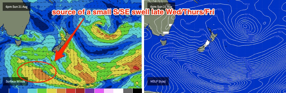
In fact, we may see similar distant S/SE energy right through Friday and possibly early Saturday, originating from the same low as it moves east. Although this track is not very favourable, it is expected to be sufficiently slow moving enough to capitalise on its position within the swell window, with a small swell spread likely to make its way back to Southern NSW. Again, this produces a low confidence outlook for very inconsistent 2ft to maybe 2-3ft sets at exposed south facing beaches.
Otherwise, I’ll also be keeping a close eye on buoy data next week, from the E/NE.
A deep mid-latitude low is intensifying E/NE of New Zealand’s North Island, and although this fetch will be mainly located behind the NZ swell shadow, we can’t discount some energy making landfall in Southern NSW (although it’ll be a fraction of the size of SE Qld and Far Northern NSW).
At this stage we have two small pulses expected Monday and Tuesday from the initial stages of this setup - though I can’t see there being much more than 1-1.5ft across most open beaches.
Stronger E’ly groundswell is then expected very late Tuesday (more likely Wednesday), with the leading edge peak periods expected to be up in the 15 second range. It’s really difficult to estimate potential surf size but I’d be surprised if we saw much more than a very inconsistent 2ft to maybe 2-3ft at exposed beaches from this source, with very long breaks between sets. Similar energy is then expected from the E/NE from this system through Thursday and Friday, probably a touch smaller (1-2ft, and very inconsistent).
Once again, this is a tricky swell from a very remote, shadowed swell source so confidence on this swell is very low.
And just to complicate the second half of next week even further, we have a deepening coastal trough from Wednesday onwards that’s expected to form a significant system in the Southern Tasman Sea. At this stage, model guidance suggests it’ll be aimed fair and square into Tasmania, with much smaller surf potential to northern locations (i.e. Sydney, Hunter and Illawarra coasts) - but the South Coast of NSW should pick up some solid surf from this source (East Coast Tas could see very large surf from this system).
However, this trough is expected to track east so it will probably result in just a single day of waves for the region.
At this stage the general size breakup looks somewhere in the 4-6ft range for the Far South Coast by Wednesday afternoon, 3-4ft across the South Coast up to maybe the Illawarra and 2-3ft across Sydney with smaller surf to the north. Initially fresh E’ly winds will swing N’ly then NW as the trough tracks off the coast, but due to the complexity of this system (and the fact that its still five days away from forming) we need some elasticity around these figures. Wave heights will then ease steadily into Thursday with offshore winds. I’ll reassess in more detail on Monday.
Eventually, this trough/low will move out into the Tasman Sea so a return southerly swell is likely later next week or the following week, but this is way off into speculation-land. Let’s see how things unfold over the coming days.
Have a great weekend, see you Monday!
Comments
That big low around next Wednesday, Ben, what swell direction are you expecting to see from it in NSW?
Few fun banks around. Swell was a lot punchier than expected. Let's hope it hangs around tomorrow morning
looks like there's a new run of southerly energy on the cards for Thursday. better than nothing!