Plenty of E/NE throughout the week, offshores persisting

Sydney, Hunter and Illawarra Surf Forecast by Guy Dixon (issued Monday 6th June)
Best Days: Each day of the week.
Recap:
 It’s been a wild few days with one of the strongest east/northeasterly swells in decade battering the NSW coast line. Over the weekend, stormy windswept conditions with an ECL built to a peak in the 10-12ft range on Sunday, with gale force onshore winds and flooding rains to match. Today, the breeze has let up and swung offshore on along the north side of the low allowing for very strong, but very impressive sets in the 10ft+ range, larger at offshore bombies.
Amongst the destruction, there some people are scoring all time waves.
This week (Tuesday 7th - Friday 10th):
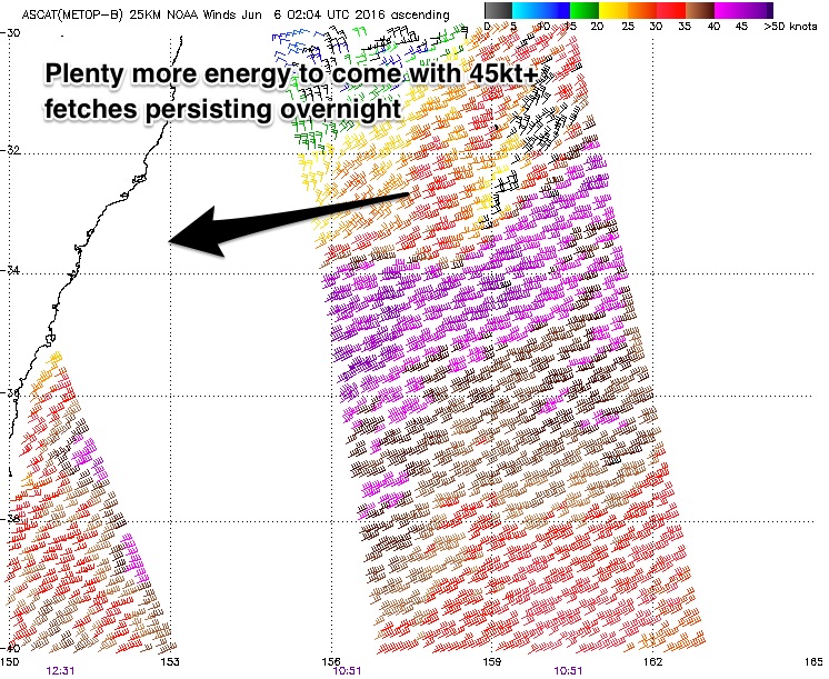
This strong east/northeasterly swell will slowly ease in the coming days, although trailing energy from the main northeasterly fetch which remains well established over the Tasman Sea will provide multiple period pulses in quick succession.
This fetch is best aimed towards the South Coast of NSW and northern Tasmania, stretching almost as far north as New Caledonia.
 A strong pulse late today should maintain sets in the 10ft range this afternoon, easing just a touch into Tuesday morning with sets in the 8ft+ range, likely the odd 10ft bomb. A second pulse is due on Tuesday afternoon, so I wouldn’t expect sets to fall below 8ft.
Wednesday morning should see the surf drop slightly further, but only by a small increment. Sets should be breaking in the 6-8ft range with exposed offshore reefs and bombs continuing to light up during the entire period.
The South Coast of NSW is likely to be bigger again due to the particularly good alignment of 50kt core fetches.
As the fetch drifts south and the alignment worsens, energy should also drop off fairly noticeably. Wednesday afternoon will probably ease relatively quickly, with Thursday easing from around the 4-6ft range.
A small intensification along the northern extension of this fetch (northeast of New Zealand) is forecast to provide a small pulse on Friday (maybe mid-morning), with sets breaking in 3-5ft range.
Conditions are likely to remain clean throughout the majority of the week, with winds swinging from west thru northwest each day. Only Friday will see the first hints of tending southwesterly, before a light seabreeze comes into play in the afternoon.
This weekend (Saturday 11th - Sunday 12th) and next week (Monday 13th onward):
The surf shouldn’t fall below around 3ft out of the east over the weekend and into early next week as the effects of this intensification fill in as it deepens and drifts eastward.
We should also have a small amount of southerly swell to contend with generated by a frontal progression moving to the south late week. The first signs of this energy may show themselves late on Friday at south facing beaches, more so on Saturday with sets in the 3ft+ range.
Sunday should see a better pulse of more substantial southwesterly core fetches over the southern Tasman Sea with sets moving into the 3-5ft range at south facing beaches, larger across the Hunter.
Each morning of the weekend should remain clean under a west/southwesterly airflow, preceding a weak seabreeze each afternoon. Monday is looking good, with northwesterly breeze holding into the early afternoon.
Comments
Here's a fun fact! The maximum wave reading on the Eden buoy was 17.67 metres - yes, you read that right - which passed the buoy at 4 am this morning. Put all the other data into the equation - average wave height, period - and it's equal to a 1 in 85 year event.
considering the NE direction rather than S, surely > 100yr event?
That's just going on size, not direction.
That was my point, would be interesting to know what it is when the direction is accounted for.
That's actually pretty fucking cool.
Did anyone a screenshot of the sydney ports buoy at botany? I saw it get up to 7.4m but its rolled off the back of the plot now.
From the last analysis done for sydney (2010) a 7.4m event from the NE sector would be well over 100yrs. But you need to put the new data point (this weekend) back in and re-analyse to get the true value. My task for tonight..
The MHL buoy is a mess, but seems to be around 100deg for the peak so its not in that sector anyway - I'd like to check the botany data to confirm.
Hs = 7.4m is <10yr ARI (not considering direction) if you're interested. We had an 8.1m last year
Here's one I got, screen shot just after 3pm on the 5th. Looks a tad short of 7 m.
Forecaster notes saying Wednesday morning should be 6-8ft before dropping later in the afternoon, is that still on track?? Surf Forecast saying 4-5ft... Been such a good swell hope it doesn't fade away anytime soon!
swell and period. time and date at top. i believe this shows the peak but could be wrong
clarification - peak at about 2pm - image taken about 11 pm
Champion, thanks!