Trade-swell the main ingredient this week

Sydney, Hunter and Illawarra Surf Forecast by Guy Dixon (issued Monday 25th April)
Best Days: Each morning preceding a seabreeze.
Recap:
Southerly windswell was a key contributor to swell on Saturday, with south facing beaches picking sets in the 3-5ft range, although lacking quality under an accompanying southerly airflow.
A more substantial southerly groundswell filled in on Sunday, maintaining options in the 3-4ft range across the magnets on Sunday, however gusty southeasterly breezes made it difficult to find a wave.
Today, a mix of easing southerly swell has been breaking across the NSW coast, accompanied by an element of easterly trade-swell which has been punching above its weight with sets in the 3ft+ range at open beaches. Conditions have remained clean for a good portion of the morning under a light offshore airflow, with only a light seabreeze coming up just before lunch.
This week (Tuesday 26th - Friday 29th):
A strong an elongated southwesterly fetch traversed the southern Tasman Sea over the weekend, aimed well and moving in a captured motion towards the far southern reach of New Zealand’s South Island.
While the alignment of this fetch was hopeless at it’s strongest point, it’s sheer intensity (50kt+ core winds) should provide a small amount of side band energy for the NSW coast. More notably however, the alignment of swell generating winds during the earlier stages of its life cycle were more favourable, despite being broader and weaker.
All factors considered, the easing trend off the back of the weekend’s swell is likely to continue into Tuesday, but should be slowed throughout the afternoon with options holding in the 2ft+ range at south facing beaches.
Swell out of our eastern and swell window looks to be much more reliable during the coming week however.
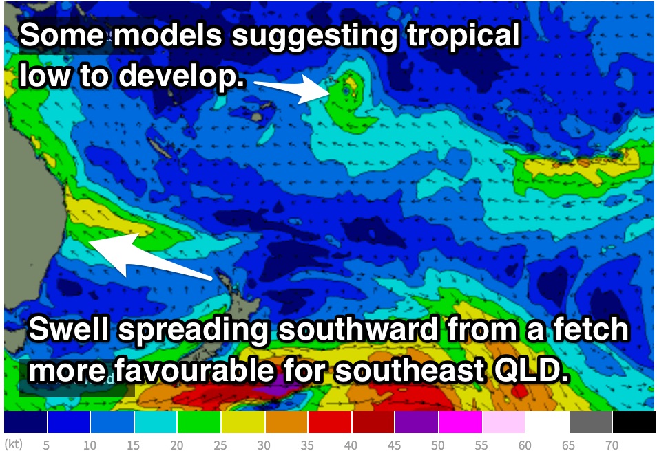 An elongated southeasterly fetch has been established with good alignment to the QLD coast over the past few days, resulting in today’s increase in swell for northern NSW and southern QLD.
Sideband energy off this fetch is due to filter down the coast, grading smaller further south and away from the swell source. Open beaches are due to pick up peaks in the 2-3ft range on Tuesday, holding at similar size on Wednesday, easing to around 2ft+ on Thursday.
A blocking high looks to then set up over the Tasman sea, deflecting frontal paths in a poor southeastward direction through the southern swell window.
Fetches along the northern quadrants of this ridge should broaden and tend more easterly however, with a subtle flow of easterly energy maintaining energy towards the end of the week, holding in the 2ft+ range on Friday.
Models now suggest a deep low and front to approach and move in a southeasterly direction south of Tasmania on Thursday, south of the aforementioned blocking ridge. While the storm track and size of the system are pretty woeful, westerly core winds look intense, up to 50kt at times.
Unfortunately, the effects off this system look negligible. At this stage we’d be lucky to pick up 1-2ft at south facing beaches into Saturday morning.
Conditions are likely to be clean each morning under offshore breezes, deteriorating each afternoon as a seabreeze comes up. Each day will see the morning winds swing progressively from the west/southwest on Tuesday, to the north/northwest by Friday.
This weekend (Saturday 30th - Sunday 1st):
Otherwise, easterly trade energy will be the main source of energy over the weekend, with open beaches holding at around 2ft from a broad and persistent trade fetch over the northern Tasman which we touched on earlier.
Selected locations with exposure to the northeast may see a slight increase in size on Saturday morning as a local northerly fetch increases along the coast on Friday evening preceding the aforementioned front.
Due to the modest wind strengths and brief duration before pushing offshore, we should only see around 1-2ft off this fetch alone.
Saturday morning is looking susceptible to a seabreeze, with a north/northwesterly airflow on the forecast for the morning, giving way to a northeasterly later.
Sunday however is looking more promising with clean conditions persisting under a northwesterly airflow continuing into the afternoon.
Further ahead:
There are indications that we may see an increase in easterly trade energy generated by a potential tropical low positioned over the tropical South Pacific. It's ambitious and long term, but at this stage the peak looks to be sometime around the weekend of the 7/8th of May if the scenario comes of.