A quiet week ahead, make the most of residual swell on Tuesday

Sydney, Hunter and Illawarra Surf Forecast by Guy Dixon (issued Monday 18th April)
Best Days: Tuesday morning, possibly Sunday morning.
Recap:
Easterly energy has been the main swell contributor throughout the weekend, with sets in the 2-3ft range on Saturday at open beaches, kicking late to around 3ft, holding throughout Sunday. Saturday morning offered good quality surf under a light northwesterly breeze before a northeasterly seabreeze came in.
Sunday on the other hand saw dicey conditions under a southerly airflow, although conditions cleaned up at times as breezes backed off and tended more southwesterly as the easterly swell persisted.
Today’s southerly groundswell came in strong with south facing beaches picking up solid 3-5ft sets, more in the 3-4ft range at open beaches. Light westerly breezes kept conditions groomed and lined up nicely for the early session preceding a wind change.
This week (Tuesday 19th - Friday 22nd):
Make the most of Tuesday as residual energy fades across the NSW coast. The coming week is looking fairly benign otherwise.
We can expect southerly energy to ease from the 3ft range across south facing beaches, maintained only by trailing fetches off the back side of the strong front which generated today’s pulse. Open beaches should fade slowly to around a similar size, as we enter a gradual easing trend of easterly energy.
The early morning is likely to offer clean options at most beaches under a light west/southwesterly breeze (westerly closer to Sydney). As the day wears on, breezes should swing through south to eventually prevail from the east/southeast.
Otherwise, frontal activity over the southern swell windows looks to be limited for the majority of the week. As the long wave trough becomes less pronounced, a strong ridge over the Tasman looks to develop, setting up a blocking pattern and deflecting any frontal activity to the south. As a result, any fronts that attempt to traverse the Tasman are likely to have particularly poor alignment to the NSW coast, making southerly swell potential over the coming week pretty negligible.
Usually in a scenario like this, we look to the Tasman ridge itself to become the main contributor of surf, but in this instance it doesn’t look to provide much swell of any significance.
Fetches along the northern quadrants of this ridge look to tend more easterly and increase slightly to the northwest of New Zealand’s North Island from around Wednesday. This should provide a small increase in easterly trade energy for Friday and into the weekend, but only modest with options around 2ft at open beaches.
Less consistent energy also looks to fill in across open beaches from mid-week generated by distant east/southeasterly trade fetches located over the tropical South Pacific east of Fiji.
The effects of this long-range and ordinarily aligned swell source should ebb and pulse between 1-2ft, with the bigger sets remaining inconsistent. Otherwise, background energy should maintain small options in the 1-2ft range, with light offshore breezes expected each morning preceding a seabreeze.
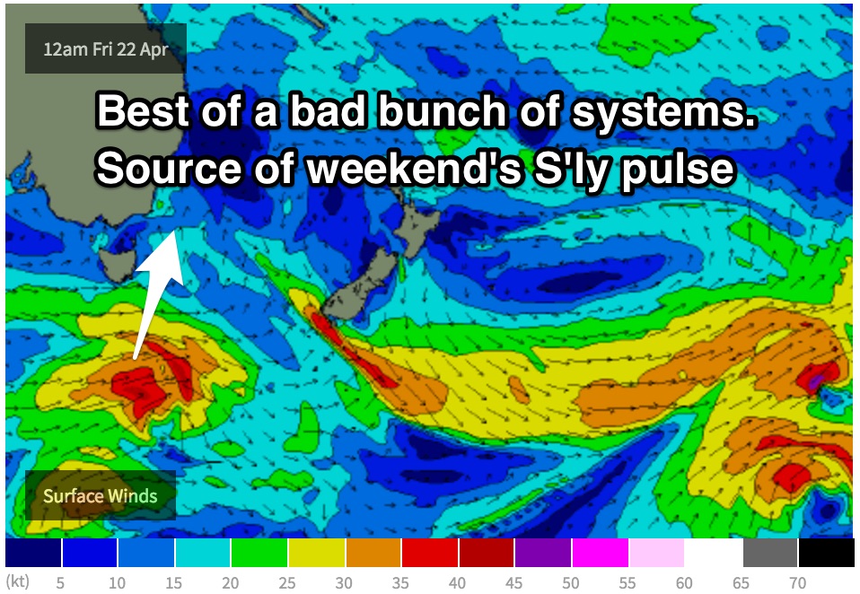
This blocking pattern is due to break down into Friday, with a moderately sized west/southwesterly trailing fetch following a weak front through the southern swell window.
A local change associated with this front is also due to move through from Friday morning, with south facing beaches seeing a building short range windswell into the weekend as a result.
As expected, the local nature of the swell generating fetch will have a severe impact on wave quality.
This weekend (Saturday 23rd - Sunday 24th):
 South facing beaches should peak at around 3ft by late morning on Saturday with a gusty south/southeasterly airflow leading to stormy, choppy conditions.
The groundswell off the more substantial distant fetches is due to fill in across exposed south facing beaches on Sunday with sets in the 3-4ft+ range, while shorter range energy from the day from the day before fades from around 2ft.
By this stage, winds should have eased and tended more east/southeasterly, with the outside chance of an offshore breeze during the early morning.
More detail on Wednesday.