Sunday the pick of the coming week

Sydney, Hunter and Illawarra Surf Forecast by Guy Dixon (issued Monday 4th April)
Best Days: Sunday
Recap:
The weekend started off well with a southerly swell easing from around 2-3ft under a light offshore breeze which persisted until early afternoon. Sunday saw the swell fade further, with few options exceeding 2ft. Southerly breezes swung southwesterly at times during the morning allowing for periods of workable waves, but generally speaking, Saturday was the stand out.
This morning, background energy was offering small options masked by the high tide, however we have since seen a small lift in size with a new southerly swell breaking in the 2ft range.
This week (Tuesday 5th - Friday 8th):
We are likely to be in between swells for the better half of Tuesday with a broad ridge suppressing the potential for any decent swell generation across the Southern Ocean and Tasman Sea. As a result, only left over background energy will be in the water, with small, weak options in the 1-2ft range.
An inland trough looks to deepen during Tuesday, interacting with a strong ridge over the Tasman. The pressure gradient looks to tighten as a result, steering an increasing local north/northeasterly fetch down the NSW coast.
This fetch looks to peak in strength late on Tuesday evening, most favourably aligned for the South Coast before the southern extension pushes offshore during Wednesday. Northeast facing beaches can expect the surf to build to around 2ft+ late on Tuesday, fading from around 2-3ft on Wednesday morning.
The very early session each morning may see a brief north/northwesterly breeze, soon swinging north/northeasterly as a part of the broader scale airflow.
A southerly change then looks to move up the coast during the night and into the early hours of Thursday morning, although not particularly strong or long lived. Meanwhile, a more substantial southerly groundswell also looks to fill in across south facing beaches, generated by stronger fetches associated with a low and front over the Southern Ocean.
This mix of energy should provide options in the 2-3ft range for south facing beaches on Thursday, although lacking quality as a local southerly breeze moves over the coast.
Following this pulse, continued southerly energy off the back of this low should maintain options in the 2ft range throughout Friday, with south facing beaches seeing the most energy.
Conditions should be clean and workable during the morning under a light/variable-southwesterly breeze, increasing from the east later.
This weekend (Saturday 9th - Sunday 10th):
 A small mix of east/northeast energy and south/southeasterly energy is on the cards for Saturday, with most beaches seeing options in the 1-2ft range.
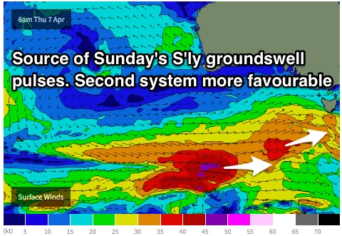
Sunday holds better prospects however, with a couple of pulses of southerly swell due to fill in.
The first pulse is due to originate southwest of WA, moving in a captured motion towards Tasmania. The second system looks to move over the active sea-state whipped up by the prior system, moving in a captured motion with better alignment, aimed more to the south of Tasmania.
As a result, exposed south facing beaches should be seeing inconsistent sets in the 2-3ft range, building to around 3-4ft by the afternoon as the second pulse fills in. Open beaches will be significantly smaller due to the swell direction.
Winds look to persist from the west virtually all day, going variable late. There should be plenty of opportunities for a wave, timed perfectly for the weekend warriors.
More detail on Wednesday.