Solid mix of S'ly and E/NE groundswell

Sydney, Hunter and Illawarra Surf Forecast by Guy Dixon (issued Monday 15th February)
Best Days: Each morning. Thursday is of particular interest.
Recap:
The NSW coast had the weekend off, with only small options breaking in the 1-2ft range on Saturday, smaller on Sunday. Each morning offered light breezes and clean conditions, becoming slightly impacted by a light/moderate seabreeze.
Today, small amounts of easterly and southerly energy have been breaking to provide options in the 1-2ft range at most locations. Again, conditions were clean early at open beaches under a light southwesterly breeze, but has since become bumpy.
This week (Tuesday 16th - Friday 19th):
We have a very active week ahead of us, with multiple swell windows generating plenty of energy.
Firstly, let's start off with an east/northeasterly groundswell generated by the interaction of a Tasman ridge and Tropical Cyclone Winston.
This system is currently located to the south of Fiji and is expected to move in a northeasterly direction over the coming days. A broad easterly fetch of 25-35kts is blowing along the southern quadrants of this system as it interacts with a ridge to the south.
Despite this fetch tending slightly more east/southeasterly throughout the Tuesday afternoon, models suggest a slight intensification along the southern quadrants of this system. We expect to see 30-35kt winds broaden slightly and extend further south which should provide an increase in swell late in the week, more so during the early stages of the weekend.
Meanwhile, a slightly weaker northeasterly fetch associated with the broader airflow located to the northwest of New Zealand’s North Island should maintain a good supply of background energy.
As a result, we should see subtle ebbs and pulses of east/northeasterly groundswell throughout the week, although inconsistent at times. We are looking at sets in the 3ft range on Tuesday and Wednesday before fading a touch on Thursday to the 2-3ft range.
As the effects of the intensifications begin to fill in, Friday should rise back to the 3ft range, preceding a peak on the weekend.
This easterly energy is only half the story however, we are still on track to see a healthy sized cut-off low move over the Tasman providing solid southerly energy.
Initially, we should see short range southerly energy build throughout Tuesday to the 3ft range generated by local southerly breezes, although lacking quality and power.
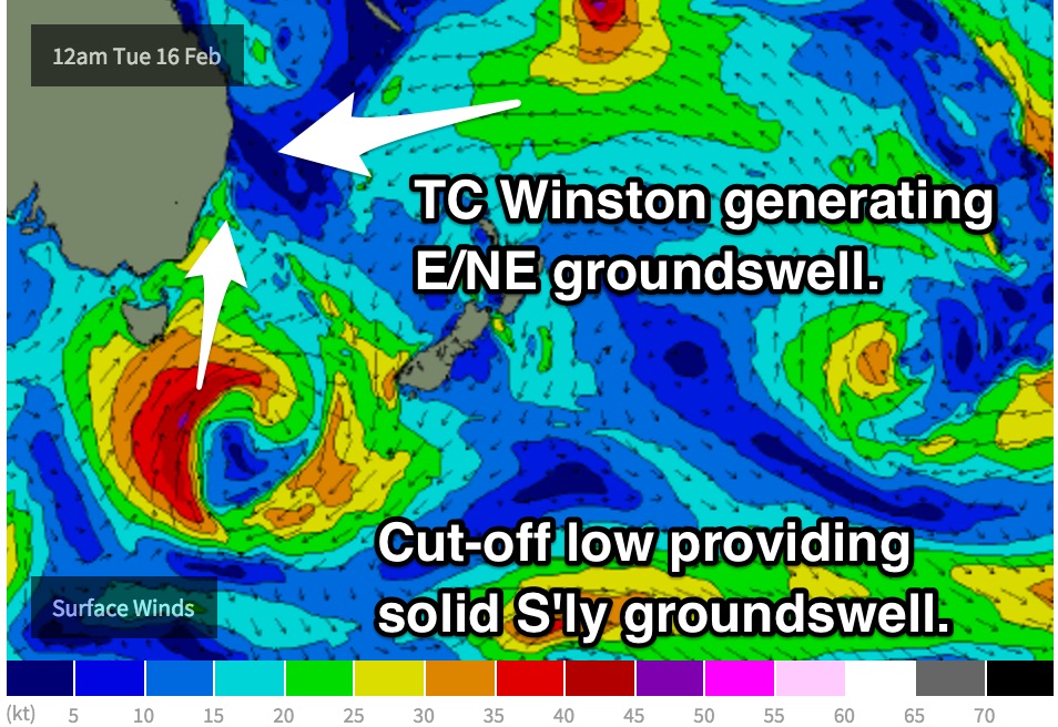 As this low moves east later this evening and into Tuesday morning, elongated southerly fetches are expected to move into our swell window, with core fetches of 40-50kts. This is likely to be the period of strongest winds, however throughout the later stages of Tuesday and into Wednesday a captured fetch of 30-40kts should push up with fair alignment towards the NSW coast.
More substantial groundswell is due to move up the coast on Wednesday, breaking across the south facing beaches in the 3-5ft range, larger on Thursday with sets in the 4-6ft range as the captured energy fills in, larger across the Hunter.
Off the back of this peak in swell, Friday should fade to the 3-4ft range, although that doesn’t rule out the odd rogue set.
Now for the wind outlook. Tuesday looks to be dominated by a gusty southerly breeze, however the early session has a good chance of swinging southwesterly early, so open beaches should offer some clean, workable options.
Similarly, Wednesday looks to be under a southerly breeze, although easing and tending southeasterly by the afternoon. Again, hit it early for clean and workable options across open beaches under a southwesterly airflow.
Thursday morning is looking solid and clean under a light/moderate westerly breeze, holding for a good part of the morning. Moving into the afternoon, an easterly seabreeze should kick in and have an impact on quality.
Finally, Friday morning is looking at a light/variable airflow early, tending northeasterly and increasing during the mid-late morning.
This weekend (Saturday 20th - Sunday 21st):
Southeasterly fetches off the backside of the aforementioned low as it moves east have fairly good alignment to the NSW coast initially, however as the main swell generating core fetches increase, the alignment is more southerly and less favourable.
We should still see side band energy maintaining swell in the 3-4ft range throughout Saturday, favouring south swell magnets. Meanwhile, casting our minds back to the east/northeasterly groundswell, we should see the open beaches peak with sets in the 3-4ft range.
Moving off the back of these swells, Sunday should see this energy fade slowly from the 3ft range at most beaches.
Some model disagreement is creeping in by this stage of the wind forecast. Some models suggest a light/variable-offshore breeze early on Saturday morning with a weak southerly change moving throughout late morning as a small trough shifts overhead. Other models have that southerly coming through early in the morning.
We hope for the former scenario to play out, then we get another morning of fun waves. If not, open beaches have the potential to see a south/southwesterly breeze early.
Funnily enough, Sunday is struggling with a similar scenario. We're hoping for early light winds, but there is a fair chance of a southerly breeze which would be best handled by open beaches.
Next week (Monday 22nd onward):
Things get interesting later in the week where the northeasterly motion of Winston slows and retrogrades westward leading into the weekend. During this time, broad fetches to the south of this system look to tend easterly once again, while strengthening slightly and extending further south.
This re-intensifications has the potential to generate another pulse of east/northeasterly groundswell across open beaches, most likely peaking on Tuesday in the 3-4ft range.
Meanwhile, frontal activity over the southern ocean, although poorly aligned should maintain at least 2ft during the early stages of next week.
Comments
It just bums me when two different swells run at the same time.
That second swell source comes in handy when the winds favour some places and not others though
Really? I would have thought dual swells would be a good thing at most open beaches. Helps to break up otherwise bankless beachies.
That's the problem where I'm from one swell a certain wind other direction other
wind. Just sucks cannot work with both. And then you have 2 swell directions at the same time which eliminate 2 certain reef breaks. Just leaves me with the worst
beach breaks. Yes I'm having a whinge.
Bondi's looking super fun this morning.
I was looking forward to surfing on Islands , points and Bommies with lots
of rocks. Can surf beachies any day.
Hey Ben/Guy/Craig, I forget which thread it was, but there was recently discussion about what factors go into creating large swell periods. I'm curious: given a longer swell period is the function of both stronger winds and distance from source, what influences consistency? As I understand it, the surf becomes more inconsistent as the distance to the storm increases. Is it possible to have, say, a consistent 16 + second swell?
Hi Jim, just answered in the other thread :)
You beauty, cheers Craig
tomorrow morning looking the business
dunno mate, looks like a carbon copy of the last few mornings which have been lacklustre. gonna hit it real early hopefully the higher tide works better on our current banks.
Winds looking more SW (as opposed to W) and not persisting for as long. Forecast will be publised in a cuple of hours.
E/NE groundswell in the water this morning to a good 3ft+ on the sets. Great to see!